
St Abb's Head, St Abb's Nunnery


Castle (Medieval), Ditch (Period Unassigned), Hall (Period Unassigned)
Site Name St Abb's Head, St Abb's Nunnery
Classification Castle (Medieval), Ditch (Period Unassigned), Hall (Period Unassigned)
Alternative Name(s) Rampart Hall
Canmore ID 60174
Site Number NT96NW 6
NGR NT 91093 69387
Datum OSGB36 - NGR
Permalink http://canmore.org.uk/site/60174


- Council Scottish Borders, The
- Parish Coldingham
- Former Region Borders
- Former District Berwickshire
- Former County Berwickshire
NT96NW 6 91093 69417
(NT 9108 6940) St Abb's Nunnery (NR) (remains of)
OS 1:10,000 map, (1976).
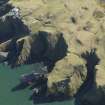
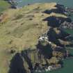
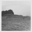
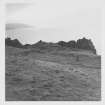
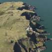
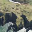
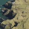
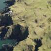
This is the traditional site of the 7th century double monastery founded by St Aebbe (for further details, see NT96NW 17). The remains here consist of a rectangular foundation (said to be a chapel - D MacGibbon and T Ross 1896; OS 6"map, annotated by O G S Crawford 1 September 1933 - although it runs NE-SW) lying on a rocky promontory which is cut off at the neck by a partly rock-cut ditch with the remains of a mortared wall on its inner lip. According to Carr further traces of this wall were visible in 1836 round the 'precipitous margins' of the promontory. The foundations, of undressed local stone bonded with lime-and-shingle mortar measure internally 60ft by 22ft within walls about 4ft thick. In the centre of the W wall there is an internal recess, about 6ft long by 2 1/2ft wide. An annexe, 9ft by 13ft, adjoins the E end of the NE wall. Crawford noted two additional foundations, one at NT 9111 6940 and the other immediately outside the E end of the ditch, also suggestions of cultivation patches outside the ditch.
The site is referred to in indentures as the 'Promontory of Abbsbrugh' (D MacGibbon and T Ross 1896) and, in spite of the strong religious tradition, it was known to the inhabitants of Coldingham and vicinity, in 1856, as 'Rampart Hall'(Name Book 1856).
J Stuart 1868; D MacGibbon and T Ross 1896; A A Carr 1836.
This site is as described above. The large rectangular foundation measures 18.7m by 6.6m and 0.5m high. The walls, however, are mainly of drystone construction except for the recess which is bonded with lime mortar. Three blocks of mortared masonry remain of the wall which lay behind the rock-cut ditch, which is 2.0m deep. There is a slight scarp behind this again, which may denote the line of an earlier (?) wall or rampart.
Two platforms at NT 9180 6941 and NT 9111 6940 may denote the sites of buildings, and at NT 9110 6931 is the small square foundation of a possible building outside the ditch. No traces of walling around the perimeter of the promonotory were found.
(Surveyed at 1:2500 by Field Surveyor.)
Visited by OS(RD) 11 March 1966.
Limited excavations were carried out in September 1980 in an attempt to locate the early fortification implied in the 7th century place name Colodaesburg. Excavation at this site revealed that the defences were not finished. An internal building appeared to be secular rather than ecclesiastical. There were no datable finds, but a late medieval date seems likely.
L and E A Alcock 1980
Over the past century, this defended promontory has been identified as the site of St Aebbe's monastery. This identification has been accepted by eg Crawford (O G S Crawford 1934), who saw the defence-work as a sub-Roman mortared wall, and by Thomas (C Thomas 1971). However, this poses problems as (i) the promontory seems too small, and the amount of level ground too restricted, to hold a double monastery. (ii) sea access, as required by Bede's story about St Cuthbert, is impossible. (iii) when seen in 1978, the supposed remains of the nunnery (OS 1:10,000 map {1976}) appeared to be those of a later medieval hall rather than an ecclesiastical building.
This view has also been reached independently by staff of the RCAHMS and the Society of Antiquaries field surveyors (RCAHMS 1980). It should also be noted that prior to the O S identification (Name Book 1856), the traditional site for this monastery had been Kirk Hill (NT96NW 17) (Information from A D S Macdonald).
In 1980, a trench was cut through the wall crossing the promontory, and it was deduced from the results that here was an unfinished work, intended to be a masonry wall, 10ft wide, founded on solid rock at one end (or perhaps both ends) but elsewhere to be based on a clay-bound raft of rubble. Only part of the raft and wall was completed. Excavations were also carried out at the building identified at the remains of St Abb's Nunnery, in the recess noted by OS field surveyor (RD), and the adjoining gable wall. Little evidence was obtained; it was inferred that the building originally had a flagged floor, and on its abandonment, the flags were lifted. There were no datable finds. The mortared wall of the recess seemed to mark an improvement to the original structure. The mortar itself was not inconsistent with that in the wall across the promontory, so it is probable that both the wall and the building are contemporary. For both, a secular rather than an ecclesiastical function seems likely. At best, this is an unlikely site for the monastery.
RCAHMS 1980, visited 1979; L Alcock and E A Alcock 1981; L Alcock 1981; C Thomas 1971.
The traditional site of the 7th century double monastery founded by St Aebbe. A rectangular foundation which was said to be a chapel lies on a rocky promontory which is cut off at the neck by a partly rock cut ditch with the remains of a mortared wall on its inner lip. The RC considered this site to be rather of a later medieval hall. Excavations in 1980 provided no datable finds. The mortared wall is exposed to erosion. The foundations of the possible chapel are grass covered and not exposed to marine erosion.
Site recorded by GUARD during the Coastal Assessment Survey for Historic Scotland, 'The Firth of Forth from Dunbar to the Coast of Fife' 10th March 1996.
NT 87 70 to NT 91 67 An archaeological survey was undertaken by Headland Archaeology Ltd of land owned by the National Trust for Scotland at St Abb's Head, Lumsdaine Shore and Blackpotts. A total of 18 features, or groups of features, of archaeological and historical interest were recorded, ten already documented, at least in part, in NMRS records.
NT 9108 6940 Hall, defended promontory
Sponsors: Historic Scotland, National Trust for Scotland
S Carter 1997
NT 9108 6940 As part of the survey conducted by Headland Archaeology Ltd on behalf of the National Trust for Scotland on its land at and near St Abb's Head, mentioned above (S Carter 1997), this site was examined and recorded. Headland Archeology Ltd say that the site is as previously described, a substantial rock-cut ditch with a fragmentary mortared stone wall cuts off a promontory which contains a large rectangular stone foundation and at least two other possible building platforms. The site was plotted in detail by Ainslie in 1782 (Plan of Northfield, Scottish Record Office RHP 43284) and the principle surviving fragment of mortared enclosure wall was clearly the only visible portion of that wall even then. The promontory is well vegetated with a stable grass cover, the most substantial visible fragment of the mortared enclosure wall is undermined and must be at some risk of collpse. Furthermore there is an active erosion scar adjacent to this fragment. Some rabbit burrows were noted at the outer end of the promontory, beyond the hall, but they do not appear to be a significant issue but should be monitored.
Sponsors: National Trust for Scotland and Historic Scotland
NMRS MS/899/44 (Headland Archaeology Ltd. 16/10/1997)
It is suggested that the name Rampart Ha has been shortenend from 'Rampart Haugh', 'haugh' meaning 'flat ground'.
Information from R Weatherhead, 13 February 2003.
Field Visit (20 August 1908)
76. St Ebba's Chapel, St Abb's Head.
The remains known as St Ebba's Chapel are situated on a rocky promontory, part of St Abb's Head, ¼ mile west-north-west of the lighthouse. Little more than the foundations of the building are now apparent, the highest portion of wall being at the west end, where it is 3 feet high. The internal measurements are-length 69 feet, width 22 feet, thickness of wall about 4 feet. A slight projection at the northeast corner, 9 feet square, may be a chancel or a sacristy. There is a recess in the west wall 6 feet long and 2 feet 6 inches wide, probably for a tomb. The neck of the promontory is traversed by a deep depression or ditch, retaining on the crest of the scarp the remains of a thick mortar built
wall.
See Eccles. Arch., i. p. 437 (plan); Carr's Coldingham, p. 243;
Ber. Nat. Club, 1863-68, p. 207, 1890-91, p. 116.
RCAHMS 1915, visited 20th August 1908.
OS Map: Ber., v. NE. and vi. NW. (‘Nunnery’).
Field Visit (16 October 1997)
NT 9108 6940 As part of the survey conducted by Headland Archaeology Ltd on behalf of the National Trust for Scotland on its land at and near St Abb's Head, mentioned above (S Carter 1997), this site was examined and recorded. Headland Archeology Ltd say that the site is as previously described, a substantial rock-cut ditch with a fragmentary mortared stone wall cuts off a promontory which contains a large rectangular stone foundation and at least two other possible building platforms. The site was plotted in detail by Ainslie in 1782 (Plan of Northfield, Scottish Record Office RHP 43284) and the principle surviving fragment of mortared enclosure wall was clearly the only visible portion of that wall even then. The promontory is well vegetated with a stable grass cover, the most substantial visible fragment of the mortared enclosure wall is undermined and must be at some risk of collpse. Furthermore there is an active erosion scar adjacent to this fragment. Some rabbit burrows were noted at the outer end of the promontory, beyond the hall, but they do not appear to be a significant issue but should be monitored.
Sponsors: National Trust for Scotland and Historic Scotland
NMRS MS/899/44 (Headland Archaeology Ltd. 16/10/1997)
Resistivity (18 April 2011 - 19 April 2011)
An earth resistance survey was carried out on Kirk Hill by the Edinburgh Archaeological Field Society (EAFS) on 18th and 19th April 2011 (Rhodes 2011). An area around the church, its rectangular enclosure and a nearby rectangular building were targeted.
EAFS used a TR/CIA meter to collect data at a probe separation of 0.5m with readings collected at a sample interval of 1m along transects spaced 1m apart over grids measuring 20m x 20m. They downloaded the data using a program called “Resistivity” and processed the data using the free software “Snuffler”. The quality of data collected was high and revealed the remains of the Kirk and its enclosure boundary as high resistance anomalies with the rectangular building also showing higher values. The layout of the Kirk was suggested to be more complex than first thought and some additional anomalies of possible archaeological interest were identified to the north of this building.
Report: RCAHMS, Scottish Borders Council and the National Trust for Scotland
Funder: EAFS; Hunter Archaeological and Historical Trust
Edinburgh Archaeological Field Survey, 2011
Project (13 December 2011 - 14 December 2011)
A detailed gradiometer and earth resistance survey was conducted over the site of Kirk Hill, St Abb’s Head, Berwickshire. The site has previously been identified as the location of an enclosed medieval church. To the west of the church and its rectangular enclosure a larger ‘C’ shaped bank incorporates the church, its enclosure and a number of possible structures. This site has tentatively been identified as the location of St Æbbe’s monastery mentioned by Bede.
The gradiometer survey covered approximately 1.75ha and demonstrated the presence of extensive archaeological features within the ‘C’ shaped enclosure. The earth resistance survey covered 0.43ha and identified anomalies of archaeological interest.
The medieval church and its accompanying rectangular enclosure were identified in both the earth resistance and gradiometer data. A rectangular stone building was identified to the west of the enclosure and another possible structure was identified to its north in the gradiometer data. A number of linear anomalies were identified in the southern portion of the gradiometer survey area; putatively identified as boundaries with two possible structures constructed against them.
Resistivity (13 December 2011 - 14 December 2011)
An earth resistance survey was conducted over the site of Kirk Hill, St Abb’s Head, Berwickshire. The earth resistance survey covered 0.43ha and identified anomalies of archaeological interest.
Magnetometry (13 December 2011 - 14 December 2011)
A detailed gradiometer survey was conducted over the site of Kirk Hill, St Abb’s Head, Berwickshire. The gradiometer survey covered approximately 1.75ha and demonstrated the presence of extensive archaeological features within the ‘C’ shaped enclosure.
Sbc Note
Visibility: This site has been excavated.
Information from Scottish Borders Council

