
Fishwick Mains


Settlement (Period Unassigned)
Site Name Fishwick Mains
Classification Settlement (Period Unassigned)
Canmore ID 59998
Site Number NT94NW 21
NGR NT 91762 49768
Datum OSGB36 - NGR
Permalink http://canmore.org.uk/site/59998


- Council Scottish Borders, The
- Parish Hutton (Berwickshire)
- Former Region Borders
- Former District Berwickshire
- Former County Berwickshire
Note (17 February 2016 - 4 August 2016)
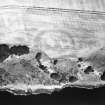
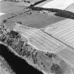
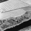
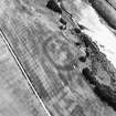
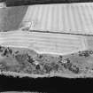
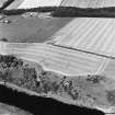
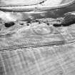
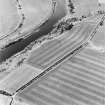
Cropmarks have revealed the site of a fort on the edge of the escarpment above the N bank of the River Tweed SE of Fishwick Mains. D-shaped on plan, the fort exploits a shallow promontory formed where the escarpment is steepest, and measures internally 90m from E to W along the chord formed by the escarpment by 70m transversely (0.52ha). The defences comprise a single broad ditch, possibly as much as 7m in breadth, and while there is little evidence of an internal rampart, the scar of a broad external bank can be seen on some of the photographs, Several irregular and diffuse maculae are visible within the interior, and there is possibly an entrance on the ESE, though the cropmark of the ditch in this sector is not particularly well-defined.
Information from An Atlas of Hillforts of Great Britain and Ireland – 04 August 2016. Atlas of Hillforts SC4117
Sbc Note
Visibility: This site is visible as a cropmark.
Information from Scottish Borders Council

