
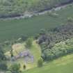
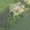
Blanerne Castle


Castle (Medieval), Tower House (Medieval)
Site Name Blanerne Castle
Classification Castle (Medieval), Tower House (Medieval)
Alternative Name(s) Lumsden Castle; Blanerne House
Canmore ID 59689
Site Number NT85NW 10
NGR NT 83182 56362
Datum OSGB36 - NGR
Permalink http://canmore.org.uk/site/59689


- Council Scottish Borders, The
- Parish Bunkle And Preston
- Former Region Borders
- Former District Berwickshire
- Former County Berwickshire
NT85NW 10 83182 56362
NT85NW 27.00 83224 56426 Blanerne
(NT 83182 56362) Blanerne Castle (NR) (Remains of)
OS 6" map, (1957).
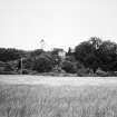
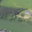
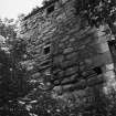
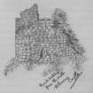
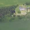
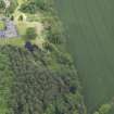
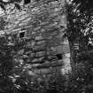
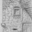
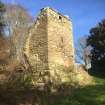
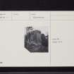
Blanerne Castle, dated by MacGibbon and Ross to their '4th period': 1542-1700, consists of two detached buildings which may once have been united. That to the E, called the 'Keep', is very ruinous; the other, called the 'Guard House', is better preserved.
D MacGibbon and T Ross 1892; RCAHMS 1915, visited 1908.
The two buildings, of rubble masonry, appear to be contemporary. The 'Keep' measures 5.0m by 8.0m over 0.9m thick walls and has the remains of a small circular turret near the SE corner. The 'Guard House' is a three- storeyed tower, 5.0m by 5.0m by some 12.0m high, with the remains of a corbelled turret at the NE angle. Just N, there is a low, walled enclosure, 5.0m square by 1.0m high, possibly the remains of another building.
Visited by OS (IA) 13 December 1972.
All that remains of Blanerne Castle is one wing of a tower-house and a two-storeyed building with an oven at its S end.
RCAHMS 1980, visited 1979.
EXTERNAL REFERENCE:
Scottish Record Office:
GD/157/1992
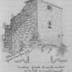
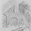
View of a castle (probably Blanerne), sketch by H.D. Scott of Harden, c.1808
Field Visit (24 October 1908)
14. Blanerne Castle.
Blanerne Castle is situated in close proximity to the modern mansion-house, and consists of two ruined and detached buildings. The easternmost, known as the Keep, is very ruinous; that to the west, a small rectangular building now called the ‘Guard House’, showing the remains of a turret at the northeast angle, is somewhat less so. The doorway faces to the east, and on the wall above it is a window with a carved chequered stone under the sill. The walls are 4 feet 6 inches thick.
RCAHMS 1915, visited 24 October 1908.
See Cast. and Dom. Arch., iv. p. 383 (illus.); Carr’s Coldingham, p. 81 (illus.).
OS Map: Ber., xvii. NW.
Note (2 November 2015)
This monument was delisted and was removed from the list of buildings of special architectural or historic interest.
The structure is still designated as a scheduled monument under the Ancient Monuments and Archaeological Areas Act 1979.
Information from Historic Environment Scotland, 2 November 2015
Sbc Note
Visibility: Upstanding building, which may not be intact.
Information from Scottish Borders Council

