|
Manuscripts |
MS 307/264 |
|
Statistical account, agricultural survey |
|
Item Level |
|
|
Photographs and Off-line Digital Images |
BWD 72/1 PO |
General Collection |
Photographic copy of drawing showing town plan. |
1824 |
Item Level |
|
|
Manuscripts |
MS 307/199 |
Historic Scotland. Scottish Burgh Survey. |
Scottish Burgh Survey research material. |
|
Item Level |
|
|
Prints and Drawings |
DC 1602 |
Historic Scotland. Scottish Burgh Survey. |
Map showing archaeological potential of various areas. |
1981 |
Item Level |
|
|
Prints and Drawings |
DC 1603 |
Historic Scotland. Scottish Burgh Survey. |
Map indicating listed buildings, conservation area and sites of major monuments. |
1981 |
Item Level |
|
|
Prints and Drawings |
DC 1604 |
Historic Scotland. Scottish Burgh Survey. |
Map of Duns in its local setting. |
1981 |
Item Level |
|
|
Prints and Drawings |
DC 1605 |
Historic Scotland. Scottish Burgh Survey. |
Map showing antiquities of the Duns area. |
1981 |
Item Level |
|
|
Prints and Drawings |
DC 1606 |
Historic Scotland. Scottish Burgh Survey. |
Working map showing archaeological potential of various areas. |
1981 |
Item Level |
|
|
Prints and Drawings |
DC 1607 |
Historic Scotland. Scottish Burgh Survey. |
Working map showing listed buildings, conservation area and sites of major monuments. |
1981 |
Item Level |
|
|
Photographs and Off-line Digital Images |
BWD 52/19 |
Survey of Private Collections |
Photographic copy of drawing showing list of prices for building materials. |
|
Item Level |
|
|
Photographs and Off-line Digital Images |
BWD 52/20 |
Survey of Private Collections |
Photographic copy of drawing showing list of prices for building materials. |
|
Item Level |
|
|
Photographs and Off-line Digital Images |
A 75993 |
Survey of Private Collections |
Photographic copy of drawing showing plan of feus next to Castle Gate. |
1773 |
Item Level |
|
|
All Other |
G 97675 NC |
|
Newscutting.
Views of houses in Market Square. including text. |
25/8/1978 |
Item Level |
|
|
Manuscripts |
MS 60 |
|
Lists of houses of historic interest compiled by I G Lindsay and the Marquess of Bute.
National Trust list index, 1940.
Provisional list of towns visited, 1936.
Lists and photocopied plans, 1936.
Original town maps, 1936. |
1936 |
Item Level |
|
|
Photographs and Off-line Digital Images |
C 44671 |
|
View of group of people in motorcar, Duns. The same group appear in photographs of Dr Welsh's House, Haddington. |
1910 |
Item Level |
|
|
Photographs and Off-line Digital Images |
C 44670 |
|
View of group of people in motorcar, Duns. The same group appear in photographs of Dr Welsh's House, Haddington. |
1910 |
Item Level |
|
|
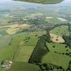
Photographs and Off-line Digital Images |
E 63079 CN |
RCAHMS Aerial Photography |
General oblique aerial view centred on the town, taken from the NNE. |
11/7/2005 |
Item Level |
|
|
Photographs and Off-line Digital Images |
E 63080 CN |
RCAHMS Aerial Photography |
General oblique aerial view centred on the town, with the remains of the redoubt and fort adjacent, taken from the N. |
11/7/2005 |
Item Level |
|
|
Photographs and Off-line Digital Images |
E 63082 CN |
RCAHMS Aerial Photography |
General oblique aerial view looking towards the town, with the country house adjacent, taken from the NW. |
11/7/2005 |
Item Level |
|
|
Photographs and Off-line Digital Images |
E 63084 CN |
RCAHMS Aerial Photography |
General oblique aerial view looking towards the town, with the country house adjacent, taken from the W. |
11/7/2005 |
Item Level |
|
|
Photographs and Off-line Digital Images |
E 63089 CN |
RCAHMS Aerial Photography |
Oblique aerial view centred on the town, taken from the NNW. |
11/7/2005 |
Item Level |
|
|
Photographs and Off-line Digital Images |
E 63090 CN |
RCAHMS Aerial Photography |
Oblique aerial view centred on the town, taken from the NW. |
11/7/2005 |
Item Level |
|
|
Photographs and Off-line Digital Images |
E 63091 CN |
RCAHMS Aerial Photography |
Oblique aerial view centred on the town, taken from the NW. |
11/7/2005 |
Item Level |
|
 |
On-line Digital Images |
SC 987751 |
RCAHMS Aerial Photography |
General oblique aerial view centred on the town, with the remains of the redoubt and fort adjacent, taken from the N. |
11/7/2005 |
Item Level |
|


