
Hardacres Hill


Fort (Prehistoric)
Site Name Hardacres Hill
Classification Fort (Prehistoric)
Canmore ID 58567
Site Number NT74SW 8
NGR NT 7430 4191
Datum OSGB36 - NGR
Permalink http://canmore.org.uk/site/58567


- Council Scottish Borders, The
- Parish Eccles
- Former Region Borders
- Former District Berwickshire
- Former County Berwickshire
NT74SW 8 7430 4191.
(NT 7430 4191) Fort (NR)
OS 6"map, Berwickshire, 2nd ed.(1909).
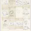
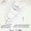
This fort has been almost completely ploughed out (RCAHMS 1915) but a double row of trenches was visible on the W side in the mid-19th century (J Hardy 1885). It was marked as circular on Armstrong's map (A Armstrong). (See RCAHMS plan,fig.56).
RCAHMS 1915.
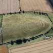
Situated on a ridge at the SW end of Hardacres Hill are the ploughed-out remains of a fort. A ditch, now some 17.0m wide and 1.2m deep, and the inner scarp of one of two ramparts, maximum height 1.2m, survive across the NE neck, and at the SW end there are traces of two terraces, possibly denoting former ramparts. It is doubtful if any artificial defences existed along the sides of the ridge which are protected by steep natural slopes.
Resurveyed at 1:2500.
Visited by OS(RD) 31 October 1966.
This earthwork occupies the SW end of a steep-sided ridge.
The level approach from the NE was barred by two substantial banks, now almost entirely removed by cultivation, and a broad medial ditch; between the inner bank and ditch there is a berm 9m wide. There are slight indications of a ditch on the S, but no traces of defences survive on the NW and SE.
RCAHMS 1980, visited 1979.
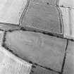
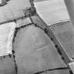
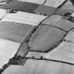
This earthwork is now classified as a fort, and is visible only as cropmarks on recent aerial photographs (RCAHMSAP 1995).
Information from RCAHMS (KJ) 11 January 2000.
Field Visit (23 October 1908)
142. Fort, Hardacres Hill.
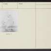
Traces of fortifications (fig. 76 [DP 229125]) remain on the south-west end of Hardacres Hill, at an elevation of about 300 feet above sea-level. They are situated in arable land under cultivation, and are almost entirely obliterated.
RCAHMS 1915, visited 23rd October 1908.
OS Map: Ber., xxviii. NW.
Note (29 January 2016 - 30 May 2016)
Parchmarks in grass and upstanding traces of the defences reveal the site of a substantial fort on the gently sloping crest of a ridge dropping down SW from the summit. Oval on plan, the massive defences are best preserved on the NE, where they traverse the crest, comprising two broad ditches with upstanding traces of not only the inner rampart but also a counterscarp rampart accompanying the outer ditch, which is up to 16m in breadth and still 1m in depth; together they form a belt about 45m deep. The inner of two concentric scarps visible at the SW end probably marks the line of the inner rampart and the parchmarks reveal the two ditches completing the circuit. Resolving the various features noted on the ground and visible on aerial photographs and satellite imagery is fraught, but assuming that the innermost features depicted by James Hewat Craw about 1912 (RCAHMS 1915, 79, no.142, fig 76) broadly conform to the line of the inner rampart, the interior measures about 100m from NE to SW by 70m transversely (0.55ha). The parchmarks are too diffuse and faint to be certain of the position of any entrances, but on the ENE the parchmark of the outer ditch appears to terminate abruptly on the SE margin of the ridge, possibly indicating a causeway at this point. No features are visible within the interior.
Information from An Atlas of Hillforts of Great Britain and Ireland – 30 May 2016. Atlas of Hillforts SC4050
Sbc Note
Visibility: This is an upstanding earthwork or monument.
Information from Scottish Borders Council

