
Elwart Law


Settlement (Period Unassigned)
Site Name Elwart Law
Classification Settlement (Period Unassigned)
Canmore ID 58506
Site Number NT74NW 26
NGR NT 73407 45318
Datum OSGB36 - NGR
Permalink http://canmore.org.uk/site/58506


- Council Scottish Borders, The
- Parish Greenlaw
- Former Region Borders
- Former District Berwickshire
- Former County Berwickshire
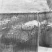
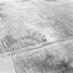
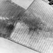
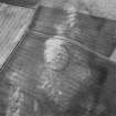
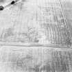
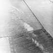
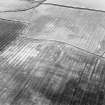
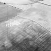
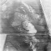
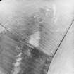
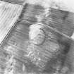
Aerial photography has revealed a cropmark in a field to the east of Elwartlaw farmsteading. The cropmark reveals a buried ditch, enclosing an oval-shaped area. This may be the site of a settlement of prehistoric date.
Within the enclosure, a further cropmark can be seen, which may represent the remains of a circular house. An earthen rampart would probably have accompanied the ditch around the settlement, with one possible entrance facing south-west.
Text prepared by RCAHMS as part of the Accessing Scotland's Past project
Sbc Note
Visibility: This site is visible as a cropmark.
Information from Scottish Borders Council

