
Corsbie Tower


Earthwork(S) (Period Unassigned), Tower House (16th Century)
Site Name Corsbie Tower
Classification Earthwork(S) (Period Unassigned), Tower House (16th Century)
Alternative Name(s) Corsbie Castle
Canmore ID 57356
Site Number NT64SW 1
NGR NT 60756 43842
Datum OSGB36 - NGR
Permalink http://canmore.org.uk/site/57356


- Council Scottish Borders, The
- Parish Legerwood
- Former Region Borders
- Former District Ettrick And Lauderdale
- Former County Berwickshire
NT64SW 1 60756 43842.
(NT 6075 4383) Corsbie Tower (NR) (Ruin)
OS 6" map, Berwickshire, 2nd ed.,(1908).
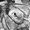
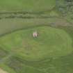
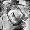
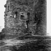
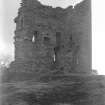
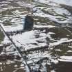
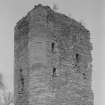
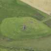
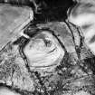
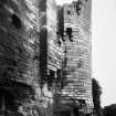
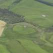
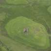
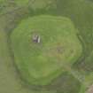
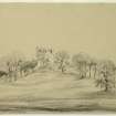
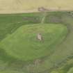
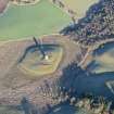
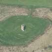
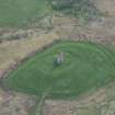
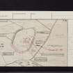
The fragmentary remains stand on high ground surrounded by bog. The castle has been oblong on plan, some 40 x 27ft. over walls averaging 6ft. in thickness. Only the south and east walls remain, rising to a height of fully 50ft. The masonry consists of coursed rubble, excepting at the angles, which are rounded and built with dressed ashlar.
Corsbie is said to have been the property of the Cranstouns of Oxenford from an early period till the middle of the 17th century. The ruins of the existing building date from the 16th century.
RCAHMS 1915.
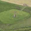
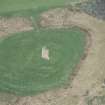
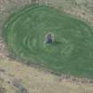
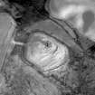
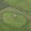
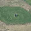
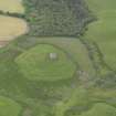
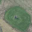
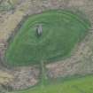
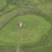
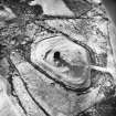
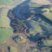
The remains of the tower are situated on a raised piece of ground, and surrounded on all sides by a bog.
A series of ramparts and ditches have enclosed the site.
Visited by OS (JD) 20 May 1955.
Only the SW and NW walls of the tower remain. The raised ground on which it stood is defended by a rampart and ditch at the base of the slopes on the SW side; and the tower itself appears to have been surrounded by another rampart with inner ditch, of which only stretches to the south and west remain. The area surrounding the tower is much mutilated and may contain the remains of ramparts too vague for identification. Immediately to the SW of the west angle of the tower is the outline of a possible outbuilding. The only approach to the tower is from the north where a causeway leads across the marshy ground up on to the raised ground.
Revised at 1:2500. (earthworks).
Visited by OS (WDJ) 18 November 1963.
Corsbie Tower is situated on a prominent knoll in marshy ground. The immediately-surrounding area has been cultivated and contains several stone-dumps (presumably from the robbing of the tower). The slight earthworks that formerly surrounded the tower are best preserved on the SW, where they comprise inner and outer banks and a medial ditch.
Visited by RCAHMS (RJCM, JRS) 30 September 1993.
Field Visit (16 April 1912)
240. Corsbie Tower.
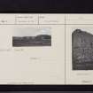
The fragmentary remains of the castle (fig.117 [SC 1173005]) stand on high ground surrounded by a bog and about 1 mile to the north-east of Legerwood Church. It has been oblong on plan, measuring some 40 feet by 27 feet over walls averaging 6 feet in thickness. Only the south and east walls remain, rising to a height of fully 50 feet. The masonry consists of carefully coursed rubble, excepting at the angles, which are rounded and built with dressed ashlar. The only surviving features are several small square-headed windows, formed in the south wall, and fragmentary indications of a wheel-stair which appears to have given direct access from the first-floor level to 'probably at least two upper floors.
Corsbie is said to have been the property of the Cranstouns of Oxenford from an early period till the middle of the 17th century; the ruins of the existing building date from the 16th century.
RCAHMS 1915, visited 16th April 1912.
OS Map: Ber., xxvi. NE.
Note (2 November 2015)
This monument was delisted and was removed from the list of buildings of special architectural or historic interest.
The structure is still designated as a scheduled monument under the Ancient Monuments and Archaeological Areas Act 1979.
Information from Historic Environment Scotland, 2 November 2015
Sbc Note
Visibility: Upstanding building, which may not be intact.
Information from Scottish Borders Council

