Sweethope Hill
Fort (Prehistoric), Settlement (Prehistoric)
Site Name Sweethope Hill
Classification Fort (Prehistoric), Settlement (Prehistoric)
Alternative Name(s) Stichill
Canmore ID 57153
Site Number NT63NE 2
NGR NT 6964 3964
Datum OSGB36 - NGR
Permalink http://canmore.org.uk/site/57153
- Council Scottish Borders, The
- Parish Stichill
- Former Region Borders
- Former District Roxburgh
- Former County Roxburghshire
The poorly-preserved remains of a prehistoric fort and settlement occupy the southern end of Sweethope Hill. The roughly circular fort comprises an inner enclosure, which is defended by two ramparts (one built around the top of the knoll on which it sits, the other enclosing the base of the knoll), and a much larger outer enclosure, which measures up to 185m in diameter and is defended by a single rampart.
Some time after the defences of the inner enclosure were abandoned, an undefended settlement was established between the ramparts at the north-east end. The settlement consists of one circular house and two scoops, which may mark the sites of timber round-houses, as well as a series of paddocks between the ramparts of the fort.
The fort was probably built and occupied in the first millennium BC, while the settlement belongs to the later prehistoric period.
Text prepared by RCAHMS as part of the Accessing Scotland's Past project
NT63NE 2 6964 3964.
Fort and Settlement, Sweethope Hill.
Sweethope Hill lies one and a quarter miles NW of Stichill and just within the county boundary. Roughly circular on plan, it consists of a broad, inclined, grassy plateau, broken by rock outcrops, which is easily accessible at its lowest point on the NE arc but is bordered by steep slopes on the NW and SE and by precipitous crags on the SW. At its higher (S) end the plateau terminates in a flat-topped knoll of irregular shape which, at a height of 731ft OD, commands an extensive view in all directions.
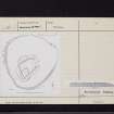
The fort (see plan, RCAHMS 1956, fig.574) comprises an inner enclosure or citadel, which occupies the area of the knoll and is defended by three ramparts, the outermost of which encloses the citadel eccentrically. The citadel measures along its axes 250ft from NE to SW by 145ft from NW to SE, while the outer enclosure is approximately seven times as large as the citadel. All the ramparts appear to have been stone-faced, but they have been drastically reduced by later occupation of the hill-top. The inner rampart, which is drawn round the summit of the knoll, has been entirely obliterated at the S corner in the construction of a plantation dyke, and elsewhere it is only represented by a low stony mound of indefinite width. The second or medial rampart encompasses the base of the knoll and is for the most part in a similarly dilapidated condition; a short length of outer facing-stones, one course high, is, however, visible on the SE side near the S corner. A hollow track which passes obliquely through these two defences on the NE may represent an original entrance, while the medial rampart possesses two other entrances, respectively on the SE and SW sides. A feature of these latter entrances is that in each case one of the rampart terminals is in-turned. The outer rampart, whose primary purpose has been to enclose more ground, probably for stock, rather than to strengthen the fortifications of the citadel, closely follows the limits of the plateau on the SW, NW, and SE sides, but is arbitrarily drawn across flat ground on the NE. On the S and SW, where it presumably ran along the edge of the crags, it has entirely disappeared, but elsewhere it is traceable by a stony mound similar in character to the other two ramparts, and lacking any definite facings. The only entrance now visible is situated on the NE side and is 10ft wide; the swollen terminals on either side of the gap are probably natural mounds which have been incorporated within the line of the rampart, though as they are both turf-covered their composition can only be determined by excavation.
No huts contemporary with the ramparts can be seen even within the innermost enclosure. The remains of a small settlement comprising a circular hut, 20ft in internal diameter, and two scoops of irregular shape, situated between the inner and medial ramparts on the NE side, are clearly intrusive since they impinge on both ramparts, as are also four short lengths of walling which define courts between the same ramparts on the N. Moreover, while all the terraces shown on the plan immediately behind the inner and medial ramparts probably originated as quarries for rampart material, the three behind the medial rampart have probably been occupied subsequently since they are covered with nettles growing in each case in a deep bed of loose dark earth. A rectangular foundation on the outer rampart in the N sector seems to be relatively recent, being associated with a small garth extending beyond the ramparts.
RCAHMS 1956, visited 22 May 1947.
As described by RCAHMS 1956
Revised at 1/2500.
Visited by OS (RDL) 26 November 1963.
Note (3 September 2015 - 21 October 2016)
This fort occupies the plateau forming the southern end of Sweethope Hill, which terminates around the S and SW in the cliffs of Sweethope Craig and is defined elsewhere on the NW and SE by steep slopes. The fort has two main elements: an inner enclosure occupying a knoll forming the summit of the hill, and a much larger enclosure that extends round the margins of the plateau. The inner enclosure is roughly trapezoidal on plan, measuring internally a maximum of 75m from NNE to SSW by 45m transversely (0.27ha), and its defences comprise an inner rampart set on the lip of the knoll and an outer rampart around its foot. Both have been heavily robbed, but the outer displays a long run of outer face on the SE. A hollowed trackway pierces both ramparts on the NE, possibly representing an original entrance, but on the SE and WSW respectively the line of the outer rampart is broken by other entrances at which the terminal on one side turns inwards to create a staggered approach exposing the visitor's right side. The outer enclosure is roughly circular on plan and measures some 195m in diameter within a single rampart which has been heavily robbed but can be traced round the margins of the plateau everywhere except above the cliffs on the S and SW. The entrance is on the NE, where the rampart cuts across the relatively level approach from this direction and appears to terminate to either side of the gap in two swollen mounds which the RCAHMS investigators in 1947 thought were probably natural features (RCAHMS 1956, 435, no.977). Apart from a later rectangular building overlying the outermost rampart on the N, the principal features visible within the interior are traces of shallow quarries to the rear of the ramparts at several points, particularly in the inner enclosure, where there is also a small late Iron Age settlement comprising at least on stone-founded round-house and several scooped courts and enclosure banks between the two ramparts. While the outermost rampart is often regarded as part of the same defensive scheme those of the inner enclosure, it is perhaps more likely to represent the remains of a free-standing enclosure.
Information from An Atlas of Hillforts of Great Britain and Ireland – 21 October 2016. Atlas of Hillforts SC3392
Sbc Note
Visibility: This is an upstanding building.
Information from Scottish Borders Council.


