
Ancrum


Settlement (Iron Age)
Site Name Ancrum
Classification Settlement (Iron Age)
Canmore ID 57125
Site Number NT62SW 45
NGR NT 6173 2415
Datum OSGB36 - NGR
Permalink http://canmore.org.uk/site/57125


- Council Scottish Borders, The
- Parish Ancrum
- Former Region Borders
- Former District Roxburgh
- Former County Roxburghshire
NT62SW 45 6173 2415.
(NT 6173 2415) Earthwork (NR) (site of)
OS 6"map, (1971).
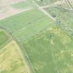
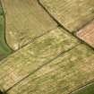
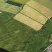
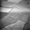
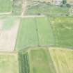
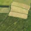
Settlement (site), Ancrum: Aerial photography reveals a circular settlement enclosed by two ditches. There are evident signs of disturbed ground over most of the interior and, in addition, at least ten house-sites appear on the gentle slope outside the enclosure.
Visible on air photographs AAK 34, AKJ 4 (CUCAP) and RAF CPE/Scot/315: 4217-8.
J K St Joseph 1967.
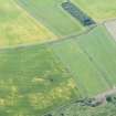
At this site, just below the crest of a gentle S-facing slope, are vague traces of the ploughed-down bank of an earthwork, enclosing a slightly sunken area about 108m in diameter. There are no traces of any ditches. As suggested by Dr St Joseph, the dark patches on the aerial photographs SE of the enclosure would appear to indicate hut platforms, but only the vaguest indentations on the ground can now be seen.
Site surveyed at 1:2500.
Visited by OS(WDJ) 27 January 1967.
Note (2 September 2015 - 18 May 2016)
Cropmarks have revealed the site of a fort situated on a broad terrace immediately above the point where the slope begins to quicken, falling away SE down to the N bank of the River Teviot. Slightly oval on plan, its defences comprise two concentric ditches about 5m in breadth and set between 6m and 10m apart, and traces of the scar of the inner rampart about 6m wide can be traced around two thirds of the circuit, petering out beneath the field dyke on the NE. This scar probably accounts for the depression noted marking the interior noted by the OS, though it cannot be as large as their measurement of 108m. Indeed, allowing for the rampart, the interior measures a maximum of 65m in diameter (0.33ha). No clear features are visible within the interior, and neither is the entrance clearly defined, by default probably lying on the SE.
Information from An Atlas of Hillforts of Great Britain and Ireland – 18 May 2016. Atlas of Hillforts SC3387
Sbc Note
Visibility: This site is visible as a cropmark.
Information from Scottish Borders Council

