
Knowesouth, Dovecot


Dovecot (18th Century)
Site Name Knowesouth, Dovecot
Classification Dovecot (18th Century)
Alternative Name(s) Knowe South, Dovecot
Canmore ID 57118
Site Number NT62SW 39
NGR NT 60683 21419
Datum OSGB36 - NGR
Permalink http://canmore.org.uk/site/57118


- Council Scottish Borders, The
- Parish Bedrule
- Former Region Borders
- Former District Roxburgh
- Former County Roxburghshire
NT62SW 39 60683 21419
(NT 6068 2141) Dovecot (NAT).
OS 6"map, (1957).
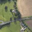
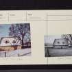
A rectangular double-chambered dovecot with walls of rubble sandstone, 3ft thick, and crow-stepped gables.
The slate-covered lean-to roof has two dormer windows.
It is still used by pigeons.
A N Robertson Mss.
As described by Robertson.
Visited by OS(WDJ) 27 January 1967.
Large rectangular double-chambered doocot, rubble-built with crowstepped gables. A slate-covered lean-to roof features 2 dormer windows.
Sbc Note
Visibility: This is an upstanding building.
Information from Scottish Borders Council.

