
Begbie


Fort (Period Unassigned), Geological Cropmark(S) (Period Unknown), Pit(S) (Period Unassigned)
Site Name Begbie
Classification Fort (Period Unassigned), Geological Cropmark(S) (Period Unknown), Pit(S) (Period Unassigned)
Canmore ID 56520
Site Number NT57SW 31
NGR NT 50043 70752
Datum OSGB36 - NGR
Permalink http://canmore.org.uk/site/56520


- Council East Lothian
- Parish Haddington
- Former Region Lothian
- Former District East Lothian
- Former County East Lothian
NT57SW 31 NT 50043 70752
(NT 5001 7079) Enclosure (NR) (site of)
OS 6" map (1969)
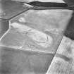
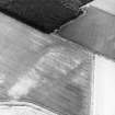
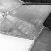
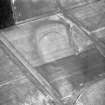
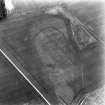
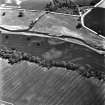
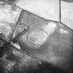
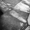
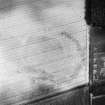
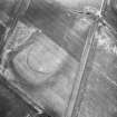
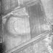
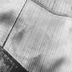
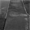
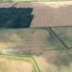
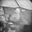
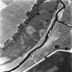
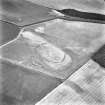
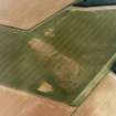
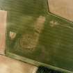
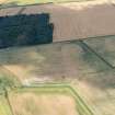
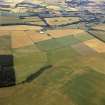
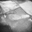
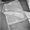
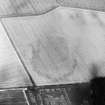
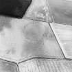
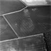
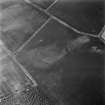
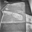
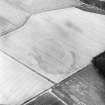
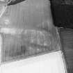
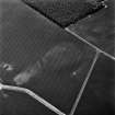
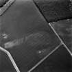
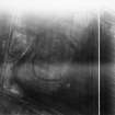
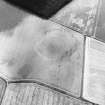
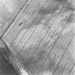
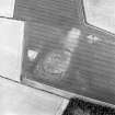
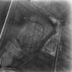
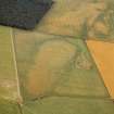
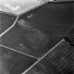
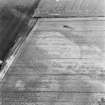
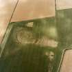
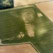
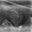
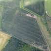
This oval enclosure with a single ditch is visible as a cropmark and measures about 350ft E-W by 280ft. It lies in a loop formed by an old stream bed and has an entrance at the E end facing open ground (aerial photographs CPE/Scot/UK257: 3152-3).
RCAHMS Marginal Lands MSS 1954
Dr St Joseph considers this site, which is on a glacial mound, to be an enclosed settlement.
J K St Joseph 1967
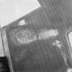
There is no visible evidence of any feature at this site, nor is there any local knowledge of any finds in the area.
Visited by OS (BS) 8 July 1975
Visible on CUCAP and RCAHMS air photographs.
(Undated) information in NMRS.
Aerial Photographic Interpretation (1 June 1954)
Enclosure, Begbie Wood (Haddington).
An oval enclosure with a single ditch in the larger of the two fields that adjoin the N corner of Begbie Wood. The enclosure, which measures approximately 350 ft from E to W by 280 ft transversely, lies in the loop formed by an old stream bed and has an entrance at the E end facing open ground.
(1) CPE/Scot/UK/257, 3147-8.
Information from RCAHMS (KAS) 1 June 1954.
Reference (1957)
This site is noted in the ‘List of monuments discovered during the survey of marginal land (1951-5)’ (RCAHMS 1957, xiv-xviii).
Information from RCAHMS (GFG), 24 October 2012.
Geophysical Survey (August 2000 - January 2002)
Geomagnetic surveys have been carried out over a sample of 30 cropmark sites in the vicinity of Traprain Law, comprising Phase 1 of the Traprain Law Environs Project.
In the majority of cases (23 out of 30), the surveys have confirmed the presence on the ground of the enclosures shown on aerial photographs, often with very clear results. In a number of cases, the surveys have produced evidence of probable internal and/or external features which were not immediately visible on air photographs, while in other cases, the presence of these additional features has been confirmed. Several of the sites investigated appear to represent more than one phase of archaeological activity.
In the 7 cases where cropmark sites have not been readily identified, this appears to be due to a number of factors. In only one instance does the underlying igneous geology appear to be the main factor; while in several cases, anomalies not immediately relatable to the previous cropmarks were detected and might well prove be of archaeological significance.
The work reported here brings to a conclusion Phase 1 of the Traprain Law Environs Project.
Archive to be deposited in the NMRS.
Sponsors: Historic Scotland, University of Durham, and Dickinson College, Pennsylvania.
Duncan Hale and Colin Haselgrove.
Project (2000 - 2004)
A project investigating the nature and development of later prehistoric and Roman Iron Age settlement in a 15 by 10 km block of landscape around the major fortified hilltop site at Traprain Law in East Lothian.
Note (18 December 2015 - 20 October 2016)
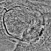
Cropmarks have revealed the site of a fort situated on a low rise in the broad floor of the Tyne valley ESE of Begbie. Oval on plan, its defences are only clearly defined at either end, comprising an inner ditch some 6m in breadth with three narrower ditches on the W, and two on the E. Thus defined, it measures about 105m from ENE to WSW by 80m transversely (0.65ha), and allowing for the presence of an inner rampart, the interior would have extended to about 0.52ha. The inner ditch, however, does not form a continuous circuit and it is particularly noticeable that on both the aerial photographs and a geophysical survey prepared in 2002 that the extended line of the W arc peters out on the N inside the line of the E arc. The discrepancy does not appear to be an elaborate entrance, and suggests either that the E arc is an internal quarry rather than an external ditch, or that this impression has been created by the eccentric superimposition of several phases of enclosure, this latter interpretation might also explain why the ditches are closely concentric on the WSW, but more wide-spaced on the ENE, there lying up to 10m apart. There are also two causeways across the inner ditch at this end, one on the ENE and the other on the E, the northern of which seems to correspond with gaps in the two outer ditches. On the N traces of a palisade trench are visible about 5m within the innermost ditch, but no coherent structures can be resolved from the other marks that can be seen scattered across the interior.
Information from An Atlas of Hillforts of Great Britain and Ireland – 20 October 2016. Atlas of Hillforts SC3884

