
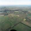
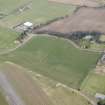
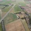
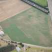
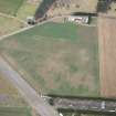
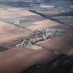
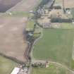
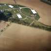
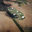
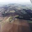
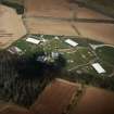
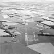
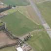
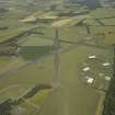
East Fortune Airfield, Technical Area


Air Raid Shelter(S) (Second World War) (1939)-(1945), Airfield (20th Century), Airship Station (First World War), Military Airfield (First World War), Military Airfield (Second World War), Museum (20th Century), Racing Circuit (20th Century)
Site Name East Fortune Airfield, Technical Area
Classification Air Raid Shelter(S) (Second World War) (1939)-(1945), Airfield (20th Century), Airship Station (First World War), Military Airfield (First World War), Military Airfield (Second World War), Museum (20th Century), Racing Circuit (20th Century)
Alternative Name(s) East Fortune Airship Station; Museum Of Flight; East Fortune Aerodrome; National Museums Scotland
Canmore ID 56276
Site Number NT57NE 72
NGR NT 55565 78959
NGR Description Centred NT 55565 78959
Datum OSGB36 - NGR
Permalink http://canmore.org.uk/site/56276


- Council East Lothian
- Parish Athelstaneford
- Former Region Lothian
- Former District East Lothian
- Former County East Lothian
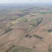
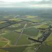
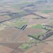
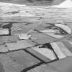
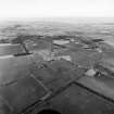
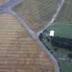
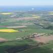
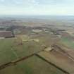
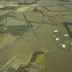
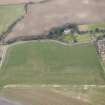
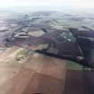
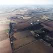
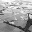
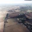
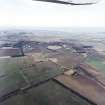
The military airship station and aerodrome at East Fortune was opened in August 1916 as one of a series of bases for airships and aeroplanes to protect shipping in the North Sea from German submarines. It became the most extensive air station in Scotland, with an area of 540 hectares, of which 28 hectares was occupied by buildings. Not all of the remaining land was suitable for aeroplane landings, however, and in 1918 it was noted that some of the station’s area was under cultivation.
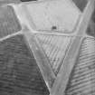
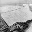
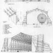
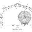
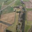
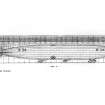
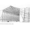
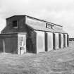
The station was dominated by three massive airship sheds. Two, for non-rigid ‘Coastal’ type airships, were built in 1916 and measured 97m by 36m and 24m high. They had wind-screens at both east and west ends. The third airship shed, dwarfing even the first two (at 213m by 55m and 34m high), was built in April 1917 to house the early machines of the new rigid airship fleet. It was set between but slightly to the west of the first two, their bulk acting to screen an airship emerging from east end of the largest shed from cross-winds. It also had a wind-screen at its west end.
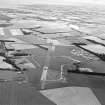
The fixed wing aircraft part of East Fortune was opened at the same time as the airship base. Throughout 1916 it was the main Royal Naval Air Service aerodrome in Scotland, being used for training and for flying patrols over the approaches to the Firth of Forth. At the end of 1916 the aerodrome is recorded as having 17 duty pilots, with a smaller number of aircraft, only a handful of which might be operational. The operational strength had risen to about 40 aircraft by the beginning of 1918.
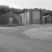
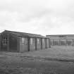
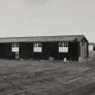
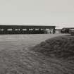
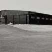
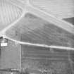
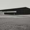
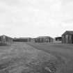
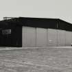
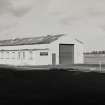
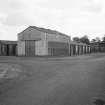
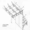
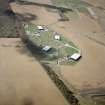
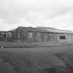
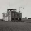
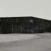
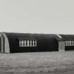
The First World War aerodrome’s technical buildings and all the accommodation for the base were concentrated in the northern half of the site. The airship station was equipped with a full range of supporting structures and facilities: a power station, a gas-producing plant for the airships, workshops for the maintenance of airships and aeroplanes, and extensive accommodation for its personnel. The number of personnel on the airship station was not recorded. The aeroplanes of the base were housed in three large aeroplane hangars at the eastern end of the range of buildings (one 61m by 30.5m and two 36.5m by 30.5m), and a further eight canvas Bessoneaux hangars measuring 20m square.
By the time of the RAF survey of aerodrome stations in 1918 East Fortune had become the base of 201 Training Squadron, the role of which was to train torpedo plane pilots, 40 at a time. The establishment of this part of the station was 261, of whom 36 were women.
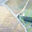
The main east coast railway line ran through the station and rail sidings extended as far as the gas-producing plant.
On 2 July 1919 the rigid airship R34, built at the Inchinnan Works near Glasgow, left East Fortune on the first east to west crossing of the Atlantic.
The aerodrome was closed in 1920 but the land was re-acquired during the Second World War, in 1940, as a satellite to Drem, becoming fully operational in 1941.
Many of the buildings along the public road that crossed the site from east to west were re-used after the First World War in what became East Fortune hospital: most can be identified - the lecture hall of the station; the officers’ servants’ quarters; the Warrant Officers’ office; the sick bay and first aid station; a garage; and 13 out of 14 barrack huts and their central catering hall (see NT57NE 106).
Information from HS/RCAHMS World War One Audit Project (GJB) 12 June 2013.
NT57NE 72.00 centred 55565 78959
Airfield also falls on map sheet see also NT57NW 181.00
NT57NE 72.01 NT 55094 79196 Workshop
NT57NE 72.02 NT 55092 78277 Building
NT57NE 72.03 NT 5545 7771, 5575 7767, 5530 7740 and NT 5565 7745 Military Camps
NT57NE 72.04 NT 55065 78293 Water Tank
NT57NE 72.05 NT 55100 78346 Aircraft Hangar
NT57NE 72.06 NT 55265 78235 Aircraft Hangar
NT57NE 72.07 NT 55074 78215 Workshop
NT57NE 72.08 NT 55091 78178 Store
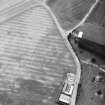
NT57NE 72.09 NT 54952 78686 Control Tower
NT57NE 72.10 NT 55225 78201 Building
NT57NE 72.11 NT 55050 78152 Store
NT57NE 72.12 NT 5583 7815 Bomb Store
See also NT57NW 181.00 to NT57NW 181.13 for rest of Airfield buildings.
See also NT57NE 106 for part of the First World War airfield buildings which were converted to East Fortune Hospital post 1920.
East Fortune airship station was established in 1915-16 as a major element of the strategic network protecting the British coastline, and, as such, was intended the accommodate the larger 'Coastal' or 'North Sea' types of non-rigid craft as well as those of the embryo rigid fleet. Accommodation at such stations typically comprised a rigid-airship shed flanked on each side by a smaller 'coastal' shed, these being stepped forward forward to afford a sheltered area in front of the rigid shed. The assemblage was aligned with the direction of the prevailing wind. Typically, the a Coastal shed measured 320 ft (97.54m) by 120 ft (36.58m) by 80 ft (24.38m) while the rigid sheds extended to as much as 700 ft (213.36m) and 110 ft (33.53m) in clear height. That at East Fortune, however, measured 180 ft (54.86m) in width, so as to be able to house two of the larger 33-class rigids. The rigid shed at East Fortune was apparently comparable to the No. 2 shed at Pulham, Norfolk.
After July 1917, the East Fortune shed was also used as the main base for the 'North Sea' class.
G D Hay and G P Stell 1986.
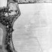
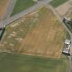
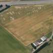
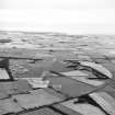
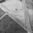
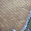
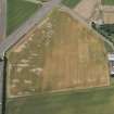
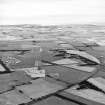
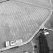
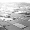
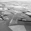
Air photographs (RCAHMSAP 1991) have revealed cropmarks of various features relating to the airship station and airfield. The probable remains of the R34 airship shed and the coastal sheds lie at NT 551 790 with the associated windbreak (shown as parallel pairs of small circular features running to the W of the sheds) running from NT 547 789 to NT 549 790. These are shown on the RNAS East Fortune external mains plan c.1918 (held in the National Museums of Scotland, Museum of Flight). The top of the rigid airship shed was removed c.1926 but the concrete base remained for later use and is visible on RAF Air Photographs taken in 1946 (106G/SCOT/UK14 5363-5364) and 1952 (540/718 4283-4284). Other cropmarkings include a semi-circular mark at NT 550 786 which was probably an Immediate Readiness Dispersal area (Quick Reaction Dispersal) on the later airfield. Similar marks are visible at NT 560 791 and NT 558 786 on 1946 Air Photographs (106G/SCOT/UK14 5364).
Information from RCAHMSAP (RHM), 15 February 1994
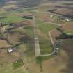
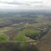
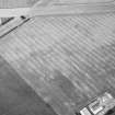
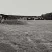
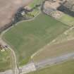
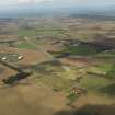
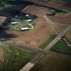
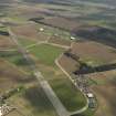
The hangars of this airfield now hold the collections of the Museum of Flight (a constituent body of the National Museums of Scotland). The runway area is used as a motor racing circuit and for a Sunday market.
Information from RCAHMS (RJCM), 16 October 1996
Airfield with many runways and buildings extant, now in use by the Museum of Flight.
J A Guy 1997; NMRS MS 810/5, 156-63
NT 555 782 (centre) A watching brief was undertaken at East Fortune Airfield (NMRS NT57NE 72) during pipe-laying work, which crossed the Scheduled area of the airfield. A quantity of massive concrete blocks were discovered in the vicinity of the now-demolished airship base, possibly representing the remains of one of the associated structures.
Sponsor: East and Midlothian NHS Trust.
B Glendinning 1998
NT 549 787 Between the 31st of March and the 1st od April 1998 the Centre for Field Archaeology (CFA) carried out a watching brief at East Fortune Airfield. The work was commissioned by East and Midlothian NHS Trust, due to the excavation of a pipe track across the scheduled area. Scheduled Monument Consent was granted for the work by Historic Scotland. Trenching was carried out by a JCB, although in the most N part of the trench a 360degree excavator was used. The section of the pipe track running from the Museum of Flight to runway crossing 4 had been excavated and backfilled before the CFA had been notifed of the works being started. Also, the section between runway crossing 1 and crossing 2 had been excavated and had just started to be backfilled before the CFA were informed.
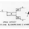
An examination of what remained of the pipe track between crossings 1 and 2 revealed a jumble of massive concrete blocks streching along the length of the track. Mixed in amongst the concrete was a lot of blasting wire. Some of these blocks were L-shaped and were presumably debris from a demolished structure. Most of the blocks had square cross section with sides 0.51m by .37m. The runway had been built over the top of this demolition debris and it is possible that this material came from the demolition of the airship station which had been formerly located in this part of the airfield.
The section of pipe track between runway crossings 2 and 4 was watched during its excavation. The path from the runway to the Control tower was found to be a great deal wider than is presently mapped, 8m rather than 2m. This path was found to be undergoing great damge through ploughing of its edges. It consisits of a rubble base with a layer of Tarmac over this. Some traces of the wiring system that ran between runway and control tower was identified running through the trench.
No artefacts were recovered in the trenches and it was concluded that no further work is required on site.
Sponsor: East and Midlothian NHS Trust
NMRS MS/726/137 (CFA)
NT 557 785 A watching brief was carried out in May 2003 on the construction of a new section of motor bike racing track within the confines of the Scheduled East Fortune Airfield. No significant archaeological features or finds were observed.
Archive to be deposited in the NMRS.
Sponsor: Melville Motor Club.
G Carruthers 2003
The airfield is visible on RAF WW II vertcial air phtographs (NLA 68, 3041-3049,4041-4049, flown 26 August 1943), which show the area of the Museum of Flight before the installation of the fourth aircraft hangar.
Information from RCAHMS (DE), March 2005
Watching Brief (31 March 1998 - 1 April 1998)
NT 555 782 (centre) A watching brief was undertaken at East Fortune Airfield (NMRS NT 57 NE 72) during pipe-laying work, which crossed the Scheduled area of the airfield. A quantity of massive concrete blocks were discovered in the vicinity of the now-demolished airship base, possibly representing the remains of one of the associated structures.
Sponsor: East and Midlothian NHS Trust.
B Glendinning 1998
Watching Brief (May 2003)
NT 557 785 A watching brief was carried out in May 2003 on the construction of a new section of motor bike racing track within the confines of the Scheduled East Fortune Airfield. No significant archaeological features or finds were observed.
Archive to be deposited in the NMRS.
Sponsor: Melville Motor Club.
G Carruthers 2003
Project (March 2013 - September 2013)
A project to characterise the quantity and quality of the Scottish resource of known surviving remains of the First World War. Carried out in partnership between Historic Scotland and RCAHMS.
Note (29 October 2021)
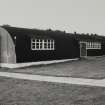
The Pillbox Study Group recorded at least 12 air raid shelters of either Stanton type or blast shelters around the airfield depicted on the OS 1:2500 map (1965). These were located at NT 5578 7935, NT 5583 7940,NT 5584 7942, NT 5614 7874, NT 5582 7846, NT 5579 7843, NT 5576 7837, NT 5469 7810, NT 5439 7809, NT 5444 7809, NT 5447 7807 and NT 5433 7873. Examination of recent vertical photograph suggests that all of these have been demolished.
Information from Pillbox Study Group and HES (AKK) 29 October 2021

