
East Linton


Fort (Prehistoric)
Site Name East Linton
Classification Fort (Prehistoric)
Canmore ID 56215
Site Number NT57NE 17
NGR NT 58515 76552
Datum OSGB36 - NGR
Permalink http://canmore.org.uk/site/56215


- Council East Lothian
- Parish Prestonkirk
- Former Region Lothian
- Former District East Lothian
- Former County East Lothian
NT57NE 17 NT 58515 76552
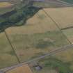
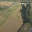
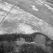
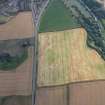
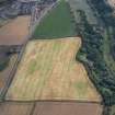
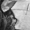
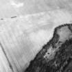
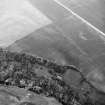
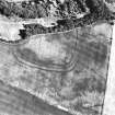
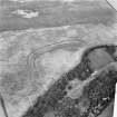
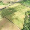
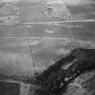
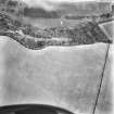
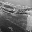
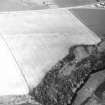
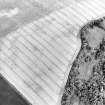
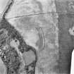
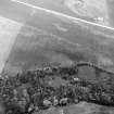
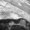
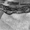
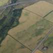
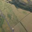
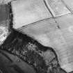
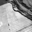
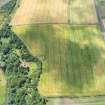
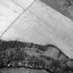
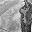
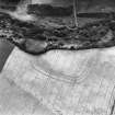
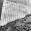
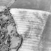
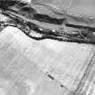
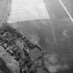
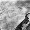
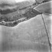
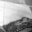
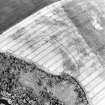
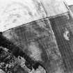
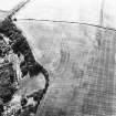
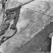
NT 585 765. Aerial photographs (RAF/CPE/Scot/UK257: 4119-20; CUCAP) reveal a triple-ditched rectilinear enclosure (?fort) as crop marks in a cultivated field, N of the River Tyne 1/2 mile SW of East Linton.
Having more or less straight sides and rounded angles, it measures internally about 400ft by 200ft along the axes; the ditces are close-set and there is no trace of an entrance. Air photographs also show 'what appears to be a narrow ditch in the interior, running from N to S and cutting off the NE corner.' There are no traces of internal buildings. (This site is listed by Maxwell among a number of enclosures which he compares with Iron Age timber-house sites on the Northumberland coastal plain).
G Maxwell 1970; RCAHMS Marginal Lands MSS
NT 5851 7655. No trace of this feature was seen on the ground. The site lies in a gently sloping arable field, the ground falling away abruptly along the hedge-line on the S side of the site.
Visited by OS (WDJ) 24 October 1962
Further aerial photographs have been taken by the RCAHMS and by CUCAP.
(Undated) information in NMRS.
Aerial Photographic Interpretation (25 June 1954)
FORT, EAST LINTON.
National Survey air-photographs (1) reveal the triple ditches of part of an unrecorded fort as crop markings in a cultivated field on the N bank of the River Tyne half a mile SE of East Linton. The fort occupies a level situation on the brink of a steep escarpment overlooking the river, and its S portion has been destroyed by landslips. All that survives is the N side, 400 ft in length, and parts of the W and E sides, respectively 280 ft and 50 ft in length. The corners are rounded and the N and W sides more or less straight and at right angles to one-another, so that at first glance a Roman origin seems possible for this work. On the other hand the three ditches are not precisely parallel, the outermost ditch on the N side being distinctly curved; the radii of the curves of the NE and NW corners are greater than is usual in the case of Roman forts; and there are no entrance- gaps through the ditches. Low level oblique air photographs of the site taken by Dr St. Joseph (2) show what appears to be a narrow ditch in the interior running from N t o S. and cutting off the NE corner, but neither group of photographs exhibits any trace of internal buildings.
(1) CPE SCOT UK 257, 4119 - 20.
(2) Nos. RF 84-6 in the CUCAP.
Information from RCAHMS (KAS) 25 June 1954.
Reference (1957)
This site is noted in the ‘List of monuments discovered during the survey of marginal land (1951-5)’ (RCAHMS 1957, xiv-xviii).
Information from RCAHMS (GFG), 24 October 2012.
Aerial Photographic Transcription (8 December 1995 - 15 January 1998)
An aerial transcription was produced from oblique aerial photographs. Information from Historic Environment Scotland (BM) 31 March 2017.
Geophysical Survey (August 2000 - January 2002)
Geomagnetic surveys have been carried out over a sample of 30 cropmark sites in the vicinity of Traprain Law, comprising Phase 1 of the Traprain Law Environs Project.
In the majority of cases (23 out of 30), the surveys have confirmed the presence on the ground of the enclosures shown on aerial photographs, often with very clear results. In a number of cases, the surveys have produced evidence of probable internal and/or external features which were not immediately visible on air photographs, while in other cases, the presence of these additional features has been confirmed. Several of the sites investigated appear to represent more than one phase of archaeological activity.
In the 7 cases where cropmark sites have not been readily identified, this appears to be due to a number of factors. In only one instance does the underlying igneous geology appear to be the main factor; while in several cases, anomalies not immediately relatable to the previous cropmarks were detected and might well prove be of archaeological significance.
The work reported here brings to a conclusion Phase 1 of the Traprain Law Environs Project.
Archive to be deposited in the NMRS.
Sponsors: Historic Scotland, University of Durham, and Dickinson College, Pennsylvania.
Duncan Hale and Colin Haselgrove.
Project (2000 - 2004)
A project investigating the nature and development of later prehistoric and Roman Iron Age settlement in a 15 by 10 km block of landscape around the major fortified hilltop site at Traprain Law in East Lothian.
Archaeological Evaluation (September 2003 - October 2004)
The Traprain Law Environs Project is investigating the settlement and economy of the landscape around Traprain Law during the 1st millennia BC and AD (see DES 2003, 60-61). Since 2000, geophysical surveys have been conducted on 30 cropmark sites, which have been followed up by a series of evaluation trenches and open area excavations.
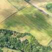
NT 58 51 East Linton. A smaller excavation also took place across the multi-vallate enclosure at East Linton. A trench recorded sections through the three enclosure ditches. The innermost ditch was c 4m wide and 1.6m deep, the outer two ditches 3m wide and 1.2m in depth. A palisade was also recorded between the inner and central ditch. Each of the ditches had been recut at least once.
Archive to be deposited in the NMRS.
Sponsors: HS, British Academy, Society of Antiquaries of Scotland.
P Carne, D Hale and C Haselgrove 2004.
Note (14 December 2015 - 18 May 2016)
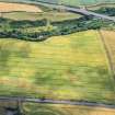
This fort is situated on a terrace immediately above the steepest and highest part of the escarpment forming the N side of the River Tyne gorge. The plan of the fort is unusual with rounded angles on the NNE and WNW giving a rectilinear outline on the WSW, NNW and a short length of the adjacent ENE side, but to the SE the lip of the gorge cuts diagonally across it, reducing the overall shape to something more akin to a triangle measuring 140m from ENE to WSW by a maximum of 100m transversely (1.1ha) within three concentric ditches. The latter are between 3m and 4m in breadth, forming a belt about 20m deep, and allowing for the presence of an inner rampart the interior would have extended to about 1ha. The only clear feature within the interior is a minor ditch possibly forming an enclosure at the E end, though a geophysical survey may show it traversing the belt of defences. This survey has revealed the plan in greater detail than the cropmarks, including two entrances in the WSW side, the southern with staggered gaps that create an oblique approach exposing the visitor's right side; the northern entrance is more ragged, the gaps in the inner and middle ditches staggered to expose the left side, but not matched by the gap in the outer ditch. The survey also confirmed a gap in the middle ditch on the NNW, and the presence of a palisade trench between the inner and middle ditches, which is apparently continuous across the northern of the two entrances in the WSW side and, slightly more contentiously, possibly turns outwards through the southern. These hints that the perimeter is multiperiod is to some extent confirmed in an evaluation trench excavated in 2004 (Haselgrove and Hale 2009, 109-14), in which the ditches, the largest some 1.6m deep, provided evidence of re-cutting. Two radiocarbon samples, one from a carbonised seed in the inner ditch, and another from birch charcoal in the palisade trench produced dates in the final centuries of the 2nd millennium BC, while birch charcoal from the middle ditch was dated 390-200 BC. While it is possible that there is a major Bronze Age enclosure here, it is equally clear that many of the Iron Age enclosures recorded by cropmarks along the Lothian Plain are occupying the sites of unenclosed Bronze Age settlements, and that the Iron Age deposits often contain residual material. In the present state of knowledge, the single Iron Age date from this evaluation is likely to be a more reliable guide to the chronology of the defences at East Linton than the two earlier ones.
Information from An Atlas of Hillforts of Great Britain and Ireland – 18 May 2016. Atlas of Hillforts SC3870

