
Grizzlefield, East Rings


Fort (Prehistoric)
Site Name Grizzlefield, East Rings
Classification Fort (Prehistoric)
Canmore ID 55943
Site Number NT54SE 6
NGR NT 5924 4014
Datum OSGB36 - NGR
Permalink http://canmore.org.uk/site/55943


- Council Scottish Borders, The
- Parish Earlston
- Former Region Borders
- Former District Ettrick And Lauderdale
- Former County Berwickshire
NT54SE 6 5921 4015
(NT 5921 4015) Earthwork (NR) (site of)
OS 6" map (1968).
Not to be confused with West Rings fort (NT 5883 4012), for which see NT54SE 7.
The remains of this 'fort' lie some 300 yds E of that described on NT54SE 7, on the E end of the same ridge and at a height of some 600ft OD. It has been oval in form, measuring internally some 590ft by 369ft, surrounded by a single earthen rampart with an external ditch, both now much defaced.
J Tait 1885; RCAHMS 1915.
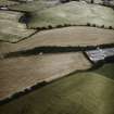
No trace of any earthwork in a ploughed field. Situated on a low-lying ridge, this earthwork would appear to have been non-defensive.
Visited by OS (JD), 20 May 1955.
No trace of this earthwork was seen in a pasture field during field perambulation. Sited to NT 5921 4015 from information above and from field inspection of ridge.
Visited by OS (WDJ), 10 October 1962.
This site has been photographed from the air by Mr J Forsyth, who gives a grid reference of NT 595 401.
Information from J Forsyth, Dept of Educational Resources, Borders Regional Council, Newtown St Boswells, 25 September 1979.
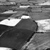
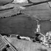
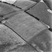
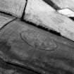
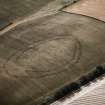
Fort, Grizzlefield East Rings. Photographed by the RCAHMS in 1979.
Additional air photographs taken by the RCAHMS in 1980, 1981, 1982, 1983, 1986, 1989, 1990, 1993, 1994 and 1996.
(Undated) information in NMRS.
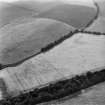
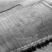
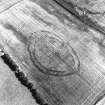
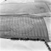
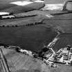
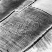
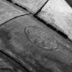
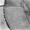
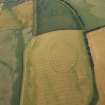
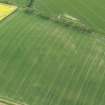
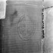
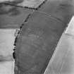
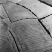
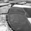
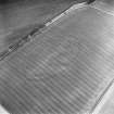
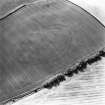
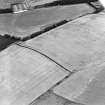
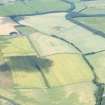
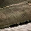
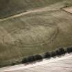
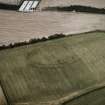
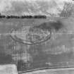
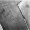
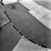
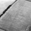
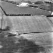
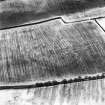
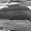
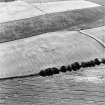
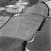
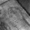
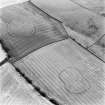
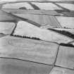
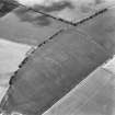
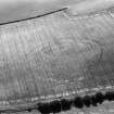
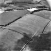
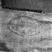
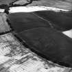
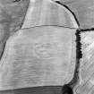
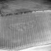
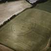
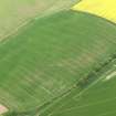
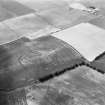
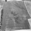
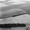
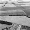
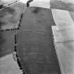
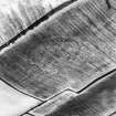
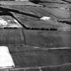
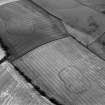
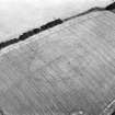
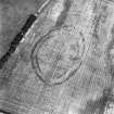
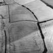
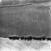
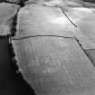
This fort has been recorded as cropmarks on oblique aerial photography (RCAHMSAP 1979, 1980, 1981, 1982, 1983, 1986, 1989, 1990, 1993, 1994, 1996, 1997, 1998, 2000) lying on a ridge about 620m ENE of Grizzlefield. It is oval on plan measuring about 140m from E-W by about 95m within two ditches about 10m apart with entrances on the E and W. There is a gap in the outer ditch on the S, though whether this is matched in the inner ditch is obscured by an irregular macular cropmark. There are probably several roundhouses recorded as roughly macular cropmarks. Ditches describing a shallow curve and an L-shape can be seen in the interior. Parallel ditches running E to W across the fort may belong to a ploughed-down field boundary.
Information from RCAHMS (KMM), 19 August 2004.
Field Visit (May 1911)
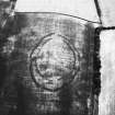
134. Fort, Grizzlefield ‘East Rings’.
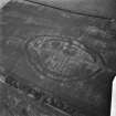
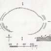
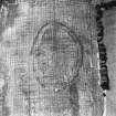
The remains of this fort (fig. 74 [DP 229123]) lie some 300 yards to the east of the last on the east end of the same ridge, and at an elevation of some 600 feet over sea-level. It has been oval in form, measuring interiorly some 590 feet by 369 feet and surrounded by a single rampart of earth with a trench to the outside, both now much effaced.
See Ber. Nat. Club, 1882-84, p, 309.
RCAHMS 1915, visited May 1911.
O.S.M , Ber., xxvi. SE. (unnoted).
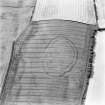
Aerial Photographic Transcription (7 September 1993 - 19 April 1994)
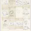
An aerial transcription was produced from oblique aerial photographs. Information from Historic Environment Scotland (BM) 31 March 2017.
Note (16 January 2016 - 4 August 2016)
This fort is situated on the E end of a low ridge and is the eastern of two no more than 250m apart that stood to the ENE of Grizzelfield (see Atlas No.4006). First noted on the Map of the County of Berwick surveyed by Andrew and Mostyn Armstrong in 1771, it was ploughed down in the first half of the 19th century, but cropmarks have revealed that the defences comprise two circuits of ditches, and the remains of the rampart accompanying the outer was still visible when James Hewat Craw drew up a plan in 1911 (RCAHMS 1915, 76, no.134, fig 74). The interior is oval, measuring about 130m from E to W by 90m transversely (0.9ha) within the inner ditch, and allowing for the presence of an internal rampart it would have enclosed about 0.78ha. At 6m in average breadth, however, the outer ditch is rather broader than the inner, and while they are roughly concentric, generally lying some 5m to 10m apart, there is no particular reason to assume that they represent a contemporary scheme of defence. Indeed, as at nearby West Morriston (Atlas No.4004), where likewise traces of the outer rampart survived into the early 20th century but without any hint of the inner circuit, the outer may well represent a larger free-standing enclosure in its own right, measuring up to 170m from E to W by 100m transversely (1.3ha). If this is the case, the dogleg outwards on the E, which sharply increases the gap between the two circuits to 20m at this end, was a simple device to increase the size of the interior. Alternatively it was to elaborate the entrance here, complicating the approach to the two causeways that cross the inner ditch some 20m apart; the southern of these causeways, and the one more directly opposed to the gap in the outer ditch, appears to have been narrowed with palisade trenches springing from the terminals of the ditch to either side. No such elaboration occurs at the W entrance, where there is a very slight stagger in the terminals of the outer ditch and apparently a gap 20m wide in the inner, but at the third entrance, on the S, not only are the outer ditch terminals slightly staggered, but a dark mark extending across both lines of defence suggests the presence of a worn entrance way approaching obliquely to expose the visitor's right side. Within the interior three or four maculae are visible in the SE quarter, one of which is clearly the remains of a timber round-house. The only other features are a right-angled length of ditch which appears to have formed an enclosure with the inner ditch on the N side, and another arc of ditch lying adjacent immediately to the E; their relationship to the inner ditch is uncertain.
Information from An Atlas of Hillforts of Great Britain and Ireland – 04 August 2016. Atlas of Hillforts SC4005
Sbc Note (21 March 2016)
Visibility: This was the site of an archaeological monument, which may no longer be visible.
Information from Scottish Borders Council

