
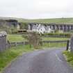
Shankend Viaduct


Railway Viaduct (19th Century)
Site Name Shankend Viaduct
Classification Railway Viaduct (19th Century)
Alternative Name(s) The Waverley Line; Langside Burn; The Border Union Railway
Canmore ID 55168
Site Number NT50NW 29
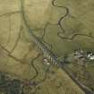
NGR NT 52144 05972
Datum OSGB36 - NGR
Permalink http://canmore.org.uk/site/55168


- Council Scottish Borders, The
- Parish Cavers
- Former Region Borders
- Former District Roxburgh
- Former County Roxburghshire
NT50NW 29 52144 05972
Shankend Viaduct [NAT]
OS 1:10,000 map, 1982.
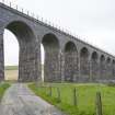
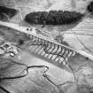
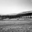
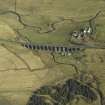
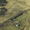
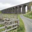
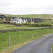
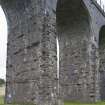
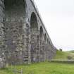
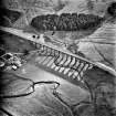
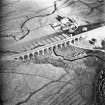
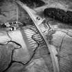
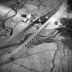
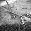
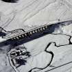
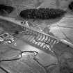
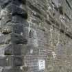
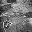
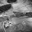
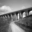
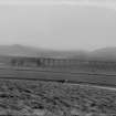
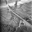
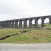
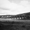
Shankend Viaduct, pre-1866. Striding structure of 15 tall arches whose landscape impact is far more formidable than its shabby close-up appearance. Redundant, 1963.
C A Strang 1994.
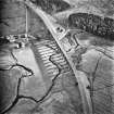
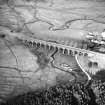
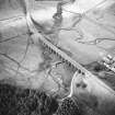
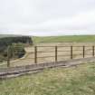
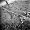
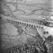
This viaduct formerly carried the Edinburgh-Carlisle main line of the North British Rly. (the 'Waverley route') across the Langside Burn, and was one of the numerous major engineering works on the route; the fifteen 35 ft (10.6m) spans were 60 ft (18.3m) high. It was built (by Ritson as contractor) with much delay, and was apparently opened to good traffic on 24 June 1862 and to passenger traffic on 1 July 1862 as part of the Riccarton Junction-Hawick section on the Border Union Rly. The Waverley route closed to regular passenger traffic on 6 January 1969.
Information from RCAHMS (RJCM), 2 February 2006.
J Thomas 1969; G Daniels and L Dench 1980.
The large fifteen arch railway viaduct at Shankend was photographically surveyed by RCAHMS as part of the Waverley Line Project during May 2010. The viaduct has recenltly been renovated by Railtrack to ensure it remains a safe structure (2008-2009) and the scaffolding has now been removed. The viaduct was not entered as part of the survey.
Visited by RCAHMS (DE, AL), 19 May 2010
Publication Account (2007)
An impressive masonry viaduct over Slitrig Water with 15x34 ft semicircular arch spans up to 35 ft high, built
from 1859 to 1862 in bleak and sparsely populated hill country for the Border Union Railway. The viaduct,
which has been extensively repaired with brick patching, formed part of the legendary North British ‘Waverley
Route’ through Sir Walter Scott country, officially opened between Edinburgh and Carlisle on 1 July 1862 and
closed in 1969. The viaduct formed part of the Whitrope contract which extended south for about 412 miles and included Whitrope Tunnel. The designer, according to the current inventory, was Charles Jopp and the contractor, William Ritson. The present owner is BRB (Residuary Ltd) who intend to waterproof the structure in 2007. In 2000 repair work of pinning, grouting and brick replacement helped to preserve the viaduct.
R Paxton and J Shipway 2007
Reproduced from 'Civil Engineering heritage: Scotland - Lowlands and Borders' with kind permission from Thomas Telford Publishers.
Sbc Note (15 April 2016)
Visibility: Standing structure or monument.
Information from Scottish Borders Council

