
Seton West Mains


Settlement (Period Unknown)
Site Name Seton West Mains
Classification Settlement (Period Unknown)
Alternative Name(s) Fishers Road; Fishers Road West; Port Seton West
Canmore ID 54934
Site Number NT47NW 24
NGR NT 40618 75251
Datum OSGB36 - NGR
Permalink http://canmore.org.uk/site/54934


- Council East Lothian
- Parish Tranent
- Former Region Lothian
- Former District East Lothian
- Former County East Lothian
NT47NW 24 NT 406183 75251
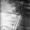
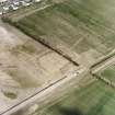
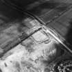
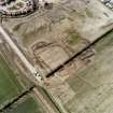
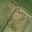
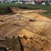
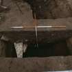
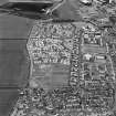
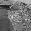
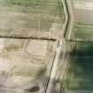
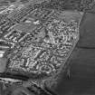
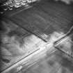
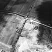
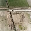
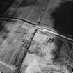
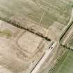
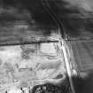
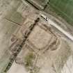
NT 406 752 Excavation by AOC (Scotland) Ltd in May and June 1994, of a cropmark revealed a sub-rectangular enclosure measuring approximately 3.5ha at its maximum extent. The limits of the enclosure were defined by a sequence of ditches. Throughout this sequence the enclosure was aligned approximately E to W, with access to the interior via causeways from both the eastern and western approaches. Within the ditch stratigraphy five phases of site activity were identified.
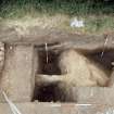
In general the site was truncated to such an extent that little evidence of sequence survived. Within the primary feature of the cropmark, the enclosing ditch, five phases of activity are apparent:
Phase 1: The earliest ditch line only survived on the SW corner of the site where it was clearly truncated by the line of the Phase 2 ditch.
Phase 2: A second shallow and much truncated ditch was detected in almost all ditch trenches. The shallowness of this feature in many areas of the site indicates either that the site suffered a considerable phase of erosion prior to Phase 3, or that it was never more than a shallow boundary marker.
Phase 3: After the Phase 2 ditch had infilled, a new enclosure was constructed with, in some areas, a steep-sided V-shaped profile. This ditch enclosed an area of approximately 2.5ha.
Phase 4: The final phase of the enclosure saw the rapid and probably planned infilling of the eastern line of the Phase 3 cut and its replacement by a new ditch further to the E. The area of the new, enlarged enclosure totalled approximately 3.3ha. For the first time in the archaeological investigation there was clear evidence for an internal rampart.
Phase 5: If Phase 4 can be extended to cover the period in which the form of the ditch and any complementary perimeter features were well maintained then the subsequent phase is characterised by a cessation of care and maintenance and the deposition of midden refuse into the ditch. It is perhaps into this phase that most of the surviving structures must be placed.
Away from the ditch stratigraphy, some sequence can be observed, but generally the sub-soil surface has been so extensively truncated by both on-site activities and subsequent agriculture that much of the complete site sequence has been lost. From the fieldwork it was not possible to directly correlate the fragmentary interior sequences to any part of ditch sequence, but it is probable that some of the structures, for instance Structure 4, did post-date the abandonment of the earthworks as an effective boundary to the site. It remains uncertain how many of the shallow linear features - provisionally interpreted as fence slots - correlate either to the ditch sequence or to the settlement evidence.
The ground plan of the site and the artefact assemblage appear to be broadly comparable to nearby site at St Germains and parallels can be also be drawn with the ceramic assemblage from Broxmouth Hill, near Dunbar. The Fishgate Road W enclosure is therefore provisionally dated to the late 1st millennium BC or early 1st millennium AD.
A full programme of post-excavation analysis is currently under development. It is hoped that the site sequence will be augmented by radiocarbon dates and that waterlogged macroplant remains will offer insights into the economy and environment of the site.
Sponsor: Historic Scotland.
R McCullagh 1994.
Information to follow.
RCAHMS (KB) 1 March 2000
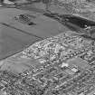
A housing estate (NT47NW 119) has now been constructed on the site of this settlement and that of an adjacent settlement (NT47NW 21).
Information from RCAHMS (SWC) 24 May 2004.
Aerial Photographic Transcription (14 June 1993 - 16 June 1993)
An aerial transcription was produced from oblique aerial photographs. Information from Historic Environment Scotland (BM) 31 March 2017.

