
Costerton


Fort (Period Unassigned), Souterrain (Prehistoric)(Possible)
Site Name Costerton
Classification Fort (Period Unassigned), Souterrain (Prehistoric)(Possible)
Canmore ID 54827
Site Number NT46SW 39
NGR NT 44528 63217
Datum OSGB36 - NGR
Permalink http://canmore.org.uk/site/54827


- Council East Lothian
- Parish Humbie (East Lothian)
- Former Region Lothian
- Former District East Lothian
- Former County East Lothian
NT46SW 39 NT 44528 63217
Note (3 December 2015 - 20 October 2016)
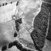
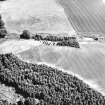
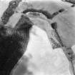
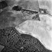
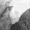
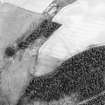
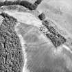
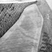
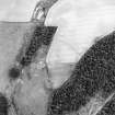
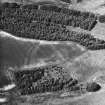
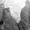
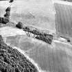
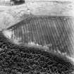
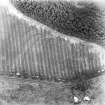
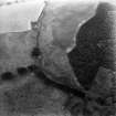
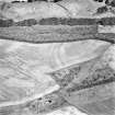
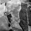
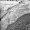
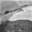
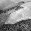
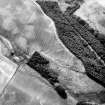
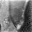
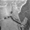
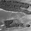
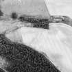
Cropmarks have revealed the site of a complex fort on promontory descending towards a minor confluence on the SE bank of the gully of the Keith Water to the NE of Costerton Mains. No fewer than three ditches bar access to the promontory from the SW, though the way the medial one converges on the inner on the NW, almost certainly forming one side of an entrance way along the NW margin of the promontory, clearly demonstrates that the ditch-system represents at least two phases of construction. The Inner and outer ditches, between 4m and 5m in breadth and set some 17m apart, cut off an area within the modern field measuring at least 135m in length, but with the gently shelving character of the promontory the interior may have extended a further 65m down towards its tip on the NNE. On the SSW, immediately to the rear of the defences, the interior is at least 100m broad, tapering to perhaps 50m where the ground descends outside the modern field; thus the interior extends to at least 0.8ha within the field, and up to 1.2ha including the slope to the NE. In this phase the ditches spring from the lip of the promontory on the NW, possibly indicating that the entrance was along the SE margin where the inner possibly terminates just short of the edge of the field. The precise sequence between these defences and the medial ditch cannot be determined from the photographs, but the latter intersects two probable palisade trenches set concentrically outside the inner ditch, while traces of another two are visible on some of the photographs between the medial and outer ditches. Again any sequence between these and the rest of the defences is unknown, though none of them can be contemporary with the medial ditch. The area enclosed by this ditch is evidently a little larger and its inward turn on the NW suggests a more elaborate entrance, which would have exposed the approaching visitor's right side. Several linear marks are visible within the interior, one of which has been interpreted as a possible souterrain, but the cropmarks also suggest the presence of a shallow depression filled with deeper sediments immediately to the rear of the inner defences at the SW end.
Information from An Atlas of Hillforts of Great Britain and Ireland – 20 October 2016. Atlas of Hillforts SC3784

