
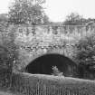
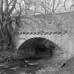
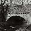
Humbie Mill Bridge


Bridge (17th Century)
Site Name Humbie Mill Bridge
Classification Bridge (17th Century)
Alternative Name(s) Humbie Water
Canmore ID 54788
Site Number NT46SE 3
NGR NT 46118 63005
Datum OSGB36 - NGR
Permalink http://canmore.org.uk/site/54788


- Council East Lothian
- Parish Humbie (East Lothian)
- Former Region Lothian
- Former District East Lothian
- Former County East Lothian
NT46SE 3 46118 63005
(NT 4611 6300) Humbie Mill Bridge (NAT)
OS 6" map (1971)
The bridge over the Humbie Water at Humbie Mill is apparently a 17th c construction. It has one segmental arch with a span of 24'4" and the roadway is 13'10" wide.
RCAHMS 1924
This bridge was rebuilt in 1934 and incorporates a date stone of 1659.
Visited by OS (WDJ) 20 September 1965 and (SFS) 6 August 1975.
Field Visit (9 April 1920)
The bridge (fig. 88) over the Humbie Water at Humbie Mill is apparently a 17th century construction. It is built of uncoursed rubble and has one segmental arch with a span of 24 feet 4 inches. The width of the soffit remains unaltered at 14 ½ feet, and the roadway is 13 feet 10 inches wide. The top of the parapet is 21 feet 2 inches above the water line. The parapets overhang and are borne on unmoulded corbels.
RCAHMS 1924, visited 9 April 1920.

