
Stobshiel


Drain(S) (Period Unassigned), Enclosure (Period Unassigned), Field Boundary(S) (Period Unassigned), Pit(S) (Period Unassigned)
Site Name Stobshiel
Classification Drain(S) (Period Unassigned), Enclosure (Period Unassigned), Field Boundary(S) (Period Unassigned), Pit(S) (Period Unassigned)
Canmore ID 54772
Site Number NT46SE 14
NGR NT 49198 63981
Datum OSGB36 - NGR
Permalink http://canmore.org.uk/site/54772


- Council East Lothian
- Parish Humbie (East Lothian)
- Former Region Lothian
- Former District East Lothian
- Former County East Lothian
NT46SE 14 NT 49198 63981
NT 491 639 A watching brief was undertaken during the removal and replacement of two overhead telegraph poles. These poles were both within a Scheduled Ancient Monument, close to a cropmark enclosure. No archaeological sediments or artefacts were observed.
Sponsor: Scottish Power plc.
R Toolis 2000
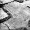
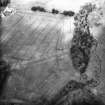
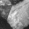
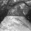
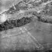
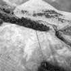
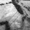
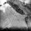
Adjacent to the enclosure there is a field boundary, which is depicted on the 2nd edition of the OS 6-inch map (East Lothian 1894, sheet XIX), and has been recorded as a cropmark on oblique aerial photography (RCAHMSAP 1993), extending from NT 49198 64002 to NT 49177 63832. There are field drains to the SE of the enclosure, and pits to the SW, which have been recorded as cropmarks on an earlier occasion (RCAHMSAP 1977).
Information from RCAHMS (BN) 6 May 2008

