
Ashiestiel Bridge


Road Bridge (19th Century)
Site Name Ashiestiel Bridge
Classification Road Bridge (19th Century)
Alternative Name(s) Ashiesteel Bridge; Low Peel Bridge; River Tweed; Yarrow; Ashestiel Bridge
Canmore ID 54415
Site Number NT43NW 9
NGR NT 43867 35076
Datum OSGB36 - NGR
Permalink http://canmore.org.uk/site/54415


- Council Scottish Borders, The
- Parish Caddonfoot
- Former Region Borders
- Former District Ettrick And Lauderdale
- Former County Selkirkshire
NT43NW 9 43867 35076
(NT 4386 3506) Ashiesteel Bridge (NAT)
OS 6" map (1957)
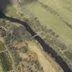
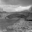
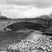
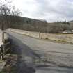
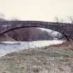
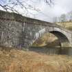
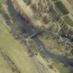
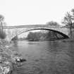
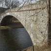
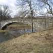
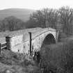
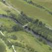
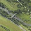
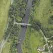
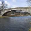
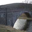
Low Peel Bridge. Ashiesteel Bridge, sometimes called Low Peel Bridge, crossing the River Tweed, was built in 1847. Constructed of whinstone rubble, its span is 132 ft, while it measures 203 ft in length, including the approaches, by 18 ft 10 ins in overall breadth. The structure was repaired in 1952. It is understood that the bridge collapsed once during its original construction, before the arch was completed.
RCAHMS 1957, visited 1953; SDD List
(Location cited as NT 439 351). Yarrow, Ashiestiel Bridge. Built 1847 by J and T Smith, Darnick, engineers. A remarkable single-segmental-arched rubble span. A long flat elliptical rubble arch. Nearby is a good example of a contemporary bridge over a small stream.
J R Hume 1976.
As described: a well-preserved bridge in daily use.
Visited by OS (MJF) 29 November 1979.
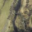
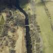
This bridge carries an unclassified public road over the River Tweed, within the parish of Caddonfoot.
Information from RCAHMS (RJCM), 9 July 1998.
Publication Account (2007)
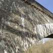
This road bridge crosses the Tweed in a single graceful semi-elliptical arch of 13112 ft with a rise of 26 ft. It is one of the world’s largest rubble masonry spans and the closing bridge achievement of J. & T. Smith of Darnick.
The present structure, dating from 1847–48, represents the second attempt to build this bridge. It was reported
that when the temporary timber centring supporting the arch of the first bridge during its construction was
removed ‘the keystone shot up into the air and the whole bridge collapsed’. The bridge was rebuilt at the Smith
brothers’ expense, but the original contract price of £1200 proved insufficient to meet the cost of both bridges and they ‘failed in business’. The use of a semi-elliptical arch, in addition to maximising the waterway, is perhaps indicative of their understanding that this shape being flatter at Ashestiel Bridge the crown was less likely to fail through the crown being forced upwards. A reinforced concrete slab, spanning over two external
and two internal spandrel walls, was cast in the early 1950s, the bridge remaining open while this work was
done. The parapets and spandrel faces were taken down and rebuilt in the early 1980s.
R Paxton and J Shipway 2007
Reproduced from 'Civil Engineering heritage: Scotland - Lowlands and Borders' with kind permission from Thomas Telford Publishers.
Sbc Note (15 April 2016)
Visibility: Standing structure or monument.
Information from Scottish Borders Council

