|
Prints and Drawings |
RXD 20/1 |
Records of the Royal Commission on the Ancient and Historical Monuments of Scotland (RCAHMS), Edinbu |
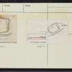
Publication drawing; earthwork, Broadhaugh Hill. |
c. 1948 |
Item Level |
|
|
Prints and Drawings |
RXD 20/2 |
Records of the Royal Commission on the Ancient and Historical Monuments of Scotland (RCAHMS), Edinbu |
Plane-table survey; earthwork, Broadhaugh Hill. |
6/10/1948 |
Item Level |
|
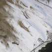 |
On-line Digital Images |
DP 086147 |
RCAHMS Aerial Photography Digital |
Oblique aerial view of the settlement, looking NW. |
2/3/2010 |
Item Level |
|
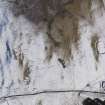 |
On-line Digital Images |
DP 086148 |
RCAHMS Aerial Photography Digital |
Oblique aerial view of the settlement and enclosures, looking W. |
2/3/2010 |
Item Level |
|
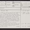 |
On-line Digital Images |
SC 2446638 |
Records of the Ordnance Survey, Southampton, Hampshire, England |
Broadhaugh Hill, NT40NE 10, Ordnance Survey index card, page number 1, Recto |
1958 |
Item Level |
|
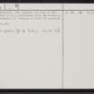 |
On-line Digital Images |
SC 2446639 |
Records of the Ordnance Survey, Southampton, Hampshire, England |
Broadhaugh Hill, NT40NE 10, Ordnance Survey index card, page number 2, Verso |
1958 |
Item Level |
|
 |
On-line Digital Images |
SC 2446640 |
Records of the Ordnance Survey, Southampton, Hampshire, England |
Broadhaugh Hill, NT40NE 10, Ordnance Survey index card, Recto |
1958 |
Item Level |
|
 |
On-line Digital Images |
SC 2446641 |
Records of the Ordnance Survey, Southampton, Hampshire, England |
Broadhaugh Hill, NT40NE 10, Ordnance Survey index card, Recto |
1958 |
Item Level |
|
|
All Other |
551 166/1/1 |
Records of the Ordnance Survey, Southampton, Hampshire, England |
Archaeological site card index ('495' cards) |
1947 |
Sub-Group Level |
|


