
Old Craighall


Pit(S) (Prehistoric), Pit Alignment(S) (Prehistoric)
Site Name Old Craighall
Classification Pit(S) (Prehistoric), Pit Alignment(S) (Prehistoric)
Alternative Name(s) Eastfield
Canmore ID 53831
Site Number NT37SW 178
NGR NT 33820 70533
NGR Description NT centred on 33820 70533
Datum OSGB36 - NGR
Permalink http://canmore.org.uk/site/53831


- Council East Lothian
- Parish Inveresk (East Lothian)
- Former Region Lothian
- Former District East Lothian
- Former County Midlothian
NT37SW 178 centred on 3382 7053
Aerial Photographic Transcription (1 April 2004 - 3 April 2004)
An aerial transcription was produced from oblique aerial photographs. Information from Historic Environment Scotland (BM) 31 March 2017.
Aerial Photographic Interpretation (19 March 2014)
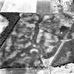
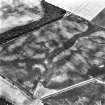
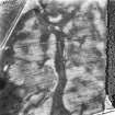
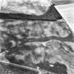
Several pit alignments and a cluster of pits have been recorded as cropmarks on oblique aerial photographs (RCAHMSAP 1981) to the S of a former river channel. The longest pit alignment is made up of a series of elongated pits and extends from NE to SW (NT 33954 70669 to NT 33760 70496) for a distance of about 265m. A cluster of pits, formerly recorded as a pit circle, adjoins the pit alignment at its S end. Three short sections of further pit alignments have been recorded to the E.
Information from RCAHMS (KMM) 19 March 2014

