
Newbyres Castle


Tower House (Medieval)
Site Name Newbyres Castle
Classification Tower House (Medieval)
Canmore ID 53640
Site Number NT36SW 7
NGR NT 34430 61454
Datum OSGB36 - NGR
Permalink http://canmore.org.uk/site/53640


- Council Midlothian
- Parish Borthwick
- Former Region Lothian
- Former District Midlothian
- Former County Midlothian
NT36SW 7 3443 6145.
(NT 3443 6145) Newbyres Castle (NR) (rems of)
OS 6" map (1967)
The Object Name Book of the Ordnance Survey describes 'Newbyres Castle (in ruins)' as ' A very old building of a rectangular form on the West side of Gorebridge. There is no person in the neighbourhood that can give any information respecting when, or by whom it was erected'
Name Book 1852
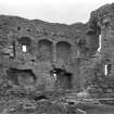
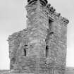
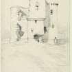
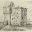
Newbyres Castle, a mid-16th century tower, is in an unsound, ruinous condition. On plan, it has been an L-shaped building, a main block 32 1/2' NNE-SSW by 24', with the wing, at the S angle, measuring 15 1/4' by 5'. Only the foundations of the latter remain. The walls of the main block facing N and W are complete to the wall-head, but the others are fragmentary.
Vague foundations of outbuildings may be traced under the turf to N and S of the tower. The site occupied by the tower is roughly triangular, naturally defended by deeply worn water-courses; there appears to have been a courtyard wall.
RCAHMS 1929, visited 1915
The NE corner of the tower, standing 4.0m high, and an adjacent mound of overgrown rubble are all that remain of Newbyres Castle.
Visited by OS (BS) 28 October 1975.
NMRS NOTES:
To be demolished, July 1963
EXTERNAL REFERENCE:
National Library:
Building News 22nd August 1879 - plans and restored views by W F Lyon
Project (19 May 2018 - 20 May 2018)
NT 34430 61454 A geophysical survey was carried out, 19 – 20 May 2018, at the castle as part of a wider archaeological programme being undertaken by Gorebridge Community Development Trust as part of Archaeology Scotland’s Adopt a Monument scheme.
A c0.2ha area was investigated using resistance and ground penetrating radar (GPR). The survey was part of a community event with members of the Trust assisting with the data collection as part of an open day.
High levels of background response have been recorded over the higher terrace in the N of the survey area with several discrete, rectilinear anomalies detected to the N of the castle. The GPR survey has also identified several discrete responses to the N of the castle which show good correlation with the resistance survey results. The orientation of these responses with respect to the castle suggests they may be associated with the castle. However, whether they are due to potential structures contemporary with the castle, such as outbuildings and / or the limit of an outer courtyard, is unclear. As there is some suggestion that the terrace is a relatively modern construction associated with the demolition of the Castle in the 1960s, they could simply be associated with the demolition.
Within the lower terrace to the S and W of the castle several weak trends have been noted. However, interpretation of these is cautious given modern activity such as planting and emplacement of footpaths.
Archive: Rose Geophysical Consultants
Funder: Archaeology Scotland on behalf of Gorebridge Community
Susan Ovenden – Rose Geophysical Consultants
(Source: DES Volume 19)
Resistivity (19 May 2018 - 20 May 2018)
NT 34430 61454 Resistivity was carried out, 19 – 20 May 2018, at the castle as part of a wider archaeological programme being undertaken by Gorebridge Community Development Trust as part of Archaeology Scotland’s Adopt a Monument scheme.
Archive: Rose Geophysical Consultants
Funder: Archaeology Scotland on behalf of Gorebridge Community
Susan Ovenden – Rose Geophysical Consultants
(Source: DES Volume 19)
Ground Penetrating Radar (19 May 2018 - 20 May 2018)
NT 34430 61454 Ground penetrating radar was carried out, 19 – 20 May 2018, at the castle as part of a wider archaeological programme being undertaken by Gorebridge Community Development Trust as part of Archaeology Scotland’s Adopt a Monument scheme.
Archive: Rose Geophysical Consultants
Funder: Archaeology Scotland on behalf of Gorebridge Community
Susan Ovenden – Rose Geophysical Consultants
(Source: DES Volume 19)

