
Langside


Gravel Pit (19th Century)-(20th Century), Pit Alignment (Prehistoric)
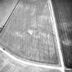
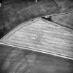
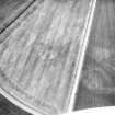
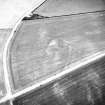
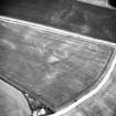
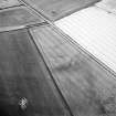
Site Name Langside
Classification Gravel Pit (19th Century)-(20th Century), Pit Alignment (Prehistoric)
Alternative Name(s) Dalkeith Northern Bypass
Canmore ID 53396
Site Number NT36NE 67
NGR NT 36041 68199
Datum OSGB36 - NGR
Permalink http://canmore.org.uk/site/53396


- Council Midlothian
- Parish Dalkeith
- Former Region Lothian
- Former District Midlothian
- Former County Midlothian
NT36NE 67 NT 36041 68199
NT 335 695-NT 378 667 An archaeological evaluation was undertaken between September and November 1994 of the proposed route of the A68 Dalkeith Northern Bypass, from its proposed junction with the Edinburgh City Bypass to its proposed junction with the existing A68 at Fordel Mains. The evaluation comprised a desk-based assessment, field inspection, selective fieldwalking, and trial trenching. A total area of 9872 sq m, divided between 154 trenches in 23 land parcels, was sampled by trial trenching along the road corridor. Seperate entries have been compiled for the excavations at Castle Steads pit alignment (NT36NW 53), Smeaton Temporary Camp (NT36NW 33) and Smeaton Brick and Tile Works (NT36NW 109), which were previously known sites and thus not subject to preliminary evaluation.
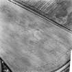
Several known sites lay adjacent to the evaluation corridor; and neighbouring areas were thus examined.The desk-based assessment discounted the site of the Langside cropmark enclosure (NMRS NT36NE 67) being of archaeological significance; its location corresponds with the site of a disused gravel pit recorded on the OS first and second edition maps. The evaluation did not locate any archaeological evidence for a known pit alignment (NMRS NT36NW 52) where its extrapolated line intersected the road corridor immediately beside the Edinburgh City Bypass (NT 335 696). Excavation showed that the area had been severely affected during the construction of the Edinburgh City Bypass, and the pit alignment has most likely been destroyed here. The evaluation did not find any direct evidence of the cist cemetery (NMRS NT36NW 5) known to lie adjacent to a proposed slip road (NT 348 688). However, the sand extraction pit mentioned in the NMRS record, and in which the cists were located, was found, as was a pipe trench opened in the 1970s, in which two cists were also previously located. Trenches excavated adjacent to the site of Smeaton Brick and Tile Works in the same field (NT 349 689) revealed deposits of associated industrial waste material. An area of possible environmental interest was located around the Bellyford Burn, comprising a peat deposit containing pieces of 'bog oak' (NT 368 676 area).
In addition, the evaluation produced evidence of isolated features of lesser significance, such as areas of rig-and-furrow, small (modern) pits, field drains, a probable ploughed out field dyke and a length of ditch of unknown date.
A Data Structure Report has been produced, and will be deposited in the NMRS.
Sponsor: Roads Directorate of The Scottish Office Industry Department, managed on its behalf by Historic Scotland.
R J Strachan and A R Rees 1995.
The gravel pit is not shown on the 1st edition of the OS 6-inch map (Edinburghshire 1854, sheet 7) but is depicted on the 2nd edition of the OS 25-inch map (Edinburghshire 1907, sheet VIII.8) and annotated as 'Old Gravel Pit'.
Information from RCAHMS (KC) 1 September 1995.
Site identified during an archaeological assessment carried out by CFA Archaeology Ltd.
Mhairi Hastie, 2006.

