
Oxenfoord Mains


Enclosed Settlement (Later Prehistoric)
Site Name Oxenfoord Mains
Classification Enclosed Settlement (Later Prehistoric)
Canmore ID 53372
Site Number NT36NE 49
NGR NT 39767 67521
Datum OSGB36 - NGR
Permalink http://canmore.org.uk/site/53372


- Council Midlothian
- Parish Cranston
- Former Region Lothian
- Former District Midlothian
- Former County Midlothian
Note (1988)
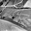
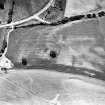
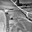
Oxenfoord Mains NT 3975 6748 NT36NE 49
Cropmarks reveal an enclosure 400m NE of Oxenfoord Mains. Although the E side is not clearly defined, the enclosure measures at least 60m square within a ditch up to 3m broad, and there is an entrance on the NW.
RCAHMS 1988

