
Edinburgh, Craigmillar Castle Road, Craigmillar Castle


Castle (Medieval)
Site Name Edinburgh, Craigmillar Castle Road, Craigmillar Castle
Classification Castle (Medieval)
Canmore ID 52109
Site Number NT27SE 107
NGR NT 28807 70875
Datum OSGB36 - NGR
Permalink http://canmore.org.uk/site/52109


First 100 images shown. See the Collections panel (below) for a link to all digital images.
- Council Edinburgh, City Of
- Parish Edinburgh (Edinburgh, City Of)
- Former Region Lothian
- Former District City Of Edinburgh
- Former County Midlothian
NT27SE 107.00 28807 70875
NT27SE 107.01 288 702 garden
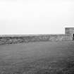
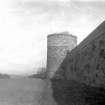
NT27SE 107.02 28849 70915 Dovecot
(NT 2882 7088) Craigmillar Castle (NR) (remains of)
Chapel (NR) Dovecot (NR)
OS 6"map, (1966).
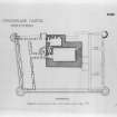
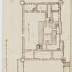
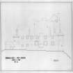
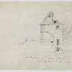
Craigmillar Castle is fully described, planned and illustrated in the official guidebook and in RCAHMS 1929.
RCAHMS 1929, visited 10 May 1920; W D Simpson 1954.
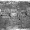
Trial trenching was carried out in advance of the construction of a new car park for Craigmillar Castle. Nine trenches were excavated, eight of which were archaeologically sterile. A small sandstone quarry was located, backfilled apparently in the 19th century.
Sponsors: City of Edinburgh Council, Millennium Forest for Scotland.
M A Collard 1996.
(NT 2881 7087) A watching brief was undertaken during the excavation of an electricity trench outside Craigmillar Castle. The castle sits on the crest of a ridge, with the ground beginning to fall away some 40m to the E. Bedrock, a red sandstone, appeared through the turf in places.
The short N-S stretch (3.8m long), dug by hand next to the NE tower of the castle, revealed below topsoil a light grey fine silt with much sandstone, mortar, charcoal, china, bottle glass, etc, throughout. This was present for the full c.250mm depth that this stretch was excavated to. The castle wall itself has footings that projected some 150mm out from the wall face, but here bedrock was only c 100mm below the modern ground surface, and the wall lay directly on this.
At the N end of this trench, where it turned E, it was excavated by machine. The westernmost c.14m stretch produced the same silty deposit below topsoil for a depth of 400mm, with the trench bottoming on different material. At one c.9m stretch, a bed of loose pale yellow sandstone rubble may represent a foundation raft for the tower.
The fine grey silt overlying the area is seen as probably representing 19th or 20th-century deposits, probably introduced deliberately as levelling material; the large stones present make an agricultural or garden soil unlikely. The sandstone deposit near the 16th-century NE tower of the castle may relate to this tower, but was not physically related to it in this trench.
A further watching brief was maintained in February 1998 during the excavation of a cable trench in the outer courtyard. All trenching took place over previously disturbed ground.
Sponsor: Historic Scotland
D Stewart 1998
(NT 288 708) A series of nine test trenches was dug in November 2002 in the field to the N of the castle to investigate soil porosity ahead of new drainage for car parking. Nothing of archaeological significance was found.
Archive to be deposited in the NMRS.
Sponsor: HS
G Ewart 2003
NT27SE 107.00 28807 70875
NMRS Print Room
W Schomberg Scott Photograph Collection, Acc no 1997/39
3 Views from South East
NMRS Print Room
Inglis Photograph Collection, Acc no 1994/90
'35. Craigmillar Castle. near Edinr. J.P.' - exterior view
Information from Architecture Catalogue slip:
REFERENCE: SRO
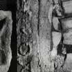
Mason work at Craigmillar Castle.
Measurement of mason work done by John Bain for Col. Gilmour. It includes windows, doors and lintels of the Castle and the door on the Castle Court.
Liberton Papers - Household Accounts, 1702 - 1823 (page 82)
1820
GD 122/iv/no.143
Alterations to the windows of Craigmillar [?].
Wright's account for ?24.8.0 from William Rankin to Sir Alexander Gilmour.
Craigmillar Correspondence: Discharges, 1725 - 1729 (page 43)
1729
GD 122/iv/no.127
REFERENCE
NATIONAL LIBRARY
"MS 3245" Sketches by Edward Duncan - 1 sketch dated 1869
Uncatalogued MSS of General Hunton, Vol.1 No.71 - 1 sketch dated 1781
Field Visit (10 May 1920)
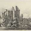
Craigmillar Castle.
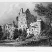
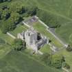
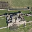
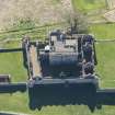
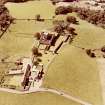
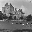
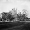
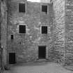
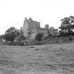
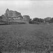
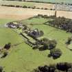
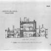
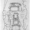
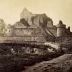
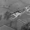
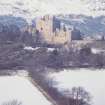
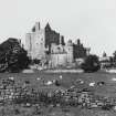
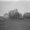
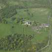
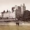
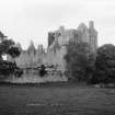
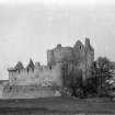
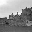
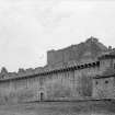
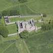
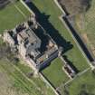
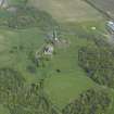
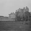
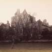
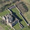
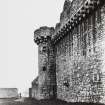
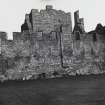
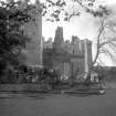
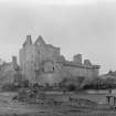
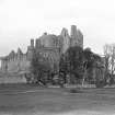
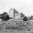
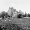
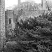
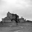
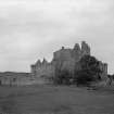
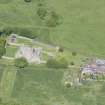
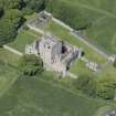
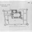
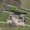
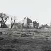
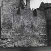
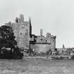
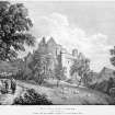
The castle of Craigmillar, stands on a rocky eminence three miles south of Edinburgh. Its most prominent feature is a massive tower, L-shaped on plan, built on the verge of a terrace, from which the rock drops sheer for 30 feet. The tower, however, was enclosed with a quadrangular curtain-wall embodying the south wall of the wing, and against this curtain lower buildings were erected, except at the southwest where the space was restricted by the tower. Only the lower parts of the structures on the south-east and south-west are contemporary with the original wall, while the building against the north face has disappeared. On north, east, and west is an outer wall, within which are separate buildings.
The buildings and enclosure walls are constructed in the fine light-coloured freestone which abounds on the site. The stone throughout has weathered well, and with time has mellowed to a harmonious shade of grey. The approach is from the north, but returns westward along the brow of the hill beneath the outer wall to the main entrance gateway, 7 ¾ feet wide, with a semicircular head; beside the entrance, but outside the enclosure, there can be traced a range of building, probably stabling. The outer enclosure is a 16th-century construction nand contains the following buildings. A circled tower at the north-east angle is a dovecot; its lower stage is furnished with gun-loops aligned on the main entrance, and on a second gate in the east wall. On the east is the chapel, which is a late pre-Reformation structure, on the west a garden with a long range of building on its north, against which building there has been a lean-to on the north side; at the north-west is the "presbytery," a Protestant Presbyterian meeting-house erected after 1687, upon the Indulgence granted by James VII (1).
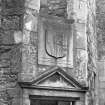
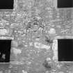
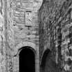
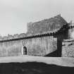
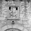
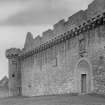
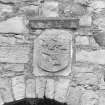
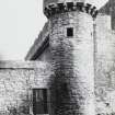
The curtain returns on the south, incorporating the south wall of the tower wing, along the crest of the upstanding rock for a distance of 128 ½ feet, then turns northward and completes the enclosure. At the angles are salient circled towers with loops enfilading the exterior surface of the walls. The curtain entrance is on the north. It is a wide gateway with a semicircular head, and has been contracted. Above it, within a moulded border, is a panel, probably dating from the 16th century, which bears, according to Nisbet (2), " a shield couche, three unicorns' heads couped . . . supported by two lions; and for crest, a unicorn's head issuing out of a coronet instead of a wreath; motto, PRIESTO UT PRIESTEM. Below, on the stone, is the year of God 1427." The achievement is greatly weather-worn, but the armorial bearing can be deciphered, and is correctly stated by Nisbet. There is no trace of the motto and date, but on the outer surface of the upper border there appear to be a coronet, a wreath, and a saltire flanked by two roundels, one of which might be foiled. On the lower border there has been an inscription in capitals, which reads CRAGM[Y]LLOR. It should be noted, however, that the curtain is a 15th-century construction, for which 1427 is a possible date. Above, on the parapet, is a second and smaller panel bearing beneath a coronet a shield charged with a lion rampant within a double tressure flory-counter-flory, the Royal Arms of Scotland. From the curtain gate a passage round three sides of the tower leads to the entrance, which is situated in the west wall of the wing.
HISTORICAL NOTE. In 1544, on the occasion of Hertford's invasion, the property of Edinburgh people was taken to the castle for safe custody. The place was surrendered to Hertford on condition that no damage should be done, but it was "brunt and destroyit"(4), which necessitated reconstruction. On the Prestons and their successors in Craigmillar, see Introd., pp. xxxvii-viii.
[for a detailed architectural description see RCAHMS 1929 pp.120-6]
RCAHMS 1929, visited 10 May 1920.
(1) Archaeologia Scotica, i, p. 328 ; (2) Nisbet's Heraldry, i, p. 305 ; (3) See Introd. , p. xxxvii; (4) Diurnal of Occurrents, p. 32.
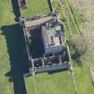
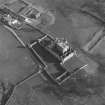
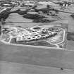
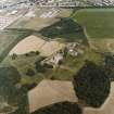
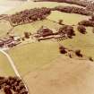
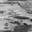
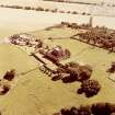
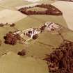
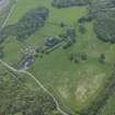
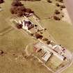
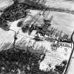
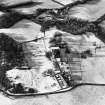
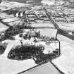
Aerial Photography (1971)
Oblique aerial photographs of Craigmillar Castle, Edinburgh, by Mr John Dewar in 1971.
Publication Account (1985)
By the 17th century, Craigmillar Castle had more or less achieved its final form. In 1661 the west wings were reconstructed for Sir John Gilmour who had just bought the barony from the Prestons-its owners since 1374 and recalled not only in armorial tablets but also in the P-shaped hollows of a pond outwith the southern walls, a pond once stocked to provide fresh fish for those within.
The east side of the courtyard, by contrast, had been rebuilt following the burning of the castle in 1544 by English forces under Hertford- they "gatt great spoylen since Edinburgh folk had "sowght to saifthare movables thairin". The outermost curtain, or rather precinct, wall was built then too, furnished with gunloops but not with battlements. A doocot was incorporated in its north-east corner.
These reconstructions and extensions did not conflict with earlier principles of fortification, however. The castle had continued to develop on medieval pattern; and the massive L-shaped tower-house continued to play a central role.
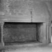
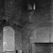
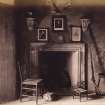
Built above a rocky 9m precipice, the original 14th century entrance faced west, protected by a shelving pitfall (now filled in) spanned in peace-time by a timber bridge. Stout doors, an iron yett, narrow passages and spiral turnpike stair added to an attackers problems. Above, the Great Hall occupied the entire first floor of the main block, fitted with a fine stone, probably 15th century fireplace, hooded and elaborately moulded. The original kitchen, at the same level, is known as Queen Mary's Room, her place of retreat in 1566 after the murder of Rizzio in Holyroodhouse; and here at Craigmillar the plot was hatched to murder her ailing husband Darnley.
In 1427, the massive enceinte was built around the tower, enclosing the present inner courtyard. Its walls are remarkably complete, with towers at each corner and parapet walks to the north, east, and part of the south. And whilst the tower-house carries a parapet rising flush from the wall, that of the curtain-wall projects-with openings in the floor through which unpleasant gifts could be dropped on to the attackers. This kind of parapet, though known earlier south of the Tweed, spread northwards only after about 1400. Furthermore, the north-east tower has openings for cannon to defend the main approach to the castleamongst the first such batteries in Scotland.
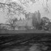
Craigmillar is probably the best example of a medieval castle surviving in Scotland, built according to 15th and 16th century principles of fortification, and it affords spectacular views of Edinburgh's Old Town skyline.
Information from 'Exploring Scotland's Heritage: Lothian and Borders', (1985).
Watching Brief (5 August 1996 - 6 August 1996)
Three trial pits were excavated by hand within the walled area immediately north of the northern limits of the castle. The three trenches were located in order to characterise the archaeological potential of the area in general, as well as to investigate the state and extent of the present waste-disposal system.
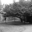
The terrace with its sycamores is a modern feature, dating to some time after 1954. Evidence of pre-terrace landscape elements were visible in this area. The evidence for metalling in Trench 1 suggests that the bedrock was exposed, and that attempts were made to fill cracks and vagaries in the rock to provide a useful surface, although the date for this is at present uncertain. An old ground surface was encountered in Trench 3 towards the eastern end of the area of investigation, and bedrock was arguably over 0.5m deeper than this. An impression was therefore gained of an area of exposed bedrock and levelling extending as far eastwards as the blocked door noted in the north enclosure wall of the castle, before dropping again to a terrace which has at some stage seen cultivation. No finds were retained.
Sponsor: Historic Scotland
G Ewart and A Dunn 1996
Kirkdale Archaeology
Excavation (4 October 1996 - 16 December 1996)
Kirkdale Archaeology was contracted to monitor the clearance work in advance of the construction of a new toilet block and staff accommodation in the west range of the castle, the site of the 1687 Presbyterian Kirk as well as a large trench for the new septic tank on the north side of the north castle enclosure wall, and the excavation of associated drainage tracks to the east of this. This area had previously been investigated by trial trenching in August.
The wall in Trench 4 ran parallel to the present east wall of the west range, and may relate to some internal division within the Presbyterian Kirk. No finds were made, and so the exact date of the structure cannot be ascertained. The possible feature recorded in Trench 5 may also relate to the use of the area as a Presbyterian Kirk, although as with Trench 4 no finds were recovered which could aid in the interpretation of the feature.
The wall revealed at the east end of Trench 7 may relate to the 16th-century stables mentioned in the entry for Craigmillar Castle in the RCAHMS volume, which records such a structure as having stood against the north face of the north enclosure wall. No finds were made to either support or undermine this interpretation.
Sponsor: Historic Scotland
Kirkdale Archaeology
G Ewart and A Dunn 1996
Watching Brief (28 November 1997)
Kirkdale Archaeology were asked to oversee the excavation of an electricity trench outside Craigmillar castle. The trench was to be c. 75 m long, and was to run from the tower in the NE of the curtain wall Eastwards, along the S side of the existing road, towards the castle's ticket office.
The trench was machine excavated, except for two short stretches - one beside the castle, and the other next to the ticket office where an existing electricity cable lay. Before excavation it was apparent that the castle sits on the crest of a ridge, with the ground beginning to fall away some 40 m to the E of the castle. Bedrock, a red sandstone, appeared through the turf in places.
The fine grey silt overlying the area is seen as probably representing nineteenth or twentieth century deposits, probably introduced deliberately as levelling material - the large stones present make an agricultural or garden soil unlikely. The stone and concrete structure could not be interpreted with any confidence. The sandstone deposit noted some 40 cm down near the sixteenth century N.E tower of the castle may relate to this tower, but was not physically related to it in this trench. The overall shallowness of soil cover was notable.
Sponsor: Historic Scotland
G Ewart 1997
Kirkdale Archaeology
Watching Brief (11 February 1998 - 12 February 1998)
A watching brief was maintained over two days from 11th – 12th February 1998 during the excavation of a cable trench in the Outer Courtyard at Craigmillar Castle. The trench was to be 102 m in length and 400 mm in width, following the line of an existing power cable. All trenching took place therefore over previously disturbed ground.
The trench proceeded from the South entrance to the old Presbyterian Church, where the earlier cable trench had cut the base of the church wall. Thereafter the trench followed the inside face of the courtyard wall for c. 24 m, beofre cutting across the main entrance and turning into the courtyard itself.
Sponsor: Historic Scotland
D Stewart 1998
Kirkdale Archaeology
Excavation (26 November 2002 - 27 November 2002)
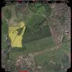
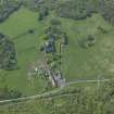
Under the terms of its P.I.C. call-out contract with Historic Scotland, Kirkdale Archaeology was asked to undertake archaeological monitoring while a series of machine dug trenches was cut for soil porosity testing, in advance of new drainage for car parking. The area was downhill from the castle approach road, within the open field to the N of the Castle. The castle sits at the summit of a long steady gradient running down towards the Craigmillar housing estate, and featured as a prominent landmark in an 18th and 19th-century designed landscape.
The results of this programme of test trenching suggest there is no obvious archaeological activity towards the E of the large open field. The castle appears to have been approached from the N and on the evidence of these trenches the general area was neither cultivated nor occupied. However, it is possible that the present archaeological sterility is due to a post-medieval programme of clearance and landscaping, in a general attempt to highlight the castle within a more informal park or ‘borrowed landscape’ context.
G Ewart 2002
Sponsor: Historic Scotland
Kirkdale Archaeology
Watching Brief (20 March 2007)
Prior to the proposed removal of existing gravel surfacing, small trial trenches were dug at Craigmillar Castle to assess the nature of deposits under the gravel in the inner courtyard and in the drawing room. There appeared to be make up deposits below the current level of the courtyard, perhaps suggesting an earlier, lower level.
David Murray, (Kirkdale Archaeology) 2007. OASIS ID: kirkdale1-60038
Excavation (1 November 2007 - 16 November 2007)
NT 283 705 Prior to resurfacing shallow excavations were carried out 2–16 November 2007. The existing gravel and the deposits below it were removed to a depth of c150mm over much of the courtyard.
The fine-grained sandstone bedrock was exposed in a few areas. This sandstone is an excellent building material and was probably used for much of the construction at this site. Outside the courtyard an E/W ridge of bedrock was used as the site for the original tower.
Along the limit of the castle, on the S side in particular, is a low cliff line whose edge is followed by masonry. The drop is less dramatic on the N side of the site, but the fact that bedrock was exposed along the base of the tower demonstrates that it sits on the summit of a low ridge.
The excavations uncovered the upper deposits of an interesting and complex site that has seen little modern disturbance. Although the shallow nature of the excavations made it difficult to interpret fully the many features exposed, the work demonstrated the significant archaeological potential of the site.
David Murray 2008
Sponsor: Historic Scotland
Kirkdale Archaeology
Excavation (16 February 2009)
NT 2882 7088 A watching brief and minor excavation were carried out 16 February 2009 on the East Range during the excavation of three test trenches. The work allowed the examination of previously undisturbed deposits and ascertained the floor make-up and the height of the vaults, prior to remedial works to prevent water inundation.
Archive: RCAHMS (intended)
Funder: Historic Scotland
Kirkdale Archaeology 2009
Excavation (22 November 2010 - 15 December 2010)
During November and December 2010 a watching brief and minor excavation were carried out on the East Range during the excavation of three test trenches to ascertain the floor make-up and establish the height of the vaults prior to remedial works to prevent water inundation. The opportunity was taken to examine previously undisturbed features and deposits.
Headland Archaeology December 2010. OASIS-ID kirkdale1-172052
Watching Brief (6 September 2013)
Under the terms of its PIC call-off contract with Historic Scotland, Kirkdale Archaeology was asked to examine exposed surfaces and deposits below an uprooted tree located on the S side of the main approach road to Craigmillar Castle, in the area E of the E Garden.
The evidence suggests that the area immediately E of the E postern gateway (currently blocked), located close to the Chapel, had been levelled to create a platform or terrace, the N edge of which may have respected the S edge of the approach route to the E gate. There was no dateable evidence for the construction of the terrace, but it may relate to the creation of the outer garden suite during the mid 16th century. An association with the cherry and sycamore planting of c.1900 is also possible, although parts of the site are clearly too shallow for mature trees.
G Ewart 2013
Sponsor: Historic Scotland
Kirkdale Archaeology
Project (1 February 2018 - 23 April 2018)
NT 28807 70875 A programme of geophysical survey was undertaken, 1 – 13 February 2018 (Phase 1) and 1 March – 23 April 2018 (Phase 2) within and around Craigmillar Castle. The survey covers the PIC area of 2.6ha and c13.5ha within Craigmillar Castle Park to the N, W and S of the castle.
The gradiometer survey within the main castle area has not identified any significant anomalies, but an area of increased noise to the E of the castle, outwith the courtyard walls, may be of interest. This coincides with discrete resistance anomalies which could potentially be of archaeological interest, but this interpretation is cautious as the anomalies could simply be due to root bowls associated with the former orchard. Within the castle complex resistance and GPR surveys have identified anomalies suggesting possible former layouts / paths within the W and E gardens. Resistance anomalies suggesting possible elements of structural remains have been detected in the W of the outer courtyard, but interpretation is tentative given the responses from the shallow bedrock.
Few anomalies have been detected within the P-Pond field to the S of the castle. Both the gradiometer and the resistance data are dominated by responses from buried services, a former track and presumed rig and furrow cultivation. Additional linear anomalies suggesting possible drainage features have also been noted in the gradiometer data. The resistance data is dominated by responses from shallow bedrock, although some anomalies may indicate man made features.
Within Craigmillar Castle Park, to the N of the castle, the data appears to be showing an earlier network of paths and tracks. A very weak, broad curving anomaly has been detected in the N of the park, but resistance survey suggests it is probably natural in origin. Elsewhere within the park the gradiometer data is dominated by high levels of magnetic noise and agricultural trends.
Archive: Rose Geophysical Consultants
Funder: CFA Archaeology on behalf of HES
Susan Ovenden – Rose Geophysical Consultants
(Source: DES Vol 19)
Magnetometry (1 February 2018 - 23 April 2018)
NT 28807 70875 A magnetometry survey was undertaken, 1 – 13 February 2018 (Phase 1) and 1 March – 23 April 2018 (Phase 2) within and around Craigmillar Castle. The survey covers the PIC area of 2.6ha and c13.5ha within Craigmillar Castle Park to the N, W and S of the castle.
Archive: Rose Geophysical Consultants
Funder: CFA Archaeology on behalf of HES
Susan Ovenden – Rose Geophysical Consultants
(Source: DES Vol 19)
Resistivity (1 February 2018 - 23 April 2018)
NT 28807 70875 A resistivity survey was undertaken, 1 – 13 February 2018 (Phase 1) and 1 March – 23 April 2018 (Phase 2) within and around Craigmillar Castle. The survey covers the PIC area of 2.6ha and c13.5ha within Craigmillar Castle Park to the N, W and S of the castle.
Archive: Rose Geophysical Consultants
Funder: CFA Archaeology on behalf of HES
Susan Ovenden – Rose Geophysical Consultants
(Source: DES Vol 19)
Dendrochronology (August 2021)
NT 28742 70783 A programme of dendrochronological work was undertaken, in August 2021, at Craigmillar Castle.
Historic Environment Scotland (HES) requested the dendrochronological assessment of a timber lintel recently removed from above a doorway of the Gilmour Range at Craigmillar Castle for safety reasons. The rationale was to check for dating potential in relation to the evolution of Craigmillar Castle, including a possibility of earlier timber elements being re-used as lintels, as well as being a possible opportunity to gather valuable tree-ring data more generally. It was thought possible this lintel would be re-used oak from the medieval castle, but it has proved not to be the case. In this case, an unusual hardwood species has been used to make the lintel from the timber of a young tree around 40 years of age when felled. The tapered shape of the lintel suggests it could have been inserted into the stonework after the original construction of the Gilmour Range and so it may be from a later phase than 1661. Keying on the underside indicates it was originally plastered. The assessment established that it would not be possible to obtain a dendro-date for this lintel because it has too few rings and is made from a species for which there is almost certainly no tree-ring reference data.
Archive: NRHE (intended)
Funder: Historic Environment Scotland
Coralie Mills – Dendrochronicle for CFA Archaeology Ltd
(Source: DES Vol 22)
Standing Building Recording (June 2022)
NT 28794 70915 A programme of archaeological recording of a previously unknown packed stone surface took place at Craigmillar Castle in June 2022. The surface was exposed when a concrete plinth was removed during works to replace interpretation signage near the entrance gate on the N side of the castle. It was not possible to determine the function or date of the stone surface and it was left in situ.
Archive: NRHE and Edinburgh City Council HER (intended) Funder: Historic Environment Scotland
Sang Tran – CFA Archaeology Ltd
(Source: DES Volume 23)

