
Lochore Castle


Castle (Medieval)
Site Name Lochore Castle
Classification Castle (Medieval)
Alternative Name(s) Inchgall Castle; Loch Ore; Inchgall Loch
Canmore ID 51027
Site Number NT19NE 1
NGR NT 17532 95883
Datum OSGB36 - NGR
Permalink http://canmore.org.uk/site/51027


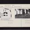
![Engraving of Lochore Castle from the west.
Titled 'Lochore Castle. This Castle is built on a peninsula, on the south side of the loch of Lochore, in the shire of Kinrose, and was erected by Duncan de Lochor, in the reign of Malcolm IV anno 1160: it consisted of a strong square tower, with many lower buildings, surrounded with a wall, having round towers at the corners; the wall on three sides are washed by the water of the loch or lake, which formerly abounded with pike and perch. In the reign of Alexander II. Adam de Lochor was Sheriff of Perth; David de Lochor is in 1255 also Sheriff; in 1289 Hugo de Lochor is Vicompt de Fife, as is Constantinus in 1292; David de Lochor is named in Ragman's Roll in 1296. In 1315 Thomas de Lochor was in the Parliament at Air that tailzed the Crown, and his seal is appended to that act. In the reign of King Robert Bruce the estate came by marriage to Adam de Valloniis, and from them again by marriage to Sir Andrew Wardlaw. Over the door in the tower is inscribed "Robertus de Wardlaw" who greatly fortified and repaired it. This view is from the west.' [Adam de Cardonnell, "Picturesque Antiquities of Scotland," 1788.]](http://i.rcahms.gov.uk/canmore/l/DP00096974.jpg)


![Engraving of Lochore Castle from the west.
Titled 'Lochore Castle. This Castle is built on a peninsula, on the south side of the loch of Lochore, in the shire of Kinrose, and was erected by Duncan de Lochor, in the reign of Malcolm IV anno 1160: it consisted of a strong square tower, with many lower buildings, surrounded with a wall, having round towers at the corners; the wall on three sides are washed by the water of the loch or lake, which formerly abounded with pike and perch. In the reign of Alexander II. Adam de Lochor was Sheriff of Perth; David de Lochor is in 1255 also Sheriff; in 1289 Hugo de Lochor is Vicompt de Fife, as is Constantinus in 1292; David de Lochor is named in Ragman's Roll in 1296. In 1315 Thomas de Lochor was in the Parliament at Air that tailzed the Crown, and his seal is appended to that act. In the reign of King Robert Bruce the estate came by marriage to Adam de Valloniis, and from them again by marriage to Sir Andrew Wardlaw. Over the door in the tower is inscribed "Robertus de Wardlaw" who greatly fortified and repaired it. This view is from the west.' [Adam de Cardonnell, "Picturesque Antiquities of Scotland," 1788.]](http://i.rcahms.gov.uk/canmore/s/DP00096974.jpg)


First 100 images shown. See the Collections panel (below) for a link to all digital images.
- Council Fife
- Parish Ballingry
- Former Region Fife
- Former District Dunfermline
- Former County Fife
NT19NE 1 17532 95883
(NT 1753 9588) Lochore Castle (NR) (In Ruins)
OS 6" map, (1920).
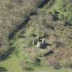
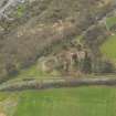
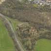
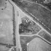
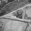
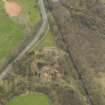
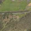
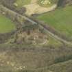
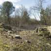
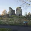
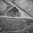
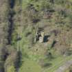
Lochore Castle is situated on a mound at the east end of what was formerly a sheet of water, Loch Ore or 'Inchgall Loch' drained at the end of the 18th century.
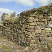
Present appearances suggest that the original castle had been of the motte-and-bailey type and that the motte-hill was reduced in height before the present tower of stone was built. The base of the mound has been enclosed by a barmkin of coursed rubble, now fragmentary and nowhere more than 10ft in height but still traceable all round. At the north-eastern, north western and south-eastern angles there have been small rounded towers, which seem to have been added in the 16th century and are now almost demolished. The entrance to the barmkin enclosure was on the/ the north-west through an arched doorway. The tower probably dates from the 14th century. To the north and west of the tower lie the foundations of later outbuildings.
RCAHMS 1933.
Lochore Castle was apparently approached from the east along a causeway which is reported to have been in existence some years ago.
D MacGibbon and T Ross 1899.
Sir Duncan de lochore in the time of Malcolm IV (1153-65) was the builder of a baronial castle at Lochore.
It is quite certain that the present ruin was no part of it.
A H Millar 1895.
Lochore Castle is in ruinous condition: the description in RCAHMS 1933 is correct. The tower and barmkin are situated on a mound possibly the remains of a motte. The raised enclosure W of the tower, suggested as a possible bailey by RCAHMS would appear to be comparatively recent: small quarries reveal that it is apparently composed of ash, cinder, etc.
Visited by OS (AC) 13 March 1959.
'Adam de Vallance who was descended from an Anglo-Norman family married the elder daughter and heiress of Sir David Lochore, some time prior to 1296 and may have lived for a short time in Lochore Castle which by then was becoming obsolete (at site of Chapel Farm (NT19NE 4 and NT19NE 5 ). He built a tower-house on the island of Inchgall shortly afterwards which was occupied about the year 1308 when it became known as the Castle of Inchgall.
Charter references to Inchgall Castle are noted in 1384, 1393, 1407, c.1410 and 1547 when during the Herifords invasion of Scotland, Inchgall Castle heads a list of " the four strongest Castles in Fife".
The Malcolm family came into possession of the barony of Inchgall in 1656 and set about changing the names of several long established features to that of 'Lochore', all contrary to charter evidence'.
Information contained in a letter from Mr E Henderson, Dunfermline to the OS, 21 March 1997, subsequently passed to RCAHMS, April 1997
Field Visit (29 May 1928)
Lochore Castle.
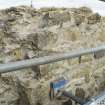
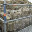
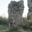
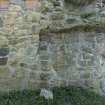
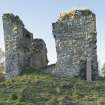
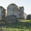
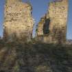
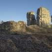
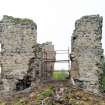
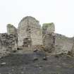
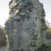
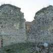
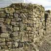
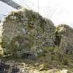
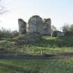
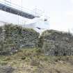
Despite its ruinous condition this castle is of special interest, as it is probably one of the earliest in the county, and certainly one of the most archaic in arrangement. It is situated rather more than a mile north-west of Lochgelly Railway Station, on a mound at the east end of what was formerly a sheet of water, Loch Ore or ‘Inchgall Loch’ (OS. map), drained at the end of the 18th century. De Cardonnel and Grose, writing respectively in 1788 and 1780, both describe the site as a peninsula, but it may well be that it was originally an island, a view supported by the old Gaelic name of the property, which was ‘Inch-gall’ or ‘Isle of the Strangers’ (Normans) . Present appearances suggest that the original castle had been of the mote-and bailey type, and that the mote-hill was reduced in height before the present tower of stone was built. The base of the mound has been enclosed by a barmkin of coursed rubble, now fragmentary and nowhere more than 10 feet in height but still traceable all round. At the north-eastern, north-western, and south-eastern angles there have been small rounded towers, which seem to have been added in the 16th century, and are to-day almost entirely demolished.
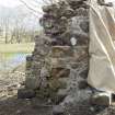
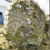
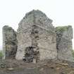
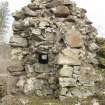
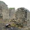
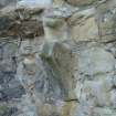
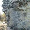
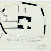
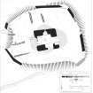
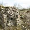
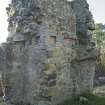
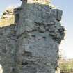
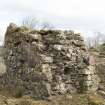
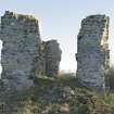
The entrance to the barmkin-enclosure was on the north-west through an arched doorway surmounted, according to De Cardonnel's illustration, by a bretasche set at the wall-head, but the only indication that is left of its position is part of the bar-hole formed in the wall. The enclosure is irregular in shape and measures some 90 feet from north to south by 117 feet from east to west, the wall varying from 3 feet 6 inches to 4 feet in breadth. The tower, dating probably from the 14th century, stands almost in the middle. It is square on plan, measuring 34 ½ feet from north to south by 35 ¼ feet from east to west, and has been at least four storeys in height, although it is now very ruinous, with breaches in all four sides. The walls, which are built of random rubble, are over 9 feet in thickness, and have two external offset courses. There has been a projection on the east face, apparently at the level of the second and third floors only.
The ground floor is filled with debris and is inaccessible. On the first floor is the entrance, which opened from the west into a small lobby within the thickness of the wall. Beyond lay the Hall, which measured 15 ¼ by 17 ½ feet and had a mural chamber beside the door. To east and south are the remains of windows, each with a mural chamber in the ingoing, while a recess in the north wall may have been a fireplace. The second floor, like the first, consisted mainly of a single chamber, which appears to have had a fireplace on the north, a window to south, west, and east, and a vaulted chamber within the eastern projection. All trace of the access from the first floor to the second has vanished, but remains of a stair between the second and third can be seen at the southwest angle of the tower. The third floor is entirely demolished. Except in the small chamber on the second floor, there is no vaulting anywhere.
To north and west of the tower lie the foundations of later outbuildings.
HISTORICAL NOTE. In 1255 David de Lochore is one of the Scottish magnates (1). Later on, the lands came, through an heiress, to the family of Valence (de Valoniis), which also ended in coheiresses, one of whom became the wife of ‘Sir Andrew Wardlaw of Torry, and with her he got Wester-Lochoreshire, or the parish of Ballingry, whose church is an old parsonage at the laird of Lochor's presentation .... Wardlaw of Torrie kept the barony of Lochor (sometimes also called Inchgall) till King Charles I's time, and their chief mansion was the castle of Lochor within the loch of Lochor, consisting of a strong tower and many lower houses, all inclosed with a wall, that is washed with the water of the loch’ (2). In 1662 there is a novodamus charter of the lands of ‘Inchgall’ or Lochore to John ‘Malcomb’ of Balbedie. (Cf. RCAHMS 1933 No. 53.)
RCAHMS 1933, visited 29 May 1928
(1) Bain's Calendar of Docts., &c., i, No. 2013. (2) Sibbald's History of Fife, etc. (ed. 1803), pp.375-5. This edition notes that ‘The Lake of Lochor is now drained’. Cf. The Wardlaws in Scotland, by John C. Gibson, p. 31
Project (November 2014 - August 2015)
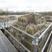
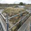
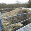
NT 17532 95883 A geophysical survey and excavations were undertaken, November 2014 – August 2015, at Lochore Castle as part of a scheme of community heritage training events for the Living Lomonds Landscape Partnership. Magnetometer, resistivity and ground penetrating radar
surveys were undertaken across the site and island mound. Three trenches were opened around the perimeter of the castle and the former island shoreline. Ongoing conservation works precluded excavation closer to the central tower or within the barmkin. The lower courses of an artillery tower on the barmkin were revealed. A slot was cut across a collapsed section of the barmkin wall. A L-shaped trench investigated the makeup of the island shoreline. Finds included several later medieval pottery sherds, fragments of window glass, a ceramic gaming piece, and part of a carved
stone shot-hole. Large quantities of modern finds were also recovered from redeposited mining waste and landfill related to landscaping in the 1970s. A radiocarbon date from the shoreline deposits suggests occupation on the island during the 10th/11th century AD. A photogrammetry 3D digital model was also generated of the castle prior to conservation works. Scheduled monument consent was granted by Historic Scotland prior to works commencing.
Archive: FCCT, NRHE and Fife Council (intended)
Funder: Heritage Lottery Fund and Historic Environment Scotland
Oliver O’Grady – OJT Heritage
(Source: DES, Volume 17)
Ground Penetrating Radar (November 2014 - August 2015)
NT 17532 95883 Ground penetrating radar, November 2014 – August 2015, at Lochore Castle as part of a scheme of community heritage training events for the Living Lomonds Landscape Partnership.
Archive: FCCT, NRHE and Fife Council (intended)
Funder: Heritage Lottery Fund and Historic Environment Scotland
Oliver O’Grady – OJT Heritage
(Source: DES, Volume 17)
Magnetometry (November 2014 - August 2015)
NT 17532 95883 Magnetometry survey, November 2014 – August 2015, at Lochore Castle as part of a scheme of community heritage training events for the Living Lomonds Landscape Partnership.
Archive: FCCT, NRHE and Fife Council (intended)
Funder: Heritage Lottery Fund and Historic Environment Scotland
Oliver O’Grady – OJT Heritage
(Source: DES, Volume 17)
Resistivity (November 2014 - August 2015)
NT 17532 95883 Resistivity survey, November 2014 – August 2015, at Lochore Castle as part of a scheme of community heritage training events for the Living Lomonds Landscape Partnership.
Archive: FCCT, NRHE and Fife Council (intended)
Funder: Heritage Lottery Fund and Historic Environment Scotland
Oliver O’Grady – OJT Heritage
(Source: DES, Volume 17)
Excavation (November 2014 - August 2015)
NT 17532 95883 Excavations, November 2014 – August 2015, at Lochore Castle as part of a scheme of community heritage training events for the Living Lomonds Landscape Partnership.
Archive: FCCT, NRHE and Fife Council (intended)
Funder: Heritage Lottery Fund and Historic Environment Scotland
Oliver O’Grady – OJT Heritage
(Source: DES, Volume 17)
Field Visit (February 2016 - June 2017)
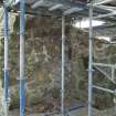
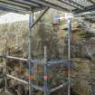
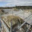
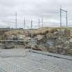
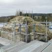
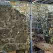
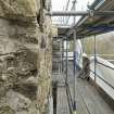
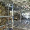
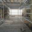
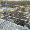
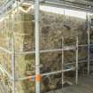
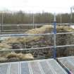
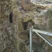
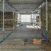
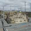
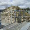
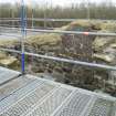
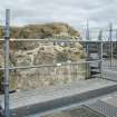
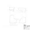
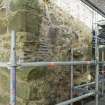
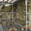
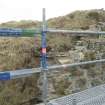
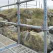
Lochore Castle was resurveyed by HES in 2016-17 at the request of Oliver O’Grady of the Living Lomonds Landscape Partnership project that included excavation and conservation work prior to making the site accessible to the public. Scaffolding erected for this purpose enabled access to the tops of the walls which had not been possible before. Recording included measured survey plans (1:250) and photography at ground, first and second floor levels.
Field Visit (February 2016 - June 2017)
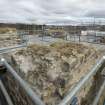
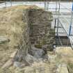
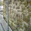
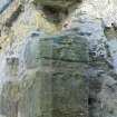
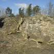
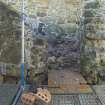
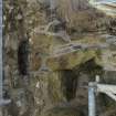
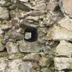
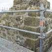
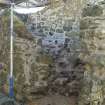
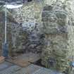
The general assessment of the site has not changed. It occupies what appears to be a mound which is surrounded by a curtain wall that appears to have had round towers added. The dumping of spoil from the nearby coal mine has led to subsidence of the structure under pressure, especially on the SE, which juts out and has had to be conserved on a previous occasion to that in 2016. The mound, however, may be more apparent than real since the basement of the tower is covered by the mound which has presumably been built up against it in the post-medieval period, blocking the basement entrance located in the W wall that was revealed during conservation work. Close examination has shown that the roughly square tower was at least two storeys high and may have had a third floor in view of the well-formed intra-mural stair leading up from the second floor. Chamfered plinths that reduce the size of the upper floors by c 0.15m relieve the line of the rising tower and two small apertures, presumably to drain run off from the roof top were noted on the N and W at second floor level.
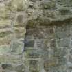
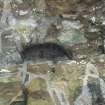
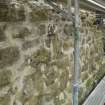
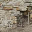
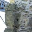
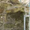
What had been interpreted as a fireplace on the W of the first floor is a stairwell with a gothic arched opening into it from the hall at first floor level. Both first and second floor have recessed fireplaces in the N side and were lit by windows on the S and possibly E, although the enlargement and squaring of the embrasures in the secondary phase have removed the openings in the primary phase at first floor level. At second floor the primary phase, angled ingos are evident to the E, S and W, despite the squared enlargement on the S. The openings in the E had previously been viewed as having some form of projecting turret on the evidence of raggles at second floor level. It is now clear that these projections are for the garderobes that occupied the S side of the opening in the thickness of the wall at both first and second floor. The coombed flags of the ceiling are visible at both levels and an aumbry is visible in the back wall of the chamber at second floor and one side of the stop for the door of the entrance from the main chamber. A recess in the corner of the second floor garderobe, which may be the fortuitous result of conservation, reuses a roughly dressed piece of sandstone that has a segment of a curved opening. The arc of the curve appears too great for a gunloop, but could come from window opening.
Externally there are the footings of ranges of buildings on the N and W, of which that to the W has been built against the tower leaving the cut raggles of two phases of roof line. This building must have provided direct access to the tower at first floor where the entrance passage may be detected with evidence of a coombed slab corbel and a return for a door stop at the inner end of the wall thickness. A separate entrance at ground floor was confirmed during conservation works when the ingo for a passage was revealed towards the N end of the W wall, providing separate basement access. The building on the N does not seem to have been joined to the tower in any visible way and must have been free standing.
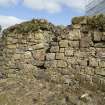
The entrance to the enclosure is marked by the bar slot in the stub of wall on the WNW arc, the length of which indicates that it was a double-width entrance. It may be presumed that a yard occupied the NW corner of the enclosure in the return made by the tower and W range. Traces of two small round towers were still visible on the NE and SW, but gaps on the SE and NW account for the two missing ones that are previously recorded. There is a cell for a garderobe with part of its seating still in place in the thickness of the N curtain wall immediately adjacent to the NE tower. This type of close arrangement of tower and garderobe is more typical of 13th and 14th century work than 16th century towers, as suggested by an earlier authority, and suggests the curtain wall and towers are coeval with the tower. The tower itself may be dated to the 14th century from its gothic arch at the entrance to the stair to the first floor and the relative simplicity of the tower.
Watching Brief (March 2016 - October 2016)
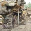
NT 17532 95883 A watching brief, March – October 2016, during underpinning works at Lochore Castle was commissioned by the Living Lomonds Landscape Partnership as a requirement of scheduled monument consent. The excavation of a new electrical duct around the perimeter of the site was also monitored. Four test pits were excavated on the N side of the barmkin wall revealing 0.7m of mining clinker overlying a rubble and sand layer containing medieval pottery. Four further pits were excavated at the base of the tower’s N, NW, NE and SW elevations. Rubble and foundations were exposed in all the pits except the NW pit where a previously unknown cavity was uncovered. Modern infill was excavated to a depth of 0.9m revealing the partial remains of a passageway and inner doorway arch, before works were halted and the pit backfilled. The trench for the duct around the fringes of the site uncovered mainly made-up ground and sand and rubble deposits, except on the S and NE sides where several sherds of medieval pottery were found.
Archive: FCCT, NRHE and Fife Council (intended)
Funder: Heritage Lottery Fund and Historic Environment Scotland
Oliver O’Grady – OJT Heritage

