
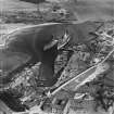
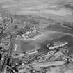
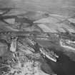
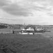
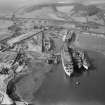
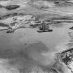
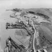
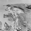
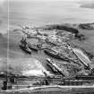
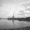
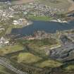
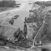
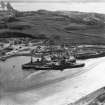
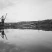
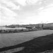
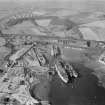
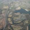
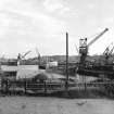
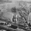
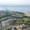
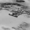
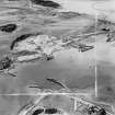
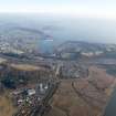
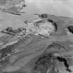
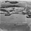
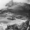
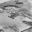
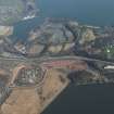
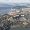
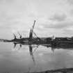
Inverkeithing Bay, Thomas Ward And Sons Shipbreaking Yard


Ship Breaking Yard (20th Century)
Site Name Inverkeithing Bay, Thomas Ward And Sons Shipbreaking Yard
Classification Ship Breaking Yard (20th Century)
Alternative Name(s) Inverkeithing Harbour; Inverkeithing, Cruickness Road, Ward's Shipbreaking Yard
Canmore ID 50918
Site Number NT18SW 113
NGR NT 13000 81985
NGR Description Centred NT 13000 81985
Datum OSGB36 - NGR
Permalink http://canmore.org.uk/site/50918


- Council Fife
- Parish Inverkeithing
- Former Region Fife
- Former District Dunfermline
- Former County Fife
NT18SW 113.00 centred 13000 81985
Shipbreaking Yard [NAT] (at NT 12914 81984 and NT 13069 81975)
OS (GIS) MasterMap, September 2009.
NT18SW 113.01 Centred NT 1289 8184 Yard Offices
NT18SW 113.02 Centred NT 1276 8210 Number 1 and 2 jetties
NT18SW 113.03 Centred NT 1285 8202 Number 3 jetty
NT18SW 113.04 Centred NT 1305 8206 Number 7 jetty
Location formerly entered as NT 130 820.
Site recorded by Maritime Fife during the Coastal Assessment Survey for Historic Scotland, Kincardine to Fife Ness 1996
During October 1999, RCAHMS conducted a photographic survey of Ward's Shipbreaking Yard, in Inverkeithing. The purpose of this survey was to enhance and augment the existing holdings of the National Monuments Record Scotland.
Visited by RCAHMS (MKO), October 1999.

