
Union Canal, Almond Aqueduct


Aqueduct (19th Century)
Site Name Union Canal, Almond Aqueduct
Classification Aqueduct (19th Century)
Alternative Name(s) Lin's Mill Aqueduct; River Almond; Edinburgh & Glasgow Union Canal
Canmore ID 50760
Site Number NT17SW 47
NGR NT 10481 70622
Datum OSGB36 - NGR
Permalink http://canmore.org.uk/site/50760


- Council Edinburgh, City Of
- Parish Kirkliston (City Of Edinburgh/midlothian)
- Former Region Lothian
- Former District City Of Edinburgh
- Former County Midlothian
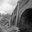
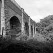
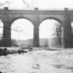
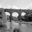
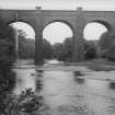
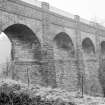
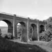
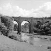
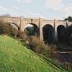
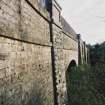
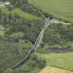
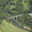
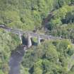
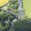
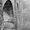
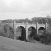
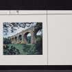
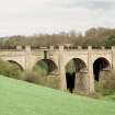
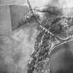
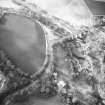
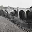
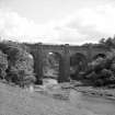
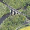
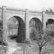
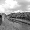
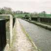
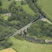
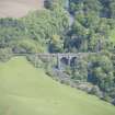
The Union Canal Aqueduct, c.1820, by Hugh Baird sweeps the canal round over the Almond in five great rubbly buttressed arches.
Taken from "West Lothian: An Illustrated Architectural Guide", by Stuart Eydmann, Richard Jaques and Charles McKean, 2008. Published by the Rutland Press http://www.rias.org.uk

NT17SW 47.00 10481 70622
Lin's Mill Aqueduct [NAT]
OS 1:10,000 map [no date available].
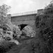
NT17SW 47.01 NT 10555 70578 Toll House
Aqueduct, carrying the [Edinburgh and Glasgow Union] Canal over the River Almond at Lin's Mill. c. 1820.
C McWilliam 1978.
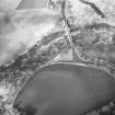
Lin's Mill Aqueduct, built 1820-2, carries the Union Canal (Lin 538) over the River Almond. Designed by Hugh Baird, but modelled on Thomas Telford's aqueduct at Chirk on the Ellesmere Canal, and Telford's advice was sought before this aqueduct was built.
J Lindsay 1968; G Hutton 1993.
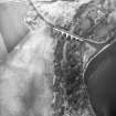
The designer of this simple aqueduct, Baird, consulted Thomas Telford and based the design on the Ellesmere Canal Aqueducts (Chirk and Pontcysyllte), on which the latter had worked. Originally Baird had planned to have a single arch with embankments, but eventually built this 'standard' arched aqueduct. A sluice (NT17SW 178), allowing water to pour into the River Almond below, assists the control of the water level in the canal.
G Hutton 1993.
This aqueduct is clearly marked on the 1st edition of the OS 6-inch map (Edinburghshire 1853, sheet 5), on the current edition of the OS 1:10000 map and on the OS 1:10000 raster map (ND).
Information from RCAHMS (MD), 22 February 2001.
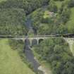
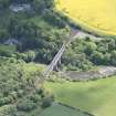
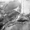
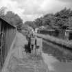
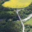
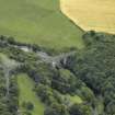
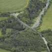
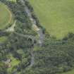
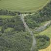
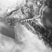
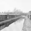
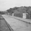
This aqueduct carries the Edinburgh and Glasgow Union Canal over the deep and wooded gorge of the River Almond to the SW of Lin's Mill (NT17SW 11). Its situation and elevation make photography difficult, but the towpath (on the N side of the canal) commands an impressive view to the N. A canal feeder (NT17SW 177) from Cobbinshaw Reservoir (NT05NW 34.00) enters the canal immediately to the E.
Although the entire structure lies within the parish of Kirkliston, the River Almond here forms the boundary between the council areas of West Lothian (to the W) and Edinburgh (to the E).
The location assigned to this record defines the midpoint of the structure. The available map evidence (GIS) suggests that it extends from NT c. 10438 70638 to NT c. 10532 70600.
Information from RCAHMS (RJCM), 3 March 2006.
Photographic Survey (1962)
Photographs of buildings along the Union Canal, West Lothian, by the Scottish National Buildings Record in 1962.
Publication Account (1985)
The Edinburgh and Glasgow Canal was begun in 1818 and the first boat sailed through in 1822. It ran for 50 km from the Port Hopetoun Basin in Edinburgh, following the 73 m contour, before linking with the Forth and Clyde Canal at Camelon (lock 16). It was renowned for its tunnel at Callendar and for its fine aqueducts across the Avon, the Almond and the Water of Leith (NT 220707).
The 5-span Lin's Mill aqueduct suffered an early setback when faulty masonry was detected after construction began in 1819, and the contractors were changed. Like the equally impressive Avon aqueduct (NS 966758) with nearby cottages and stables at Woodcockdale (NS 973760), it incorporated progressive concepts in canal-building. Instead of the much heavier channel of puddled clay, a cast-iron trough carried the water cross the gorge. This was a system pioneered by Thomas Telford for the Pontcysyllte aqueduct in Wales. The light and slender stonework of the piers and arches would not otherwise have been possible.
Other features are the cobbled tow-paths, the milestone at the western end (21 mls to Falkirk; 12.5 to Edinburgh) and the sluices on the aqueduct itself to let any overflow cascade down to the Almond below. There is a small basin either end to allow barges to wait or turni also a feeder stream from the Cobbinshaw reservoir enters the eastern basin through a low stone-arched tunnel. The course of part of this feeder can be traced, high on the side of the gorge, 100 m or so further south.
North from the aqueduct a remarkable sequence of bridges crosses the Almond-the wafer-thin M 8 road bridge built in 1970; the 8-span Birdsmill viaduct (NT 108712) built for the Edinburgh and Bathgate railway in 1849; and the massive 36-span Kirkliston Viaduct (NT 113722) opened in 1842 for the Edinburgh and Glasgow Railway. Its arches and piers were originally
hollow, though filled with concrete in the 1950s to allow for higher speeds.
Elsewhere on the canal there is a pleasing basin at Linlithgow (NT 003769) with a little museum, seasonally, within the former stables. All the original bridges were numbered: a good sequence survives near Hermiston (NT 173703-181705), whilst No. 1 at Viewforth in Edinburgh (NT 243726) incorporates the arms of the cities of Edinburgh and Glasgow on its outer faces. Close by in Edinburgh (NT 244727) stands the distinctive and unusual early 20th century Gilmore Park lifting bridge. It has a rivetted steel framework and a short lifting span. The control cabin is incorporated within the framework and when the bridge was lifted, pedestrians could still cross by the lattice girder footbridge. In 1965, however, the Canal was officially closed.
Information from 'Exploring Scotland's Heritage: Lothian and Borders', (1985).

