
Clackmannan Tower


Castle (Medieval), Tower House (Medieval)
Site Name Clackmannan Tower
Classification Castle (Medieval), Tower House (Medieval)
Alternative Name(s) King's Seat Hill
Canmore ID 48302
Site Number NS99SW 1
NGR NS 90658 91958
Datum OSGB36 - NGR
Permalink http://canmore.org.uk/site/48302


First 100 images shown. See the Collections panel (below) for a link to all digital images.
- Council Clackmannan
- Parish Clackmannan
- Former Region Central
- Former District Clackmannan
- Former County Clackmannanshire
NS99SW 1 90658 91958
See also NS99SW 13.
(NS 9066 9196) Clackmannan Tower (NR)
OS 6" map, (1948).
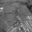
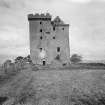
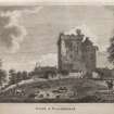
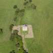
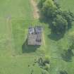
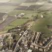
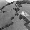
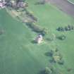
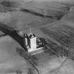
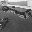
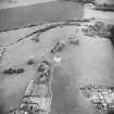
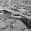
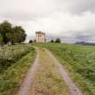
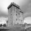
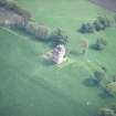
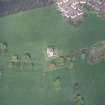
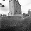
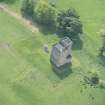
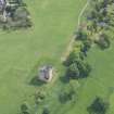
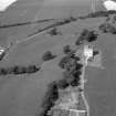
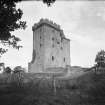
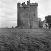
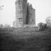
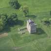
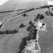
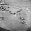
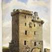
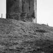
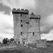
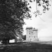
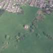
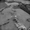
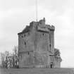
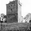
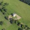
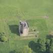
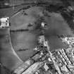
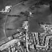
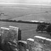
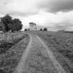
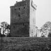
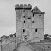
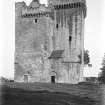
Clackmannan Tower is situated in the summit of a prominent ridge known as King's Seat Hill. The summit has been levelled, and probably at a later period, an area of about an acre has been enclosed as a garden by a wall which has now disappeared. On the southern side are traces of a garden terrace, while a short wide platform lying immediately south of the house, was probably a bowling green. The tower stands at the eastern end of this site.
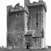
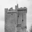
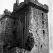
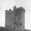
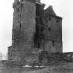
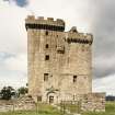
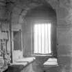
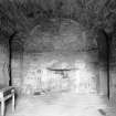
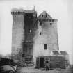
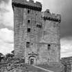
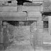
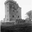
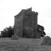
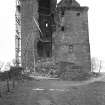
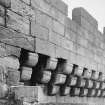
The oldest portion is the lower half of the north end which is part of an oblong tower dating probably from the late 14th century. A wing was added on the south side in the 15th century making the building L-shaped. This wing is five storeys high - one storey higher than the north tower which is surmounted by a cap-house.
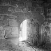
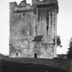
Alterations were made during the 16th and 17th century, and the entrance was transferred from the west wall of the wing to the east in the 17th century.
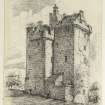
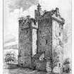
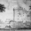
De Cardonnel's view taken in 1788, represents the tower and the forecourt as standing on a mound, with a ditch in front; and slight traces of this ditch are still to be seen. The New Statistical Account (NSA 1845), stated that the tower was surrounded by a moat with drawbridge, while adjoining the tower stood the old mansion, the residence of the Bruce family from between 1365 and 1772.
RCAHMS 1933.
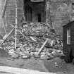
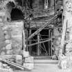
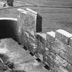
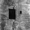
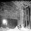
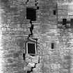
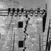
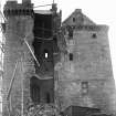
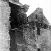
The tower is as described above. Some months ago, as a result of mine-workings, the foundations were affected by subsidence, and a collapse of part of the east side resulted. This is now being repaired by the MoW.
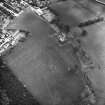
The remains of the moat in front of the tower can still be plainly seen. It is about 15.0m long, 2.0m wide and 1.0m deep.
Visited by OS (WMJ) 5 July 1950.
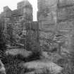
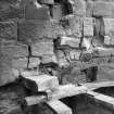
NS 9065 9195 A watching brief was maintained during the excavation of an electricity cable trench at Clackmannan Tower in December 1999. The trench, excavated by a small mechanical excavator, ran between an existing manhole immediately within the remains of a barmkin enclosure on the E side of the tower house. The trench was dug towards the E doorway and measured c 16m E-W, being up to 600mm deep.
Two sherds of reduced post-medieval pottery (jug and handle sherds) were found along with the base of a glass bottle. Initial assessment suggests that these finds date to the 17th century. The present ground level within the E barmkin enclosure is at the same level as the threshold in the E door, while to the S a long range of buildings both defines the S limits of the barmkin, and revets the barmkin terrace. The ground level to the S of this S range is significantly lower than that within the present barmkin.
The findings from the excavation suggest that the present barmkin is the result of landscaping of the natural hill summit, with dumping of material directly over the clean clay horizon. There was no sign of a cobbled surface extant within the barmkin, although a shallow spread of loose stones and small rubble fragments may represent a damaged surface.
Sponsor: Historic Scotland
G Ewart 2000.
NS99SW 1 90658 91958
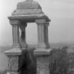
Dates from the 15th century. Oblong in plan, with a short projecting wing, it is 79 feet high, its modern slated roof being gained by a spiral stair; and it retains the cellars, kitchen, barrel-vaulted hall, upper chamber, machicoulis, corbie-stepped gables and bartizan, with a 17th century belfry.
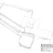
Non-Guardianship Sites Plan Collection, DC23169- DC23171, 1953.
EXTERNAL REFERENCE:
The National Library of Scotland, Edinburgh.
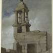
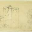
MSS 3241-3 a collection of Sketches made by James Nasmyth, some being by his father, his brother Patrick, and his sister Jane. In volume 3241 is a Sketch, numbered 31, of Clackmannan Tower.
Tradition asserts that Robert the Bruce, was the builder of this Tower in the small town of Clackmannan. In 1359, David II made a grant of it to is kinsman, Sir Robert Bruce. The oldest portion is a typical XIV century tower or Lairds's House, with a small chamber called a cap-house rising above the parapet.
Field Visit (27 June 1928)
Clackmannan Tower.
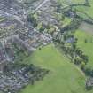
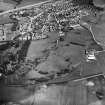
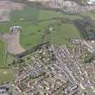
This is one of the most interesting towers included in the present Inventory, in as much as it is structurally complete and in good preservation (SC 723766, SC 1167932). It stands at an elevation of 195 feet above sea level on King’s Seat Hill, a prominent ridge between the Ochils and the Forth, and looks down on Clackmannan from the west. While the hill is nowhere very steep, the incline is gentlest on the east, and the approach is from that quarter. The summit has been levelled and, probably at a late period, an area of about an acre has been enclosed as a garden by a wall that has now disappeared. On the southern side are traces of a garden terrace; while a short, wide platform lying immediately south of the house was probably a bowling green. The building stands at the eastern end of the site.
The oldest portion is the lower half of the north end, which is part of an oblong tower dating probably from the late 14th century. The only entrance was on the first floor. If the original walls were ever carried above that level, the upper part must have been destroyed, for from the second floor upwards the existing walls, which are intaken externally, are undoubtedly the work of a century later and contemporary with a wing which was added on the south side, making the building L-shaped on plan with a re-entrant open to the southwest. As a new kitchen was provided in the wing, the old kitchen, which had occupied the first floor of the original tower, was remodelled as a Hall. A turnpike, rising from the ground level to emerge in the new kitchen, was formed at the re-entrant angle, partly in the new wing and partly in the old tower, in place of the original forest air or ladder. The wing was carried to its present height, one storey above the tower, and was provided with a parapet and walk similar in detail to the embattlement of the main block, an arrangement which was subsequently altered in favour of the present superstructure.
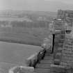
In the 17th century the entrance was transferred from the west wall of the wing to the east and was sheltered by the formation of a forecourt. At the same time a passage or transe leading from the new entrance was cut through the wing from end to end, the lower part of the turnpike, which had been inserted at the second stage, being demolished to make way for it, while on the first floor what had been the stairwell was flagged over and transformed into a passage. To replace the turnpike, a handsome new stair of scale-and-platt type was built at the south-west end of the transe, thus filling in the re-entrant angle. This stair, like its predecessor, rose to the first floor only. Against the north wall of the old tower an outbuilding, now entirely removed, was erected at some time unknown. De Cardonnel's view taken in 1788 represents the tower and the forecourt as standing on a mound with a ditch in front. While the view is inaccurate in certain details, light traces of the ditch are still to be seen in front of the forecourt. In the first and second stages of development there was a barmkin on the west.
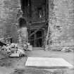
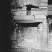
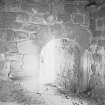
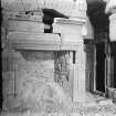
The masonry of the original building is of squared and coursed rubble of grey freestone in courses about lot inches in height, built without pinnings, and that of the main extension is of ashlar, warm in colour, built with oyster-shell pinnings. The north tower shows traces of a heavy splayed basement-course on each wall except the north, where the course may possibly have been removed when the outbuilding was erected. There is an intake course on the walls of the tower above first floor level. On the front or eastern side of the wing is a small splayed basement-course. The east entrance is a Renaissance archway with cornice and pediment but has been reduced in size at a later time. At a high level is a garderobe projection, which clearly belongs to the second stage, as it is nearly, though not immediately, above the third-stage entrance.
[see RCAHMS 1933, 316-319, for a full architectural description]
HISTORICAL NOTE. Robert de Bruce, the King's "cousin," received from David II in 1365 a grant of certain lands within the sheriffdom of Clackmannan (1), and in 1369 the lands of Rait, Perthshire (2). In the reign of Robert III there is a charter grant by Robert Bruce of Rait and Clackmannan (3). "Henry Bruce, Esq., the last laird of Clackmannan, died in 1772; and in him ended the direct line of that ancient family” (4).
RCAHMS 1933, visited 27 June 1928.
(1) Reg. Mag. Sig., I, No. 193. (2) Ibid., No.288. (3) Ibid., p. 642, No. 1889. (4) Stat. Acct., xiv, p. 635.
Measured Survey (June 1943)
Drawings of Clackmannan Tower, Clackmannanshire, by Stanislaw Tyrowicz for the National Buildings Record Scottish Council in 1943.
Field Visit (August 1977)
Clackmannan Tower NS 906 919 NS99SW 1
Tower-house of 14th century date with later additions; faint traces of a
garden terrace are visible to the N. The tower stands on a prominent hill, but is described in 1795 as being surrounded by a moat. Probably site of royal residence of Malcolm IV.
RCAHMS 1978, visited August 1977.
(RCAHMS 1933, pp. 316-19, No. 606; Gordon 1936, 24-51; Simpson and Webster 1972, 185)
Publication Account (1985)
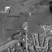
The well-preserved tower-house at Clackmannan stands on the crest of a ridge a short distance to the west of the medieval burgh, and it overlooks the town in much the same way as do the castles in Edinburgh and Stirling. The site first comes on record in 1365 when David II granted certain lands in the Sheriffdom of Clackmannan to Robert de Bruce, and it remained in the hands of the same family until 1772, although by date the tower itself has been abandoned in favour of a more mdoern mansion house.
As might be expected, the building shows signs of several phases of construction, evolving from a simple rectangular tower to a more complex tower-house over a period of three hundred years, and there is some evidence to suggest that the stone structure may have superseded an earlier earthwork castle. The oldest section visible is to be found in the lower half of the north side; it forms part of a rectangular tower dating to the late 14th century, and iwas presumably build soon after the grant of the land to Robert de Bruce. The following century the tower was heightened and wing adde on the south, thus converting it to a conventional L-plan tower lay on the west, in the re-entrant, but, in the 16th or 17th century, it was replaced by the present entrance on the east. This was subsequently ornamented by the find Renaissance archway that can still be seen today, and at approximately the same time, a belfry was added to the caphouseat the top of the turnpike stair. Outside the tower-house a walled forecourt was built in the 17th century, and a view in 1758 shows a ditch surrounding the tower which still survived in part as late as 1795.
At present it is not possible to enter the tower as recent subsidence has led to a partial collapse of the fabric, but this is in the process of being stabilised and made good.
Information from ‘Exploring Scotland’s Heritage: The Clyde Estuary and Central Region’, (1985).
Watching Brief (7 December 1999)
A watching brief was maintained during the excavation of an electricity cable trench at Clackmannan Tower in December 1999. The trench, excavated by a small mechanical excavator, ran between an existing manhole immediately within the remains of a barmkin enclosure on the E side of the tower house. The trench was dug towards the E doorway and measured c 16m E-W, being up to 600mm deep.
Two sherds of reduced post-medieval pottery (jug and handle sherds) were found along with the base of a glass bottle. Initial assessment suggests that these finds date to the 17th century. The present ground level within the E barmkin enclosure is at the same level as the threshold in the E door, while to the S a long range of buildings both defines the S limits of the barmkin, and revets the barmkin terrace. The ground level to the S of this S range is significantly lower than that within the present barmkin.
The findings from the excavation suggest that the present barmkin is the result of landscaping of the natural hill summit, with dumping of material directly over the clean clay horizon. There was no sign of a cobbled surface extant within the barmkin, although a shallow spread of loose stones and small rubble fragments may represent a damaged surface.
Sponsor: Historic Scotland
G Ewart
Kirkdale Archaeology
Ground Survey (24 November 2008)
Survey of the garden at Clackmannan Tower.
Project (2008 - 2012)
A number of surveys were carried out to produce illustrations for inclusion in the RCAHMS 2012 publication; Scotland's Lost Gardens: From the Garden of Eden to the Stewart Palaces. ISBN-10: 1902419812, ISBN-13: 978-1902419817
Watching Brief (19 March 2013 - 21 March 2013)
NS 9080 9191 (centred on) A watching brief was undertaken, 19–21 March 2013, during alterations to three gates to allow disabled access to the tower. Evidence of recent landscaping and utilities were seen but nothing of archaeological significance was recorded.
Archive: RCAHMS (intended)
Funder: Historic Scotland
Paul Fox, Kirkdale Archaeology, 2013
(Source: DES)
OASIS ID: kirkdale1-311422
Watching Brief (11 October 2018 - 15 October 2018)
NS 90654 91943 A watching brief was undertaken, 11–15
October 2018, during creation of a beacon (seating bench and
interpretation panels) within the scheduled area to the S of
Clackmannan Tower. No finds or features of archaeological
significance were recorded.
Archive: NRHE (intended)
Funder: Inner Forth Landscape Initiative
John Gooder – ACCESS Archaeological Condition Services
(Source DES, Volume 19)

