
Ayr, Barns Of Ayr


Battle Site (13th Century)
Site Name Ayr, Barns Of Ayr
Classification Battle Site (13th Century)
Canmore ID 41786
Site Number NS32SW 19
NGR NS 3398 2168
Datum OSGB36 - NGR
Permalink http://canmore.org.uk/site/41786


- Council South Ayrshire
- Parish Ayr
- Former Region Strathclyde
- Former District Kyle And Carrick
- Former County Ayrshire
NS32SW 19 3398 2168.
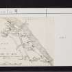
(NS 3398 2168) Site of the (NAT) Barns of Ayr (NR)
OS 25" map (1937)
In 1297 Sir William Wallace surprised a superior English force resting in temporary barracks in the Barns of Ayr, which he set on fire and killed all those who emerged (W Dodd 1972). The barns were no doubt the common building where the corn belonging to the people of Ayr was stored (J Paterson 1847); they are supposed to have stood between Mill and Kyle Street, near the Old Quarry (Name Book 1856). Pryde's map moves the site N, to about NS 340 217. The traditional account of the burning is from "The Wallace" by Blind Harry, some time before 1488. He is an unreliable authority (Marquess of Bute 1878).
This alleged site is now completely built upon.
Visited by OS (JLD) 28 December 1955

