
Clyde Defences, Portkil Battery, Landward Defences, Aiden Hill, No 1 Position


Blockhouse(S) (First World War), Trench(S) (First World War)
Site Name Clyde Defences, Portkil Battery, Landward Defences, Aiden Hill, No 1 Position
Classification Blockhouse(S) (First World War), Trench(S) (First World War)
Canmore ID 41479
Site Number NS28SW 5
NGR NS 23521 81160
NGR Description Centred at NS 23521 81160
Datum OSGB36 - NGR
Permalink http://canmore.org.uk/site/41479


- Council Argyll And Bute
- Parish Rosneath
- Former Region Strathclyde
- Former District Dumbarton
- Former County Dunbartonshire
It is likely that this earthwork is part of one of the blockhouses marked on maps of 1916 showing the outer defences of Portkil Battery during the First World War. The Aiden Hill defences were marked as 'No. 1 Position' and comprised a blockhouse (No.1) at NS 23533 81132, a second blockhouse (No. 2) at NS 23508 81194, trenches at NS 23372 81405 and NS 23444 80991, and an 'Officers' Shelter' at NS 23675 81400 (half way between this group and the next, to the north. The group was linked by telephone to the battery.
Information from HS/RCAHMS World War One Audit Project (GJB) 15 July 2013.
Field Visit (August 1977)
Aiden Hill NS 235 812 NS28SW
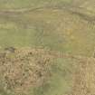
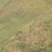
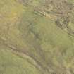
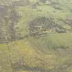
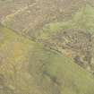
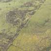
Situated at a height of 140m OD and in a commanding position at the S end of the Rosneath peninsula there are the remains of a rectilinear earthwork of unknown date and purpose. All that survives are the N and W corners and the NW side, which measures 26m in length and stands to a height of 1.5m.
RCAHMS 1978, visited August 1977
Project (March 2013 - September 2013)
A project to characterise the quantity and quality of the Scottish resource of known surviving remains of the First World War. Carried out in partnership between Historic Scotland and RCAHMS.
Field Visit (26 September 2016)
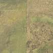
The First World War defences at the SW end of the summit of Aiden Hill form part (No.1 Position) of a larger infrastructure designed to protect the Portkil Coastal Battery (NS28SE 39) from its landward side (see also NS28SW 30, NS28SE 39.15-17). Aiden Hill is a low ridge given over to both improved and rough pasture, and it originally supported two ‘Positions’ – No. 1 at its SW end and No. 2 (NS28SE 39.15) some 340m to the NE.
No.1 Position comprised two blockhouses (No.1 and No.2), and two firing trenches set 260m to the NW and 140m to the SSW respectively. Blockhouse No.1 (NS c.2352 8110) stood on the SE flank of the ridge and no remains of it were positively identified in an area of rank vegetation on the date of visit. Blockhouse No.2 (NS 23489 81171) stood on the highest part of this area of the SW end of the ridge and, whilst there was visible on the date of visit a low scarp describing a fragment of a roughly circular feature measuring about 7m in overall diameter, this lay at least 13m NE of the position of the structure as recorded on an annotated War Department map (National Archives: WO78/4396). The only element of No. 1 Position that was positively identified on the date of visit was the firing trench (NS 23355 81358) on the crest of the ridge with an outlook to the west. It comprises a narrow and shallow trench some 24.5m in length which is fronted (on the W) by a flat-topped mound of upcast measuring about 2.5m in thickness and 0.4m high at the front.
Situated some 270m NE of Position No.1 and 160m S of Position No.2, are the remains of an ‘Officer’s Shelter’ (WO78/4396) now marked by a grass-grown rectangular area of hard standing measuring at least 6.2m from WE to SE by 3.3m transversely. The SW side and the two ends of this area are defined by very shallow outer-facing scarps: the NE side is lost beneath the upcast of a drain that now marks the NE end of the improved field in which the hut stood.
Visited by HES, Survey and Recording (JRS, AK, AM) 26 September 2016.

