|
Prints and Drawings |
KBD 26/1 |
|
Drawing showing details of doorways, fireplace and windows of
Barholm Castle, Carsluith Castle, Craigmillar Castle and Montsode Castle.
Elevations (1":2') and details (1/4 full-size) |
1880 |
Item Level |
|
|
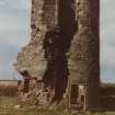
Photographs and Off-line Digital Images |
A 78891 CN |
Records of the Ordnance Survey, Southampton, Hampshire, England |
View from E. |
1982 |
Item Level |
|
|
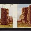
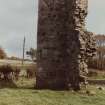
Photographs and Off-line Digital Images |
A 78893 CN |
Records of the Ordnance Survey, Southampton, Hampshire, England |
General view. |
1982 |
Item Level |
|
|
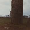
Photographs and Off-line Digital Images |
A 78892 CN |
Records of the Ordnance Survey, Southampton, Hampshire, England |
View from SW. |
1982 |
Item Level |
|
 |
On-line Digital Images |
SC 1257953 |
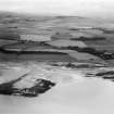
Records of Aerofilms Ltd, aerial photographers, Bristol, England |
Ardrossan, general view, showing Eglinton Road and Montefode Farmhouse. Oblique aerial photograph taken facing north-east. |
2/9/1935 |
Item Level |
|
 |
On-line Digital Images |
SC 1257972 |
Records of Aerofilms Ltd, aerial photographers, Bristol, England |
Ardrossan, general view, showing Ardrossan Road and Montefode Farmhouse. Oblique aerial photograph taken facing north-east. |
2/9/1935 |
Item Level |
|
 |
On-line Digital Images |
SC 2421951 |
Records of the Ordnance Survey, Southampton, Hampshire, England |
Montfode Castle, NS24SW 1, Ordnance Survey index card, page number 2, Verso |
1958 |
Item Level |
|
 |
On-line Digital Images |
SC 2421952 |
Records of the Ordnance Survey, Southampton, Hampshire, England |
Montfode Castle, NS24SW 1, Ordnance Survey index card, page number 1, Recto |
1958 |
Item Level |
|
 |
On-line Digital Images |
SC 2421953 |
Records of the Ordnance Survey, Southampton, Hampshire, England |
Montfode Castle, NS24SW 1, Ordnance Survey index card, page number 2, Verso |
1958 |
Item Level |
|
 |
On-line Digital Images |
SC 2421954 |
Records of the Ordnance Survey, Southampton, Hampshire, England |
Montfode Castle, NS24SW 1, Ordnance Survey index card, Recto |
1958 |
Item Level |
|
 |
On-line Digital Images |
SC 2421955 |
Records of the Ordnance Survey, Southampton, Hampshire, England |
Montfode Castle, NS24SW 1, Ordnance Survey index card, page number 1, Recto |
1958 |
Item Level |
|
 |
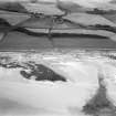
On-line Digital Images |
SC 2535016 |
Records of the Ordnance Survey, Southampton, Hampshire, England |
View from E. |
1982 |
Item Level |
|
 |
On-line Digital Images |
SC 2535017 |
Records of the Ordnance Survey, Southampton, Hampshire, England |
View from SW. |
1982 |
Item Level |
|
 |
On-line Digital Images |
SC 2535018 |
Records of the Ordnance Survey, Southampton, Hampshire, England |
General view. |
1982 |
Item Level |
|
|
Photographs and Off-line Digital Images |
BS 86/3 CS |
Historic Scotland Archive Project |
Miscellaneous photographs: caravan and Montfode Castle. |
30/8/1985 |
Batch Level |
|
|
All Other |
551 166/1/1 |
Records of the Ordnance Survey, Southampton, Hampshire, England |
Archaeological site card index ('495' cards) |
1947 |
Sub-Group Level |
|


