
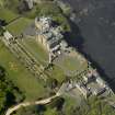
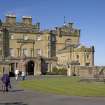
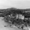
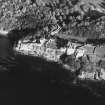
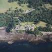
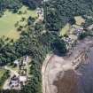
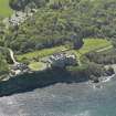
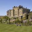
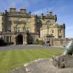
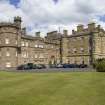
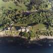
Culzean Castle


Castle (18th Century), Country House (18th Century), Steps (Medieval) - (Post Medieval), Tower House (18th Century), Wall (Medieval) - (Post Medieval)
Site Name Culzean Castle
Classification Castle (18th Century), Country House (18th Century), Steps (Medieval) - (Post Medieval), Tower House (18th Century), Wall (Medieval) - (Post Medieval)
Alternative Name(s) Culzean Castle Policies; Culzean Country Park
Canmore ID 40959
Site Number NS21SW 1
NGR NS 23265 10285
Datum OSGB36 - NGR
Permalink http://canmore.org.uk/site/40959


First 100 images shown. See the Collections panel (below) for a link to all digital images.
- Council South Ayrshire
- Parish Kirkoswald
- Former Region Strathclyde
- Former District Kyle And Carrick
- Former County Ayrshire
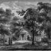
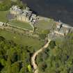
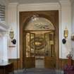
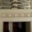
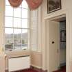
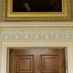
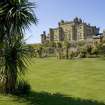
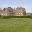
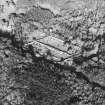
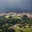
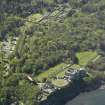
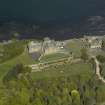
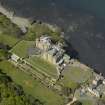
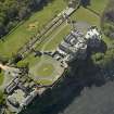
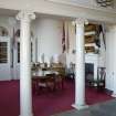
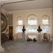
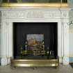
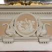
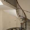
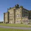
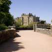
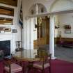
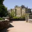
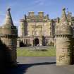
A castle is thought to have stood at Culzean since the 12th century. The earlier castle was transformed in 1775, when the architect Robert Adam began substantial remodelling work for the 10th Earl of Cassilis. Adam, who was also responsible for the castle's interiors, home farm and stables, incorporated parts of the older structure into the main range of a grand mansion which made dramatic use of its cliff top location. The addition of the west wing in 1879 gave the castle its current form. It is now in the care of the National Trust for Scotland and is open to the public.
Information from RCAHMS (SC) 7 August 2007
NS21SW 1.00 23265 10285
(NS 2326 1027) Culzean Castle (NAT)
(NS 2340 1019) Sentry Rooms (NR) (In Ruins)
OS 6" map (1910).
(NS 2326 1027) Culzean Castle (NAT)
(1777) on site of (NAT) Castle (NR)
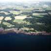
(NS 2323 7029) Culzean Coves (NR)
OS 1:10000 map (1972).
NS21SW 1.01 NS 23237 10020 Camellia House
NS21SW 1.02 NS 235 101 Road
NS21SW 1.03 Cancelled
NS21SW 1.04 23451 10314 Gasworks
NS21SW 1.05 Centred NS 2328 1029 Culzean Coves, Main Cavern System
NS21SW 1.06 Centred NS 2337 1033 Culzean Coves, Stables Caves System
NS21SW 1.07 24135 10317 Laigh Whiteston Lodge
NS21SW 1.08 24143 10331 Hoolity Ha Bridge
NS21SW 1.09 23315 10316 Sundial
See also:
NS21SW 31 NS 2312 1026 Culzean Harbour
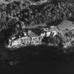
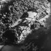
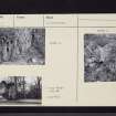
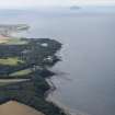
From the 12th to the early 17th century, Culzean was one of a number of small castles of the Kennedy family. It occupied a strong position on top of cliffs, with a steep valley and escarpments defending the landward side. A series of caves in the rock beneath contained "two dainty spring wells". In the hands of a cadet branch before it became the seat of the head of the family in the mid-18th century, it remained a comparatively modest and typical Scots tower house. Its outline is known from an old drawing. From this and from the description of Sir William Brereton, who visited the house in 1635, it is safe to assume the usual arrangement of an L-shaped tower with vaulted service quarters on the ground floor, a single great hall occupying the whole of the first floor, and a cluster of small private apartments on the floors above.
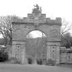
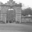
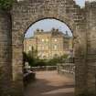
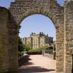
In 1693, the castle is described as "flanked on the south with very pretty gardens and orchards, adorned with excellent tarrases". These last are the oldest surviving features, apart from the caves. The old castle was remodelled by Robert Adam for David, 10th Earl of Cassilis, starting in 1775. The S front was built up, incorporating some of the masonry of the old tower in the main block; wings were added to E and W. After some years, the drum tower on the edge of the cliff was added, and the central well was filled in. Adam's work included the stable buildings, also the mock ruined arch and causeway which now form the main approach to the castle ("Sentry Rooms" on OS 6" 1910). In 1879, the castle took its final form with the addition of the W wing on the site of Adam's brewhouse.
R Prentice 1976
Culzean Castle is as described above. The fortified caves mentioned above can still be seen at NS 2327 1030, just above high water mark. They are in good condition but there is no longer a through passage to the castle (Glasgow Spelaeological Soc Newsletters, October and
December 1966).
Visited by OS (JLD) 3 December 1955 and (RD) 7 March 1967
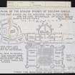
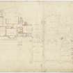
The central range of Culzean Castle incorporates the remains of the 16th century and earlier castle, and is not built on the site of it. The attached copy of a Robert Adam plan of 1785 (Portfolio of past architect and survey plans held by NTS, Culzean Castle) shows the original castle, measuring overall some 43ft by 26ft with walls much altered but retaining a thickness of about 6ft. It became the Eating Room, and is now the library, but perambulation confirmed that most of the original fabric, apart from the rebuilt S wall, must be intact to at least the present first floor level, although it is entirely encased by Adam's later work. Before the major alterations and additons of the 18th century the castle had evidently beeen extended firstly to the N and then to the E and W. The assumed L-shape is not apparent on the 1785 plan.
Visited by OS (JRL) 9 June 1977.
Site recorded from draft text of Discovery and Excavation in Scotland 1996 (ref: 96/506), held by Council for Scottish Archaeology.
CSA 1997
NS 233 103 Monitoring of services installation in the vicinity of Culzean Castle, the Carriage Circle, Clocktower Court and Gazebo Court revealed that the area from the castle to Clocktower Court had been cut down to clean whin bedrock as part of Robert Adam's remodelling of the complex in the late 18th century. The Gazebo Court had seen some deposition of fill, also part of Adam's works. No surviving remains of the pre-existing fortified complex were identified.
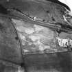
An architectural record was made of the gazebo at Gazebo Court in advance of building repair works. The feature was erected around 1780 by Robert Adam as part of his enhancement of the clifftop setting of his recreated Culzean Castle. While appearing as a buttressed and battlemented clifftop wall tower from the beach below, the structure actually saw use as an abattoir, as a tethering ring, and a possible location of slaughter block, a well-drained flagstone floor and corbels to support a substantial carcass-hanging beam would confirm.
While roofless and derelict at the time of survey, the apsidal-ended structure still retained much internal wall plaster, dooks indicating dado boarding and fixing points for the roof structure.
A report will be lodged with the NMRS.
Sponsor: National Trust for Scotland
T Addyman 1998
NS 232 102 The original kitchens of Culzean Castle (NMRS NS20NW 1) were recorded during conservation works in March 1999. A number of significant features were recorded including the early flue arrangement relating to stewing stoves within the apsidal NE end of the kitchen. A historical assessment related the original construction to the first phase of Robert Adam's reconstruction of Culzean of around 1777, although there were significant design changes during building. Further modification occurred to the SW part of the kitchen (the scullery) during construction in c 1785. A receipt from Carron Company, dated 1790, may relate to the fitting out of the kitchen.
Sponsor: National Trust for Scotland.
T Addyman 2000
NS 231 102 Assessment and architectural recording was undertaken during conservation works in June 1999.
Dolphin House. A structure of three principal phases, the original as a laundry in the manner and material of other Robert Adam-designed buildings at Culzean (c 1775-1800) and perhaps to a design by Adam himself, or perhaps by his clerk of works, Hugh Cairncross. The structure faced away from the beach (and the lordly bathing area), being lit on that side (NW) by a single Venetian window. The structure was originally symmetrical in general form - the central block of three bays being flanked by smaller wings of equal size. The original construction includes the incorporation of an earlier, bolection-moulded fire surround within the room in the NE wing. The arrangement of the fenestration of the central block, however, was not symmetrical and the principal entrance was off-set. This was perhaps recovered from demolished pre-Adam parts of the castle (early/mid-18th century). Additions were made to the NE flanking wing, being extended by 2m, and then abutted by a later 19th-century outbuilding. In the mid-20th century extensive modification of the structure occurred, with multiple windows inserted in the sea-facing elevation (cementitious surrounds modelled to mimic the originals) and various plastic repairs to external dressings elsewhere. Internally the structure was wholly reordered with, particularly, the insertion of a staircase and a first floor within the central block.
Bath House. Externally arranged as a gothic folly formed of substantial blocks of local whin with rustic windows of sandstone. Internally a concrete floor and ceiling structure were removed during conservation works, revealing the bedding for a sandstone flag floor and an internal arrangement consisting of a major ashlar-lined bathing tank and a much smaller stone-lined (?plunge) tank. Evidence of the original roof structure was also recorded.
Records were also made of other associated structures:
Two cisterns. On the sloping ground above the Dolphin House to the S. Provided water for both the laundry and the bath house; the entrances of each were subsequently cut down.
Changing House. A circular structure built of fine ashlar with an ogival roof.
Sea water pool. Stone-lined pool below high water mark.
Building platform. On the rising ground some 50m to the E of the Dolphin House. Rubble-built retaining wall some 0.5m high on the downslope side, cut into the upslope side. No structural remains visible above.
Sponsor: National Trust for Scotland.
T Addyman 2000
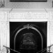
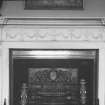
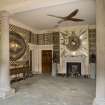
NS 234 104 Building recording was undertaken of the surviving elements of the original library. These included the S wall of the present dining room; ex situ fireplaces and over-mantel mirrors; glass-fronted library cabinets relocated in the present entrance vestibule, and one in storage from which was traced part of Adam's original colour scheme.
Sponsor: National Trust for Scotland.
T Addyman 2001.
NS21SW 1.00 23265 10285
NS21SW 1.01 23237 10020 Camellia House
NS21SW 1.02 235 101 Road
NS21SW 1.03 23 10 Trial Excavations
NS21SW 1.04 23451 10314 Gasworks
NS21SW 1.05 2328 1029 Culzean Coves, Main Cavern System
NS21SW 1.06 2337 1033 Culzean Coves, Stables Caves System
NS21SW 1.07 24135 10317 Laigh Whiteston Lodge
NS21SW 1.08 24143 10331 Hoolity Ha Bridge
NS21SW 1.09 23315 10316 Sundial
See also:
NS20NW 15 22260 09501 Pagoda
NS20NW 20 22087 09097 Ardlochan Lodge
NS20NW 21 22718 09832 Ice-house
NS20NW 35 23126 09845 Walled Garden
NS20NW 38 24018 09580 Kennels
NS20NW 39 22464 09511 Swan Pond Cottage
NS20NW 40 22895 09234 Cat Gates
NS20NW 55 24478 09986 Glenside Lodge (now demolished)
NS20NW 81 22797 09995 Powder House
NS20NW 96 23097 09894 Gardener's Cottage
NS20NW 97 22466 09487 Aviary
NS20NW 98 22489 09654 Swan Pond
NMRS Reference: Bob Heath, Architect, has identified NMRS photograph AYD/43/82 as a copy of a drawing for the original hypocaust heating system at the Camelia House at Culzean c.1817. See correspondence with NMRS 24 February 1998 'Having just reglazed the building I can confirm that there is every evidence that this plan was adhered to.'
NMRS Printroom
W Schomberg Scott Photograph Collection
13 views of the Fountain Court in winter
5 views of the Home Farm (10 prints - many duplicates)
2 elevations and plan for the Home Farm ('Farm Office') - all 3 duplicated.
18 detailed views of furniture and china cabinet displays, most of them duplicated.
Acc no 1997/39.
NMRS (Sch. Scott Plans)
Miscellaneous drawings
National Library of Scotland
Newhailes Album
MS 25673-8
A series of photograph albums compiled by the Countess of Cassilis and her sister, Lady Newhailes with their home at Ardwell, their marriages, views of family houses, many exterior views of Culzean, the Earl as a barrister, their house at 1 Moray Place and much related ephemera c.1900-.
NMRS Printroom
A series of 14 vignettes of Scottish Country Houses, Churches and Castles. Mounted on modern leaves removed from an album. Purchased from Ewan Lamont, Candlemaker row, October 1987. Purchased on account of the view of Craigcrook. They are Us with Nd but must have been executed.1820-35. Mounted on sheets 13 1/2" x 9".
2 Vignettes of Culzean Castle.
One Insc: 'Colzean House, Wm White, Surgeon del' as published in 1802 in: 'An elegant Collection of Interesting Views in Scotland'. The other labelled: 'Colzean Castle Ayrshire'.
NMRS 'Culzean Castle, Stable Tower, Clock and Caves' by Eric J. Hosie, manuscript notes. NMRS Manuscripts.
NMRS Correspondence and notes relating to discoveries (caves) at Culzean Castle. c.1966-1968. NMRS Manuscripts.
NMRS Inventory to Culzean Castle Drawings, Typescript. NMRS Library.
Architects:
Robert Adam 1777-79
James Donaldson 1808 - design for coach-house
Robt. McLachlan 180( ) - plan of coach house
Robertson Buchanan - engineer - battery designs
Robert Lugar - Swan Cottage after 1808
James Gillespie Graham 1815 - designs for lodges
Richard Crichton 1815 -design for a lodge
Alexander Naysmith - design for a lodge
John Thin 1796 - designs for lodges & gateways
Hugh Caincross - 1796 - design for a wooden bridge
NMRS: Survey by J & J Carrick, Ayr 1973 -plans, elevations & sections of Home farm
NMRS: Survey by Ian G. Lindsay & Partners -plans & elevations of the Swinton gate
NMRS: Copies of Soane Museum drawings, Vols 1, 14, 20, 23, 37 & 53 - photographs of plans, elevations, sections & details
NMRS: Survet by J and J Carrick, Atr 1973 - Plans elevations and sections of Home Farm.
NMRS: Survey by Ian G Lindsay and Partners - Plans elevations of the Swinton gate.
Museum of Western Art, Oxford (Sir Bruce Ingram Collection) Robert Adam - perspective view (Watercolour)
Sothebys 'Aitkin Sale' 30-31 July 1934 - design for ceiling of 1st drawing room, Copy in NMRS.
NMRS:
'Ayrshire, 1745-1950' - pp 63 and 260.
SMT Magazine, March, 1951.
NMRS: Plans: I G Linsday Collection, W/343.
W/158.
CULZEAN CASTLE DRAWINGS
A large collection of drawings for Culzean Castle including designs for a villa for James Kennedy by James Adam 1755; designs for Culzean Castle by Robert Adam 1777-1779 and 1787 with related designs for chimneypieces, glasses etc. design for a ruined bridge by Robert Adam 1787 and many designs for estate buildings by James Gillespie Graham 1815 and Robert Lugar etc.
Deposited by the National Trust for Scotland 1990
NMRS photographic survey 1973 Inventory 52
RIBA: Blackadder plans.
Photography was carried out in 2009 on behalf of the Buildings of Scotland series.
RCAHMS (CAJS) 2009.
Design (1775 - 1787)
Design (1953 - 1957)
Photographic Survey (March 1954)
Photographic survey by the National Buildings Record Scottish Council in March 1954.
Field Visit (3 December 1955)
Culzean Castle is as described above. The fortified caves mentioned above can still be seen at NS 2327 1030, just above high water mark. They are in good condition but there is no longer a through passage to the castle (Glasgow Spelaeological Soc Newsletters, October and
December 1966).
Visited by OS (JLD) 3 December 1955 and (RD) 7 March 1967
Photographic Survey (1955)
Photographic Record (1960 - 1980)
Field Visit (7 March 1967)
Culzean Castle is as described above. The fortified caves mentioned above can still be seen at NS 2327 1030, just above high water mark. They are in good condition but there is no longer a through passage to the castle (Glasgow Spelaeological Soc Newsletters, October and
December 1966).
Visited by OS (JLD) 3 December 1955 and (RD) 7 March 1967
Field Visit (9 June 1977)
The central range of Culzean Castle incorporates the remains of the 16th century and earlier castle, and is not built on the site of it. The attached copy of a Robert Adam plan of 1785 (Portfolio of past architect and survey plans held by NTS, Culzean Castle) shows the original castle, measuring overall some 43ft by 26ft with walls much altered but retaining a thickness of about 6ft. It became the Eating Room, and is now the library, but perambulation confirmed that most of the original fabric, apart from the rebuilt S wall, must be intact to at least the present first floor level, although it is entirely encased by Adam's later work. Before the major alterations and additons of the 18th century the castle had evidently beeen extended firstly to the N and then to the E and W. The assumed L-shape is not apparent on the 1785 plan.
Visited by OS (JRL) 9 June 1977.
Field Visit (November 1982)
Culzean Castle NS 232 102 NS21SW 1
An L-plan tower-house is incorporated in the late 18th-century mansion of Culzean Castle. The entrances to a system of caves in the cliffs below the castle are blocked by masonry of late-medieval date.
RCAHMS 1983, visited November 1982
(Grose 1789-91, ii, 209-10; Paterson 1863-6, ii, 294-5; Brown 1891, 156-7; Macfarlane 1906-8, ii, 9, 21; The Glasgow Spelaeological Society Newsletter, October and December 1966; NMRS, AYD/43/50-1).
Publication Account (1985)
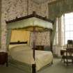
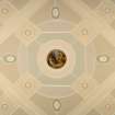
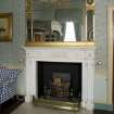
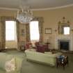
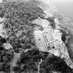
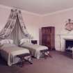
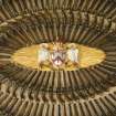
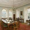
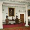
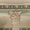
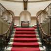
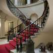
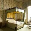
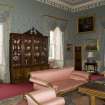
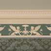
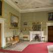
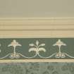
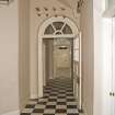
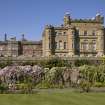
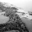
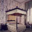
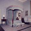
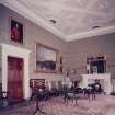
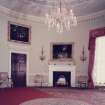
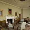
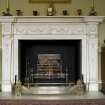
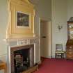
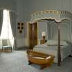
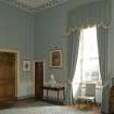
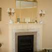
Culzean (pronounced Culain) is one of Scotland's greatest country houses and is renowned for its Adam interiors, magnificenrgardens and Country Park. Formerly the principal seat of the Kennedy family, it was gifted to the National Trust for Scotland in 1945. Since then the house has been extensively restored both internally and externally; in 1969, the policies were created a Country Park with the Home Farm subsequently converted into a Park Centre containing an exhibition hall, restaurant, shop and a ranger office which provides guided walks through the park.
Until the mid 18th century Culzean was a simple late medieval tower-house, but from the 1760s to the 1780s the 9th and 10th Earls of Cassillis carried out a series of alterations which transformed the castle and the surrounding policies. The 9th Earl extended the accommodation, but the major work began in 1777 when the 10th Earl commissioned Robert Adam to remodel the house. Adam not only redesigned the building but was also responsible for the whole of the interior decoration, including much of the furniture and fittings. Since the National Trust took over the castle the Adam plasterwork and colour schemes have been faithfully restored, and Culzean is now a showpiece for Adam's work in Scotland. Building at the castle did not come to an end with Adam, and the growing demands for space by the family of the 14th Earl (the 3rd Marquis of Ailsa, 1848- 1938) led to the reconstruction of the West Wing in 1879.
Surrounding the house there is a series of gardens set within the 565 acres of policies bequeathed by the 5th Marquis. References to 'pretty gardens .... with excellent terraces' go back to the 1690s, and these doubtless formed the basis for the present formal garden known as the Fountain Court, to the south of the house. Specialised buildings such as the flamboyant Gothic Camellia House and the Orangery were added to cater for exotic plants, and on a more mundane level the large walled kitchen garden was built to provide fruit and vegetables for the house. Around the more formal sections of tl1e gardens, there are wilder areas containing specimen trees, shrubs and a lake (the Swan Pond) for waterfowl.
Besides working on the house, Robert Adam also designed the Home Farm (1777); this unusual range of buildings is set around a courtyard which is entered through an arched gateway. These have been restored and now form the visitor centre for tl1e Country Park; among the facilities is an exhibition hall which displays items relating to the house and estate, as well as explaining the agricultural improvements that were introduced to Ayrshire in the 18th and 19th centuries.
Information from ‘Exploring Scotland’s Heritage: The Clyde Estuary and Central Region’, (1985).
Fabric Recording (1998)
NS 233 103 Monitoring of services installation in the vicinity of Culzean Castle, the Carriage Circle, Clocktower Court and Gazebo Court revealed that the area from the castle to Clocktower Court had been cut down to clean whin bedrock as part of Robert Adam's remodelling of the complex in the late 18th century. The Gazebo Court had seen some deposition of fill, also part of Adam's works. No surviving remains of the pre-existing fortified complex were identified.
An architectural record was made of the gazebo at Gazebo Court in advance of building repair works. The feature was erected around 1780 by Robert Adam as part of his enhancement of the clifftop setting of his recreated Culzean Castle. While appearing as a buttressed and battlemented clifftop wall tower from the beach below, the structure actually saw use as an abattoir, as a tethering ring, and a possible location of slaughter block, a well-drained flagstone floor and corbels to support a substantial carcass-hanging beam would confirm.
While roofless and derelict at the time of survey, the apsidal-ended structure still retained much internal wall plaster, dooks indicating dado boarding and fixing points for the roof structure.
A report will be lodged with the NMRS.
Observation (1999)
NS 232 102 The original kitchens of Culzean Castle (NMRS NS20NW 1) were recorded during conservation works in March 1999. A number of significant features were recorded including the early flue arrangement relating to stewing stoves within the apsidal NE end of the kitchen. A historical assessment related the original construction to the first phase of Robert Adam's reconstruction of Culzean of around 1777, although there were significant design changes during building. Further modification occurred to the SW part of the kitchen (the scullery) during construction in c 1785. A receipt from Carron Company, dated 1790, may relate to the fitting out of the kitchen.
Observation (1999)
NS 231 102 Assessment and architectural recording was undertaken during conservation works in June 1999.
Dolphin House. A structure of three principal phases, the original as a laundry in the manner and material of other Robert Adam-designed buildings at Culzean (c 1775-1800) and perhaps to a design by Adam himself, or perhaps by his clerk of works, Hugh Cairncross. The structure faced away from the beach (and the lordly bathing area), being lit on that side (NW) by a single Venetian window. The structure was originally symmetrical in general form - the central block of three bays being flanked by smaller wings of equal size. The original construction includes the incorporation of an earlier, bolection-moulded fire surround within the room in the NE wing. The arrangement of the fenestration of the central block, however, was not symmetrical and the principal entrance was off-set. This was perhaps recovered from demolished pre-Adam parts of the castle (early/mid-18th century). Additions were made to the NE flanking wing, being extended by 2m, and then abutted by a later 19th-century outbuilding. In the mid-20th century extensive modification of the structure occurred, with multiple windows inserted in the sea-facing elevation (cementitious surrounds modelled to mimic the originals) and various plastic repairs to external dressings elsewhere. Internally the structure was wholly reordered with, particularly, the insertion of a staircase and a first floor within the central block.
Bath House. Externally arranged as a gothic folly formed of substantial blocks of local whin with rustic windows of sandstone. Internally a concrete floor and ceiling structure were removed during conservation works, revealing the bedding for a sandstone flag floor and an internal arrangement consisting of a major ashlar-lined bathing tank and a much smaller stone-lined (?plunge) tank. Evidence of the original roof structure was also recorded.
Records were also made of other associated structures:
Two cisterns. On the sloping ground above the Dolphin House to the S. Provided water for both the laundry and the bath house; the entrances of each were subsequently cut down.
Changing House. A circular structure built of fine ashlar with an ogival roof.
Sea water pool. Stone-lined pool below high water mark.
Building platform. On the rising ground some 50m to the E of the Dolphin House. Rubble-built retaining wall some 0.5m high on the downslope side, cut into the upslope side. No structural remains visible above.
Observation (2001)
NS 234 104 Building recording was undertaken of the surviving elements of the original library. These included the S wall of the present dining room; ex situ fireplaces and over-mantel mirrors; glass-fronted library cabinets relocated in the present entrance vestibule, and one in storage from which was traced part of Adam's original colour scheme.
Sponsor: National Trust for Scotland.
Watching Brief (2006)
NS 2325 1013, NS 2345 1027, NS 2329 1024
A series of watching briefs were undertaken around the area close to the castle. New drainage ditches were cut to allow run-off next to re-surfaced roads on the Dolphin House Brae and the service drive. No artefacts or deposits were found on the former site (NS 2325 1013) although a topographic survey of the adjacent terraces was undertaken. At the latter site (NS 2345 1027) traces of an earlier, stone-built, road-side drain were recorded. A further watching brief was undertaken while re-surfacing the path on the middle terrace of the Fountain Court terraced garden (NS 2329 1024) but no archaeological remains were discovered.
Report to be lodged with the NTS SMR and NMRS (intended).
Sponsor: the National Trust for Scotland
D Alexander 2006
Watching Brief (19 April 2007 - 20 April 2007)
NS 23350 10282 A watching brief was conducted on 19-20 April 2007 during the laying of a new drainage pipe along the western verge down from the Armorial Arch to the start of the viaduct. Stripping turf revealed an area of stone and mortar rubble. The trench was expanded and revealed a stone wall 0.6m wide and at least three courses high built onto the sloping bedrock. This wall runs obliquely underneath the main wall flanking the entrance passageway up from the viaduct. This latter wall probably dates to the Robert Adam work of the 1790s and the newly discovered wall underneath may have been part of the older courtyard wall.
Archive to be deposited with the NTS SMR and RCAHMS.
Funder: The National Trust for Scotland.
D Alexander 2007
Photographic Survey (3 November 2008 - 12 May 2009)
Trial Trench (27 July 2009 - 29 July 2009)
NS 2327 1030 As part of a BBC Alba programme on archaeology, ‘Talamh Trocair’, trial trenching was carried
out at Culzean Castle on 27–29 July 2009 to examine the possible route down the cliff face to the caves below. Due to the steepness of the slope and the proximity of the cliff edge Ian McHardy, an archaeologist with roped access skills, was brought in to carry out the work. A small area 3 x 1m was excavated close to the cliff edge, at the base of a slope/ramp that may have dog-legged round to the upper cave entrance. Topsoil 0.3–0.5m deep was cleared from the bedrock and revealed five irregular breaks in the bedrock that appear to form a rough set of steps. Artefacts recovered included a range of 19th-century material and a sherd of the neck and handle of green glazed reduced ware jug of probable 16th-17th century date.
Archive: RCAHMS (intended)
Funder: The National Trust for Scotland and BBC Alba
Derek Alexander and Ian McHardy – The National Trust for Scotland
Geophysical Survey (26 November 2013 - 27 November 2013)
NS 23265 10285 The Fountain Court of Culzean Castle was originally a wide and deep natural gully which was infilled and levelled in the 18th century. The area contained a bowling green befo re the fountain was built in 1876. A geophysical survey was undertaken, 26–27 November 2013, which aimed
to map drainage features in the court and provide information to help address a persistent drainage problem.
The GPR survey conducted with a 500MHz antenna, with data collected at 0.02m intervals along traverses 0.5m apart on an orthogonal grid, located a complex network of presumed drainage features, with the data suggesting various phases of drainage systems throughout the site. More substantial services also appear to have been located within the area.
Numerous, more amorphous, anomalies were also noted, mostly towards the eastern and western limits of the survey area, which are thought to indicate localised variations in the subsoil due to landscaping activity.
Archive: Rose Geophysical Consultants
Funder: The National Trust for Scotland
Susan Ovenden – Rose Geophysical Consultants
(Source: DES)
Archaeological Evaluation (18 February 2014 - 27 March 2014)
Three test pits were examined corresponding to the location for concrete footing from a proposed outfall pipe. The archaeological works took place on a steep bank on the shore immediately to the north-west of Culzean Castle. No archaeologically significant deposits and no in-situ structural remains were uncovered during the course of this work. No archaeologically significant anthropic material was recovered.
Information from OASIS ID: rathmell1-184850 (T Rees) 2014.
Watching Brief (24 February 2016 - 27 May 2016)
Archaeological monitoring works were carried out in respect to the insertion of a new outfall pipe at Culzean Castle. The archaeological works were designed to mitigate the impact on the archaeological remains within their development area. The works did not reveal the presence of any significant archaeological features or in situ structural remains within the excavated areas. The pipe started in the garden to the immediate rear of the castle, and only met modern made ground surrounding the insertion of the sceptic tank. As it ran down the slope, it exposed 20th century dumped material which had likely been cast down the slope during an earlier phase of refurbishments to the castle. With the possible exception of one small area near to the top of the slope, the works did not reach deeper than these deposits and did not reveal the underlying natural subsoil.
Information from OASIS ID: rathmell1-244217 (C Williamson) 2016

