 |
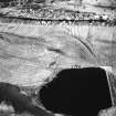
On-line Digital Images |
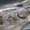
DP 062676 |
RCAHMS Aerial Photography Digital |
General oblique aerial view looking toward the Upper Kelspoke Reservoir, taken from the W. |
6/2/2009 |
Item Level |
|
 |
On-line Digital Images |
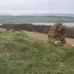
DP 067266 |
RCAHMS Field Survey Digital Photography |
Detail view of walling of Kelspoke Castle, taken from S. |
17/3/2009 |
Item Level |
|
 |
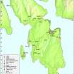
On-line Digital Images |
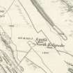
SC 1154507 |
|
Extract of OS 1st edition map of North Kelspoke. |
1869 |
Item Level |
|
 |
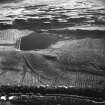
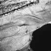
On-line Digital Images |
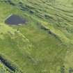
DP 069910 |
RCAHMS Aerial Photography Digital |
General oblique aerial view centred on the remains of rig and furrow cultivation, taken from the N. |
23/6/2009 |
Item Level |
|
 |
On-line Digital Images |
DP 097423 |
Records of the Royal Commission on the Ancient and Historical Monuments of Scotland (RCAHMS), Edinbu |
Map - Distribution of Early Historic and Medieval sites and artefacts. |
8/2010 |
Item Level |
|
 |
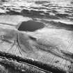
On-line Digital Images |
SC 1724133 |
RCAHMS Aerial Photography |
Oblique aerial view. |
1993 |
Item Level |
|
 |
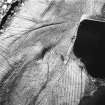
On-line Digital Images |
SC 1724134 |
RCAHMS Aerial Photography |
Oblique aerial view. |
1993 |
Item Level |
|
 |
On-line Digital Images |
SC 1724141 |
RCAHMS Aerial Photography |
Oblique aerial view. |
1993 |
Item Level |
|
 |
On-line Digital Images |
SC 1724142 |
RCAHMS Aerial Photography |
Oblique aerial view. |
1993 |
Item Level |
|
 |
On-line Digital Images |
SC 1724143 |
RCAHMS Aerial Photography |
Oblique aerial view. |
1993 |
Item Level |
|
 |
On-line Digital Images |
SC 2421053 |
Records of the Ordnance Survey, Southampton, Hampshire, England |
Bute, Kelspoke Castle, NS15SW 1, Ordnance Survey index card, page number 1, Recto |
1958 |
Item Level |
|
 |
On-line Digital Images |
SC 2421054 |
Records of the Ordnance Survey, Southampton, Hampshire, England |
Bute, Kelspoke Castle, NS15SW 1, Ordnance Survey index card, page number 2, Verso |
1958 |
Item Level |
|


