
Arran, Brodick Home Farm


Standing Stone(S) (Prehistoric)
Site Name Arran, Brodick Home Farm
Classification Standing Stone(S) (Prehistoric)
Alternative Name(s) Cladach; Mossend; Estate Office
Canmore ID 40152
Site Number NS03NW 3
NGR NS 00613 37447
NGR Description NR c. 006 374
Datum OSGB36 - NGR
Permalink http://canmore.org.uk/site/40152


- Council North Ayrshire
- Parish Kilbride
- Former Region Strathclyde
- Former District Cunninghame
- Former County Buteshire
Desk Based Assessment (13 March 1973)
NS03NW 3 c006 374.
(A: NS 0060 3744, B: NS 0062 3743, C: NS 0071 3743) Standing Stones (NR) OS 6" map, (1924)
Stone 'A', oriented 70 degrees E of S, is 11 ft 6 ins x 2 ft 6 ins x 1ft 10ins. Stone 'B', oriented NW-SE, is 8ft 11 ins x 2ft x 2ft. Stone 'C', oriented 65o E of S, is 7ft 10ins x 2ft 2ins x 1ft 2ins. 'A' is 71ft form B and 306ft from C. These three stones, of red sandstone, are not on the circumference of a circle.
Information from OS (IF) 13 March 1973
Source: J Balfour 1910.
Field Visit (24 October 1977)
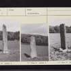
Three standing stones situated in level regularly cultivated land.
NS 0061 3744: 'A' is a sandstone slab 3.6m high, 0.6m broad and 0.5m thick.
NS 0063 3744: 'B' of similar rock to 'A' is 2.3m high with a triangular base of 0.5m length sides.
NS 0072 3743. 'C' of similar rock to the others it is 2.5m high 0.6m broad and 0.3m thick.
Surveyed at 1:2500. Photographed.
Visited by OS (T R G) 24 October 1977.
Note (30 July 2018)
The location, classification and period of this site have been reviewed.
HES Survey and Recording 30 July 2018.

