
Brainport Bay


Platform(S) (Period Unassigned), Standing Stone(S) (Prehistoric)
Site Name Brainport Bay
Classification Platform(S) (Period Unassigned), Standing Stone(S) (Prehistoric)
Canmore ID 40011
Site Number NR99NE 10
NGR NR 975 951
Datum OSGB36 - NGR
Permalink http://canmore.org.uk/site/40011


- Council Argyll And Bute
- Parish Kilmichael Glassary
- Former Region Strathclyde
- Former District Argyll And Bute
- Former County Argyll
NR 975 951 (centred on) Two standing stones on the easternmost, shoreside platform of the main alignment were vandalised during June. Both stones which act as pointer stones for observing the sunrise at the summer solstice, were knocked out of their sockets and one of the stones smashed beyond repair. The broken stone has been replaced with a stone of similar dimensions and the intact fallen stone re-erected in its former position. Both stones have been embedded in concrete into their sockets and their packing stones reinstated.
Sponsor: Historic Scotland
F Baker 1994a.
The archive generated by the investigation and reconstruction of the 'standing stones' in 1994 has been catalogued.
Historic Scotland Archive Project
Field Visit (May 1986)
NR99NE 10 976 951.
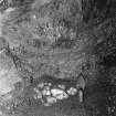
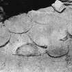
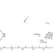
Excavations undertaken at a group of stone-built platforms at Brainport Bay have produced artefacts and a series of radiocarbon dates, which provide information about the chronological span of the site; the following account is based on the published account. The higher platform (a) - designated the Back Platform by the excavator - is set above the upper level of the raised beach 120m from the shore; it was originally about 24m in width, but it has been partly destroyed by forestry ploughing. To the seaward (NE) side of the platform there is a small rectangular extension measuring about 2m by 2.3m; it was carefully constructed of slabs and boulders and covered by an even scatter of fragments of white quartz. Amongst the latter there were several flint flakes, as well as a core and a pointed implement of the same material. To the SW of the platform there is an earthen bank (not itself necessarily ancient) about 50m in length and up to 3m in thickness; charcoal from the soil buried beneath it, however, provided a radiocarbon determination of 1060 BC +/- 80 (GU-1705). Between the higher and lower platforms there is a group of boulders, including one particularly massive block over 2m in height.
An impressive group of platforms (b and c) - designated the Terraces and Causeway - is situated close to the shore and about 70m NE of the Back Platform; these were built against a rocky outcrop aligned NE and SW, with a central cleft on the same alignment. The main stone-built platform is D-shaped on plan and has been carefully constructed with a boulder kerb; it measures about 9.5m across the chord of the D. There are two further small platforms, one butting the SW edge of the main one and the other, some 3.3m across, adjoining the outcrop at the centre of the chord. A stone that was found lying on the main platform has since been erected about 5.5m to the ENE of its former position. A second slab was found on the N side of the platform.
Activity on the outcrop itself was represented by areas of burning, some paving, a hearth, a pit which yielded a radiocarbon date of AD 976 +/- 74 (GU-1000), and a stone-filled trench containing a small quantity of charcoal, dated to AD 335 +/- 55 (GU-1703); the finds from the outcrop included quartz and two pieces of flint (a core and a scraper). A further charcoal deposit on the paved area yielded a date of AD 135 +/- 55 (GU-1434). A third stone (1.28m long and 0.45m by 0.09m) found lying on the outcrop has since been erected nearby. Charcoal found in ash on the old ground surface close to the stone-socket was dated to AD 440 +/- 60 (GU-1595).
The site has been interpreted as a centre for solar observation in prehistoric times, but the identification must be treated with some reserve, since the archaeological evidence is at best equivocal; there is no doubt, however, that the objects discovered and the radiocarbon dates obtained represent a range of activities from prehistoric to Early Historic times associated with structures that are not in themselves readily explicable.
The two natural boulders designated Oak Bank Stone and Car Park Stone in the published report and the large slab situated to the E of the site were examined on several occasions during the Commission's survey and it was concluded that none could be identified as fallen standing stones.
RCAHMS 1988, visited May 1986
(Gladwin 1975; 1985; E W MacKie 1981).

