
Dunamuck


Standing Stone(S) (Prehistoric)
Site Name Dunamuck
Classification Standing Stone(S) (Prehistoric)
Alternative Name(s) Dunamuck North; Dunamuck 1
Canmore ID 39584
Site Number NR89SW 28
NGR NR 84711 92914
Datum OSGB36 - NGR
Permalink http://canmore.org.uk/site/39584


- Council Argyll And Bute
- Parish Kilmichael Glassary
- Former Region Strathclyde
- Former District Argyll And Bute
- Former County Argyll
NR89SW 28 8470 9290.
(NR 8471 9290) Standing Stones (NR)
OS 6" map, Argyllshire, 2nd ed., (1924)
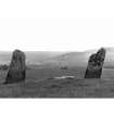
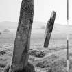
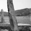
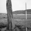
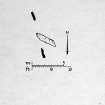
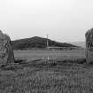
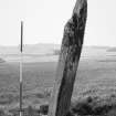
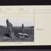
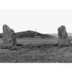
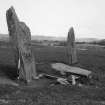
Three stones, the central one fallen, in a line facing E.
(1) measures 9' x 4'8", leaning W
(2), fallen to SE, is 12'3" x 2'3" x 2'7"
(3) is 7'6" x 4'6".
The distance 1 - 3 is 14'10".
M Campbell and M Sandeman 1964.
The three stones are as described. Their alignment is NNW-SSE. Resurveyed at 1:2500.
Visited by OS (WDR) 27 April 1973.
No change to the report of 27 April 1973.
Surveyed at 1/2500.
Visited by OS (BS) 15 February 1977.
Field Visit (May 1983)
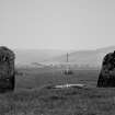
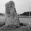
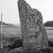
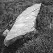
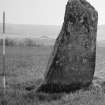
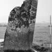
There are three groups of standing stones situated NW and NE of Dunamuck on the level ground on the W side of the River Add.
The first group, comprising three stones, of which the central one has fallen, is situated about 750m NNE of Dunamuck (Campbell and Sandeman 1964). The two upright stones are 4.4m apart, with their longer axes aligned roughly NNW and SSE. The most northerly stone measures 2.63m in height and 1.35m by 0.35m at ground level. The fallen stone measures 3.75m by 0.8m and 0.3m in thickness. The third stone is almost 3m high and measures 1.6m by 0.35m at the base.
Visited May 1983
RCAHMS 1988

