
Clochkeil, Kintyre


Standing Stone(S) (Prehistoric)
Site Name Clochkeil, Kintyre
Classification Standing Stone(S) (Prehistoric)
Canmore ID 38405
Site Number NR62SE 15
NGR NR 6577 2445
Datum OSGB36 - NGR
Permalink http://canmore.org.uk/site/38405


- Council Argyll And Bute
- Parish Campbeltown
- Former Region Strathclyde
- Former District Argyll And Bute
- Former County Argyll
NR62SE 15 6577 2445.
(NR 6577 2445) Standing Stones (NAT)
OS 6" map (1924)
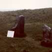
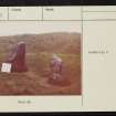
Standing Stones: a group of three stones in a small hollow among the sand-dunes. The largest stone stands 1.91m in height with its longer axis aligned NNW and SSE; it measures 1.4m by 0.6m at the base, and rises with a gradual taper to a pointed top. The second stone, 3m to the ENE, measures 0.8m by 0.5m at ground level and stands to a height of 1.4m. The third stone has fallen, and now lies largely embedded in the ground about 2.7m SE of the second stone. When the soil was cleared away from it in 1930 it was found to be 2.1m long and 0.74m by 0.5m in maximum breadth and thickness respectively.
Colville (1930) notes that the relative positions of the stones suggest that they may have formed part of a stone circle.
RCAHMS 1971, visited 1960
The standing stones are as described by RCAHMS. No firm judgement as to whether they formed part of a stone circle can be made.
Surveyed at 1:10 000.
Visited by OS (JB) 31 October 1977

