
Jura, Sannaig


Standing Stone(S) (Prehistoric)
Site Name Jura, Sannaig
Classification Standing Stone(S) (Prehistoric)
Canmore ID 38247
Site Number NR56SW 4
NGR NR 51841 64816
Datum OSGB36 - NGR
Permalink http://canmore.org.uk/site/38247


- Council Argyll And Bute
- Parish Jura
- Former Region Strathclyde
- Former District Argyll And Bute
- Former County Argyll
NR56SW 4 5184 6480
(NR 5184 6480) Standing Stone (NR)
OS 6" map, Argyllshire, 2nd ed., (1900)
This standing stone is 7ft 4ins high, 1ft 8ins to 1ft 6ins wide and 10ins thick. A number of stones lying 10ft S suggest very strongly the remains of a cist. Among a number of smaller stones, two are conspicuous, one 3ft 10ins by 2ft, and the other, which may have been another monolith or part of the cist, measures 6ft 4ins by 1ft 3ins. There are many loose stones hereabouts; they may have been gathered from the fields, or may form the residue from a cist (sic: ?cairn intended). These stones lie within a semi-cultivated enclosure.
E H Rideout 1932.
The standing stone, now within thickly planted conifers, is as described, as are the two other stones specified which lie just north. On the south side of the standing stone is a prostrate slab measuring 2.6m long by 0.5m broad by 0.35 thick. The only "loose" stone noted consists of two or three squarish blocks and, more numerous, some rubble, but none suggestive of a cairn and/or cist.
Surveyed at 1/10,000.
Visited by OS (J M) 14 May 1978.
Field Visit (May 1976)
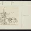
NR 518 648. What has been an alignment of three standing stones is situated about 300m NE of Sannaig farmhouse between the edge of a Forestry Commission plantation and a turf wall and is overlooked by higher ground immediately to the NW.
Stone A, now fallen, measures 2.6m in length, 0.6m in breadth and at least 0.4m in thickness.
Stone B, the only one still upright and intact, is 2.2m high; measuring 0.55m by 0.25m at the base with the longer axis running NNW and SSE, it has straight sides and a pointed top.
Only the stump of stone C remains in position, rising 0.3m above ground level will its long axis aligned E and W; a recumbent fragment (D) however, measuring 0.45m by 0.35m and 1.9m in length, may be its upper portion.
A flat slab (E), measuring 1.2m in length by 0.8m in breadth and 0.2m in thickness, does not appear to be a fallen standing stone, but may possibly be a displaced cist-cover.
On the N side of the turf wall there is at upright stone 0.8m high which has probably been put in position in comparatively recent times.
RCAHMS 1984, visited May 1976
Measured Survey (1976)
RCAHMS surveyed the standing stones at Sannaig at a scale of 1:100. The plan was redrawn in ink and later published at a reduced scale (RCAHMS 1984 fig. 70E).

