|
Photographs and Off-line Digital Images |
B 34001 CN |
|
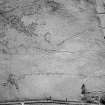
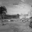
Mappa Britanniae Faciei Romanae. Plate II from "Military Antiquities of the Romans in Britain" |
1793 |
Item Level |
|
|
Photographs and Off-line Digital Images |
B 34002 CN |
|
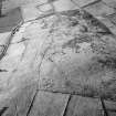
Albion et Hibernia. Plate III from "Military Antiquities of the Romans in Britain" |
1793 |
Item Level |
|
|
Photographs and Off-line Digital Images |
A 998 PO |
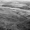
Cambridge University Collection for Aerial Photography |
Oblique aerial view |
1989 |
Item Level |
|
|
Photographs and Off-line Digital Images |
A 999 PO |
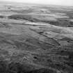
Cambridge University Collection for Aerial Photography |
Oblique aerial view |
1989 |
Item Level |
|
|
Photographs and Off-line Digital Images |
B 34040 CN |
Copies from a collection of drawings assembled by the Society of Antiquaries of London, London, Engl |
Plan of Agricola's camp called Rae Dykes near Ury about 3 miles from Stone-Haven. Plate L from 'Military Antiquities of the Romans in Britain'. |
1793 |
Item Level |
|
|
Photographs and Off-line Digital Images |
B 34040 CS |
Copies from a collection of drawings assembled by the Society of Antiquaries of London, London, Engl |
Plan of Agricola's camp called Rae Dykes near Ury about 3 miles from Stone-Haven. Plate L from 'Military Antiquities of the Romans in Britain'. |
1793 |
Item Level |
|
|
Photographs and Off-line Digital Images |
KC 1194 PO |
Cambridge University Collection for Aerial Photography |
Oblique aerial view |
1953 |
Item Level |
|
|
Photographs and Off-line Digital Images |
KC 1195 PO |
Cambridge University Collection for Aerial Photography |
Oblique aerial view |
1955 |
Item Level |
|
|
Photographs and Off-line Digital Images |
KC 1196 PO |
Cambridge University Collection for Aerial Photography |
Oblique aerial view |
|
Item Level |
|
|
Photographs and Off-line Digital Images |
KC 1197 PO |
Cambridge University Collection for Aerial Photography |
Oblique aerial view |
|
Item Level |
|
|
Photographs and Off-line Digital Images |
KC 1198 PO |
Cambridge University Collection for Aerial Photography |
Oblique aerial view |
|
Item Level |
|
|
Photographs and Off-line Digital Images |
KC 785 PO |
Cambridge University Collection for Aerial Photography |
Oblique aerial view |
1954 |
Item Level |
|
|
Photographs and Off-line Digital Images |
KC 786 PO |
Cambridge University Collection for Aerial Photography |
Oblique aerial view |
|
Item Level |
|
|
Photographs and Off-line Digital Images |
KC 787 PO |
Cambridge University Collection for Aerial Photography |
Oblique aerial view |
|
Item Level |
|
|
Photographs and Off-line Digital Images |
B 68854 |
|
'Plan relative to the account of Agricola's Engagement with Galgacus.' Plan opposite page 565 from Archaeologia Scotica Vol. I. |
1792 |
Item Level |
|
 |
On-line Digital Images |
SC 1010249 |
Records of Aberdeen Aerial Surveys, Aberdeen, Scotland |
Oblique aerial view centred on the remains of the Roman temporary camp and cairnfield at Raedykes and Garrison Hill, looking to the E. |
19/7/1985 |
Item Level |
|
 |
On-line Digital Images |
SC 1010250 |
Records of Aberdeen Aerial Surveys, Aberdeen, Scotland |
Oblique aerial view centred on the remains of the Roman temporary camp and cairnfield at Raedykes and Garrison Hill, looking to the NNW. |
19/7/1985 |
Item Level |
|
 |
On-line Digital Images |
SC 1010251 |
Records of Aberdeen Aerial Surveys, Aberdeen, Scotland |
Distant oblique aerial view centred on the remains of the Roman temporary camp and cairnfield at Raedykes and Garrison Hill, looking to the SSW. |
19/7/1985 |
Item Level |
|
 |
On-line Digital Images |
SC 1010253 |
Records of Aberdeen Aerial Surveys, Aberdeen, Scotland |
Oblique aerial view centred on the remains of the Roman temporary camp and cairnfield at Raedykes and Garrison Hill, looking to the SSW. |
19/7/1985 |
Item Level |
|
|
Photographs and Off-line Digital Images |
SC 1164087 |
|
Plan of Agricola's camp called Rae Dykes near Ury about 3 miles from Stone-Haven. Plate L from 'Military Antiquities of the Romans in Britain'. |
1793 |
Item Level |
|
|
Manuscripts |
MS 36/177 |
Records of the Royal Commission on the Ancient and Historical Monuments of Scotland (RCAHMS), Edinbu |
Field notebook of K A Steer (RCAHMS). 'S10 - Forfar, Kincardine'. |
7/1956 |
Item Level |
|
 |
Digital Files (Non-image) |
WP 000776 |
Records of the Royal Commission on the Ancient and Historical Monuments of Scotland (RCAHMS), Edinbu |
Scanned copy of RCAHMS Marginal Land Survey unpublished typescripts (Kincardine-shire). |
1953 |
Item Level |
|
 |
Digital Files (Non-image) |
WP 003878 |
Publications by the Royal Commission on the Ancient and Historical Monuments of Scotland |
Exploring Scotland's Heritage: Aberdeen And North-East Scotland |
1996 |
Item Level |
|
 |
Digital Files (Non-image) |
WP 003890 |
Publications by the Royal Commission on the Ancient and Historical Monuments of Scotland |
Exploring Scotland's Heritage: Grampian |
1986 |
Item Level |
|


