
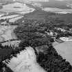
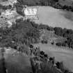
Crathes, Warren Field


Timber Hall
Site Name Crathes, Warren Field
Classification Timber Hall
Alternative Name(s) Crathes Castle Policies
Canmore ID 36670
Site Number NO79NW 17
NGR NO 7393 9670
Datum OSGB36 - NGR
Permalink http://canmore.org.uk/site/36670


- Council Aberdeenshire
- Parish Banchory-ternan
- Former Region Grampian
- Former District Kincardine And Deeside
- Former County Kincardineshire
NO79NW 17 7393 9670.
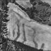
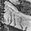
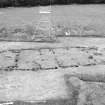
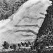
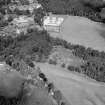
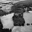
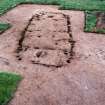
Cropmarks reveal what is probably the wall-trench of a rectangular timber building 500m ESE of Crathes Castle (NO79NW 8.00); the building measured at least 20m in length by 10m in breadth, and two probable pits on the long axis of the structure may indicate the positions of roof-supports.
I B M Ralston 1982; RCAHMS 1984.
NO 739 967 A programme of geophysical survey was carried out by post-graduate students at Glasgow University in April and May 2000 to investigate the rectangular structure (NMRS NO79NW 17) observed in aerial photographs in Warren Field within the estate of Crathes Castle. The resistivity survey reassuringly confirmed the presence of this structure (c 23 x 11m) with some associated post-holes. However, as a result of its very poor state of preservation, no progress was made in resolving its Dark Age or Neolithic attribution.
R Jones 2000.
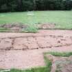
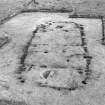
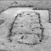
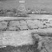
NO 739 967 An excavation was intended to evaluate the nature of cropmarks identified by aerial photography in 1976, and to assess the nature and survival of the evidence as a tool for future management of the site. Two main features were investigated: a large timber building (NO79NW 17) and part of a nearby pit alignment. The building, of which around a quarter of the plan was revealed, appears to have been c 9 x 20m, constructed with large oak timbers. It is broadly similar to the roughly contemporary Neolithic sites of Balbridie, Aberdeenshire and Claish, Stirling, but with differences in detail of the plan.
Environmental sampling revealed barley, emmer and bread/club wheat, and a possible grain of spelt. Finds include Neolithic pottery, flint and carbonised fragments of worked wood, several of which appear decorated.
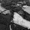
Some 30m of a pit alignment was revealed, c 150m from the building. One of the pits in the alignment was excavated to examine the fill and sample material for dating.
The main range of radiocarbon dates for the site fall within the period 3800-3700 BC. On the present evidence it would appear that the building and the pit alignment were contemporary. As there are a large number of more ephemeral features visible on the aerial photographs between the building and the alignment, it is possible that more of the wider Neolithic landscape survives on the site.
Archive to be deposited in the NMRS.
Sponsors: HS, NTS, Aberdeenshire Council, Prehistoric Society.
H K Murray, J C Murray 2004
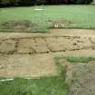
NO 739 967 (building); NO 737 966 (pit alignment) The site was first recognised in 1976 as a series of cropmarks revealed by aerial photography. In 2004, a two-week assessment excavation (DES 2004, 11) demonstrated that these cropmarks represented a well-preserved Early Neolithic building (NO79NW 17) and a contemporary pit alignment (NO79NW 18), both yielding radiocarbon dates in the range c 3800-3700 BC. A more intensive season of excavation was undertaken in May and June 2005, with three main aims: to reveal the full plan of the building and investigate
its structure; to fully examine the pit alignment; and to investigate cropmarks in the area between the building and the alignment.
The Warren Field building was c 24 x 9m externally and 22.5 x 8m internally. However, there is a possibility that the W segment of the structure, which was less substantial, may have been an unroofed area or may have been dismantled during the life of the building, with the roofed part of the building being c 18.5 x 8m internally. The interior was further sub-divided by a series of partitions. The main entrance was to the NE, with two narrow gaps between the timbers in the side walls possibly providing light and air to the inner rooms.
The outer walls were built of large oak timbers set vertically in segmented foundation trenches. The bases of the timbers had been charred before construction and, as the building had been subsequently destroyed by fire, the burnt post-pipes were in most cases very clear so it was possible to see that both round and split timbers had been used. The internal partitions had been constructed of lighter timbers and there is clear evidence that some of them had been replaced or augmented by new timbers set alongside. Two large pits lay on the longitudinal axis of the building: their function is unclear but they do not appear to have held roof supports.
Preliminary analysis of the finds distribution indicates that there was little activity in the possibly open area at the extreme W end. Within the main area of the structure there was a concentration of flint artefacts to the W, with a lower concentration at the E end, and very few flints in the central area. The distribution of pottery was in
reverse, with little to the W and an increasing concentration towards the centre and E of the structure. Superficially this may suggest functional differences between the different areas of the structure although it must be stressed that, as no floor levels survived, this is based solely on finds from the fills of negative features.
Systematic environmental sampling was undertaken throughout the building and analysis may show if there is any pattern in the distribution of grain. In 2004, barley (dominant), emmer, bread/club wheat, and a possible grain of spelt were identified from the E end of the building. Bone only survived as small burnt fragments, most of which are likely to be too small for species identification. It is hoped that lipid analysis of some of the pottery may give an indication of bovine milk fats and, by inference, the exploitation of domesticated cattle.
Excavation of the nearby pit alignment indicated that it was a far more complex monument than it had initially appeared. In 2004, one pit in the alignment was sectioned and a further six pits and five smaller features were planned. In 2005, a further five pits were revealed and sectioned. Consistently, all the pits had a sequence of an initial cut with some slippage from the sides, then a thick deposit of charcoal followed by infilling from weathering of the edges and
possibly erosion and slippage of the upcast material. In each pit this process was then interrupted by a secondary cut, with a fill which again included large amounts of charcoal. It is hoped that the function and sequence of these pits may be clarified by the analysis of charcoal, pollen, soil chemistry and soil micromorphology which is in progress. A single radiocarbon date from the pit sectioned in 2004 suggests that the timber in the pit fill was contemporary with the Neolithic building. In 2005 a sequence of samples has been taken to test this and to attempt to see if the pits were broadly contemporary or sequential.
Two trial excavations of small cropmarks in the area between the pit alignment and the hall were disappointing as they proved to be a 19th-century pit and an area of natural silting. This, however, stresses the continued agricultural use of the ground and does not rule out the possibility that some of the other cropmarks may be of prehistoric origin.
Report to be lodged with Aberdeenshire SMR and NMRS.
Sponsors: HS A , NTS, Aberdeenshire Council, Society of
Antiquaries, Prehistoric Society, Russell Trust.
Aerial Photographic Transcription (29 November 1995)
An aerial transcription was produced from oblique aerial photographs. Information from Historic Environment Scotland (BM) 31 March 2017.
Field Visit (June 1997 - June 1997)
This crop-mark reveals what is probably the wall trench of a rectangular timber building 500 m east south-east of Crathes Castle, measuring circa 20 m by 10 m, with two probable pits along the long axis of the feature that may represent the locations of roof supports. This feature is similar in form to the timber hall of Neolithic date excavated by IBM Ralston on the south side of the River Dee at Balbridie (NO79NW 16). The site is a scheduled ancient Monument (number 4110). (CRT97 034).
Information from NTS (BNMMB) November 2014
Project (2005)
Archaeological excavation carried out by Murray Archaeological Services. Excavations came from 1st to 14th.
Watching Brief (12 August 2008 - 13 August 2008)
NO 7380 9654 A watching brief was carried out, 12–13 August 2008, during the mechanical excavation of 130 tree planting holes to within c300–400m of the Warren Field timber hall (NO79NW 17) and pit alignment (NO79NW 18). Two stone features might be related to 19th-century dykes. An isolated sherd of Early Neolithic pottery emphasised the potential of finding further prehistoric activity in this part of the estate.
Report: Aberdeenshire SMR, NTS and RCAHMS
Funder: The National Trust for Scotland
HK and JC Murray (Murray Archaeological Services Ltd), 2008
Project
Archaeological excavation carried out 2005-2006 by Murary Archaeological Services.

