
Balbridie


Timber Hall (Neolithic)
Site Name Balbridie
Classification Timber Hall (Neolithic)
Alternative Name(s) Balbridie Cottage
Canmore ID 36669
Site Number NO79NW 16
NGR NO 7335 9590
Datum OSGB36 - NGR
Permalink http://canmore.org.uk/site/36669


- Council Aberdeenshire
- Parish Banchory-ternan
- Former Region Grampian
- Former District Kincardine And Deeside
- Former County Kincardineshire
NO79NW 16 7335 9590
[Initially published as Dark Age timber hall, and considered with other excavated examples of that period].
N Reynolds 1980.
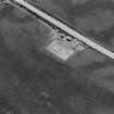
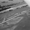
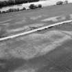
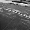
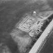
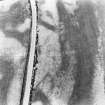
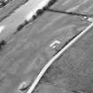
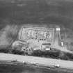
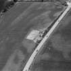
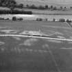
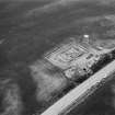
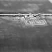
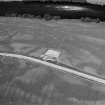
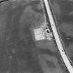
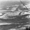
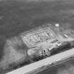
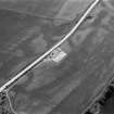
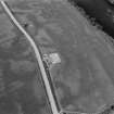
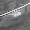
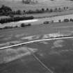
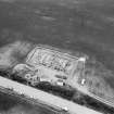
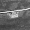
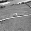
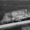
Aerial photography by the RCAHM in 1976 revealed parch marks in pasture at Balbridie which apparently outlined a timber hall measuring 26m by 13m, whose plan was so similar to that of hall A on Doon Hill, Dunbar (NT67NE 63) even in respect of internal detail, that it was assigned to the Dark Age period almost without question. The site was excavated between 1977 and 1980 by N Reynolds and I Ralston who showed that the building was made of vertical posts, linked by upright timber walling set in a construction trench. Replacement of the timber indicated a long life-span for the building; it was finally destroyed by fire and its timbers pulled out, allowing charcoal and burnt material to fall back into the empty sockets. Radiocarbon dates of 4840 +- 155, 4740 +- 130, 5150 +- 60 bp were obtained from samples of this charcoal. Small finds were few, but included flints, minute quantities of burnt bone, and fragments of Unstan ware: emmer wheat was the principal cereal represented.
I Ralston and N Reynolds 1977; 1979; 1980; G S Maxwell 1978; N Reynolds 1980; Curr Archaeol 1980; NMRS, MS/2222.
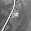
The site of the Neolithic timber building, which was excavated in 1977-81, lies 210m WNW of Balbridie Cottage; it was bow-ended and measured 26m in maximum length by 13m in breadth.
I Ralston and N Reynolds 1981; I Ralston 1982; RCAHMS 1984, visited June 1984
In 1976, air photography (by RCAHMS) revealed an apparently isolated structure of roughly rectangular form, measuring some 24m by 12m with varied internal features and bowed gable-ends. Excavation (1977-81) was carried out by I Ralston and N Reynolds, beginning on the basis of similarity to the excavated Dark Age structure at Doon Hill, Dunbar (NT67NE 63), and with the specific intention of investigating the timberwork.
The initial season confirmed the ploughed-down nature of the remains, degradation being most severe on the uphill (northern) side. The structure was found to have burnt down, leaving numerous carbon-rich contexts. Routine wet- and dry-sieving was instituted, and carbonised wood was collected for radiocarbon dating. Artifactual discoveries were few and undiagnostic.
The second season was notable for the recognition of the use of prepared timbers; some of the major internal roof species had evidently been squared. The structure was recognised as a single substantial) hall; no central line of posts was noted and (unlike at Doon Hill) there was no external buttressing.
Radiocarbon determinations were also received which indicated a Neolithic date, although no British or European parallels were then known. The possibilities were considered (but rejected) that a Pictish building had been erected on the site of Neolithic activity, or that the building had been constructed of bog oak. Significantly, emmer wheat was shown to be the major species represented, the radiocarbon determination (GU-1421) for a bulk sample falling within the series first obtained.
Examination of turf used in re-packing some of the features (notably the outer construction trench) has been identified as representing a brownearth in the initial stages of podsolization, appropriate to a Neolithic horizon at this latitude. Small quantities of unabraded decorated pottery were also recognised as comparable to Unstan ware; no diagnostic post-Roman artifacts were found.
Although soil acidity has eliminated all bone material, the site is significant for the large quantity of plant macrofossils recovered. Some 20,000 cereal grains have been counted to date, forming the largest known assemblage of carbonised grain of Neolithic date in Britain. Apart from the ubiquitous presence of wood fragments, carbonised plant remains were recovered in varying concentrations from almost all features. The cereal crops were generally 'clean', few spikelet fragments or other equivalent detritus being recovered. Relatively few weed seeds and remains of collected foodstuffs (other than hazelnuts) have been recovered. Crab apple is the only unexpected species among the non-agricultural species,
The principal cereals identified are emmer wheat, naked barley and forms of a free-threshing (hexaploid bread) wheat; these species typically represent slightly less than 80%, 18% and about 2% of the excavated assemblage. Exceptionally, one posthole (forming an integral part of the structure) is comprised of some 76% bread wheat, suggesting that this was treated on occasion as a separate (although not pure) crop, possibly on account of its gluten content. Grains of oar grain (probably of wild origin) were also identified. Flax was also represented by its carbonised seeds, the biggest concentration comprising 48 seeds from an aisle post-hole; the significance of this species remains unclear.
The recovery of carbonised grains from numerous internal features indicates that the handling of grain took place within the structure. Given the absence of evidence for storage-pits, above-ground storage appears possible.
The following radiocarbon determinations have been obtained:
Wood charcoal [contexts unstated]:
GU-1035 4840+/-165 bp
GU-1036 4740+/-135 bp
GU-1037 4930+/-80 bp
GU-1038i 5160+/-100 bp
GU-1038ii 5020+/-90 bp
GU-1828 5030+/-60 bp
GU-1829 4785+/-150 bp
GU-1830 4970+/-75 bp
GU-1831 5015+/-125 bp
GU-1832 4970+/-60 bp
Cereal grains [primarily Triticum spp: contexts unstated]:
GU-1421 4745+/-160 bp
Accelerator dates for specific species:
OxA-1767 4820+/-80 bp (Avena sp.)
OxA-1768 4940+/-70 bp (Linum usitatissimum.)
OxA-1769 5010+/-90 bp (Malus sylvestris)
A D Fairweather and I B M Ralston 1993.
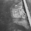
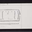
This massive structure is currently the only substantial and coherent building of demonstrable Neolithic date in the productive agricultural lands of the eastern coastal plains and SW Scotland. It has no excavated parallel, either in size (24.6m by 13.4m externally, with a total area of 329.6 sq m) or in mode of construction. Only the main structural elements survive, the remainder (and particularly the floor) having been removed by ploughing. A series of fourteen radiocarbon determinations places this building firmly within the early to mid 4th millennium BC; the accelerator dates (OxA-1767 to -1769) may be considered the most reliable. A function in the storage (rather than processing) of grain appears probable.
Although the largest building so far known from Britain and Ireland (and among the broadest in Europe), the Balbridie 'house' remains modest by European standards, possibly indicating a different function. In British contexts, the Balbridie structure is unique in scale, and possibly also in function. The orientation of Balbridie (E-W) is consistent with that of most Neolithic houses across Europe, but the prominent situation of its entrance in the E gable would have limited the amount of light entering the building, indicating that this was a secondary consideration. Further, an apparent barrier just within the entrance would have effectively prevented penetration by light into the interior.
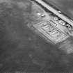
The building is defined by a wall slot containing substantial posts, and possibly the remains of plank walling. Within the enclosed area there are several arrangements of posts, some elements of these being set in transverse slots. Two longitudinal lines of seven posts seven posts are set about 1m in from the side walls, and have presumably supported two longitudinal roof beams; some of the posts of this line are incorporated into the ends of transverse slots. The roof could not have been supported on the walls and these posts alone; and it is possible that posts (both freestanding and within the transverse walls) nearer the axis supported two further longitudinal beams.
No plans yet published show the precise location of postpipes, but it can be suggested that the internal slots fulfilled the same function as the wall-slots, holding both structural timbers supporting longitudinal roof beams and continuous walling. Accepting this interpretation, all the internal slots would support screens, suggesting that different parts of the roofed space had different functions. There would also have been no direct access or visual sight-line into the interior.
Balbridie is a prime example of a Neolithic building of unusual form, and presents exceptional evidence for overtly ritual or ceremonial activity. The symmetrical layout, unusual length and single entrance of the structure may have been intended to create 'directionality', while the internal plan suggests a series of three continuous barriers laid deliberately across the direct axial access from the door to the opposite (W) end of the building. These barriers take the form of linear construction trenches, which may have held vertical partitions of various lengths.
The 'central' area (measuring about 9.5m long) between the second and third transverse barriers, may have been the principal 'activity area' of the building, and also served as a ceremonial 'arena' in front of the third barrier. The pits and postholes held sets of paired vertical fittings, perhaps for a ritual structure. The barrier to the w has slight returns at the ends, presenting the impression that it enclosed the 'activity area' to the E. Gaps of about 1m were left for passage around each end.
The area to the W of the third linear barrier may have been a ritual 'sanctum' repository for significant or ancestral relics, hidden from display but indirectly inaccessible. A single posthole (the only one set on the centreline of the building) is situated immediately W of the barrier; two further postholes and an irregular bulbous trench may have held a further ritual structure. Activities in this area apparently took place in the third (vertical) plane, possibly creating a display across the W gable.
G Barclay 1996; J Thomas 1996; P Topping 1996.
Air photographs showing cropmarks: AAS/97/10/G20/11-15 and AAS/97/10/CT.
NMRS, MS/712/29.
(Location cited as NO 7328 9592: nominated as Site of Regional Significance). Air photography has revealed the cropmarks of a timber structure which was initially thought to be Dark Age or Medieval but was shown by excavation (Ralston and Reynolds, 1977-81) to be a Neolithic structure of considerable size and sophistication which had been burnt down. The wall-posts had been set into a continuous foundation-trench and the ends angled outwards in a slight V-shape; the hall was sub-divided into three internally and two types of screens stood in front of the entrances to E and W. Sherds of Unstan ware, flints and burnt grain were found inside.
Radiocarbon dates: 2890 +/- 155 bc; 2790 +/- 130 bc; 2980 +/- 70 bc; 3210 +/- 60 bc. Wet sieving was also carried out; palaeoenvironmental samples were taken.
[Air photographic imagery and newspaper/magazine references listed].
NMRS. MS/712/35 and MS/712/36.
Project (1 June 1976 - 31 August 1976)
On the recommendation of the Committee for Rescue Archaeology set up by the Scottish Ancient Monuments Board a grant was made to the Commission in 1976 to allow it to carry out an extensive aerial survey programme. Climatic conditions during the period June-August were exceptionally favourable in much of eastern Scotland and more than 600 monuments were recorded, the majority being identified by means of crop-markings, a large number of which were new discoveries. The most interesting sites included Dark Age or Medieval timber halls on Deeside (NO 737967 [NO79NW 18], 733959 [NO79NW 16]) and west of Brechin (NO 509585 [NO55NW 40]); new Roman temporary camps at Ford, Midlothian (NT 384638 [NT36SE 18]) and Millside Wood [sic], Roxburghshire (NT 690270); double pit-alignments at Kinnell and Kinalty, Angus (NO 605494 [NO64NW 27], 356512 [NO35SE 32]); and a number of small, square-ditched enclosures, possibly barrows of the later Iron Age, in the Lunan valley, Angus (NO 626491 [NO64NW 95], 618494 [NO64NW 41] and 687509 [NO65SE 18]). A summary list of all these sites has been compiled and the prints will shortly be available for inspection in the National Monuments Record of Scotland.
RCAHMS (DES 1976, 84)

