
Sanday, Tres Ness


Chambered Cairn (Neolithic)
Site Name Sanday, Tres Ness
Classification Chambered Cairn (Neolithic)
Alternative Name(s) Tresness
Canmore ID 3566
Site Number HY73NW 4
NGR HY 71092 37511
Datum OSGB36 - NGR
Permalink http://canmore.org.uk/site/3566


- Council Orkney Islands
- Parish Lady
- Former Region Orkney Islands Area
- Former District Orkney
- Former County Orkney
HY73NW 4 7110 3752.
(HY 7110 3752) Brough (NR)
OS 6" map, Orkney, 2nd ed.,(1900).
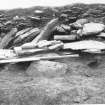
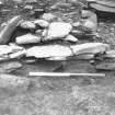
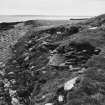
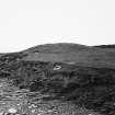
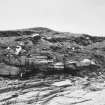
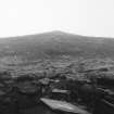
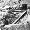
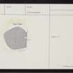
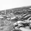
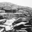
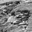
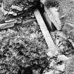
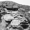
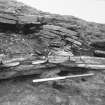
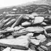
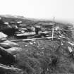
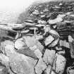
An uncertain chambered cairn composed of flat loosely-laid slabs, now turf-covered, appears to have a diameter of about 50', though it has probably been longer from north to south. In the section exposed along the shore the cairn material can be seen to spread for as much as 30' on either side of the entrance and it is possible that the cairn has been built on a low platform.
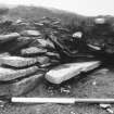
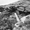
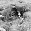
The sea has eroded the south edge of the mound exposing the outer end of a passage facing due south leading into the centre of the mound. It is partly choked with debris, but the side walls built of thin slabs are exposed to a depth of a foot, and a lintel can be seen in situ over them. About 10' to the east erosion has exposed a short length of wall-face apparently running parallel to the passage and facing the east. On the east side of the mound about 5' within its edge are two thin slabs on end which might be part of an encircling wall.
In the centre of the mound a small hole has been howked and here a 3' length of wall-face of thin slabs is exposed facing ESE, presumably part of a chamber. It is probable that most of the internal structure remains undisturbed.
A S Henshall 1963, visited 1957.
As described and planned by Henshall. Undoubtedly a chambered cairn.
Visited by OS (NKB) 14 July 1970.
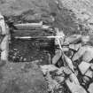
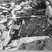
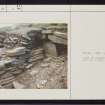
In May 1983, the cliff section was recorded prior to further sea erosion. A square masonry chamber, with its lintelled entrance inland, was located centrally within the cairn mound material of rubble and earth. The cairn seemed to be supported 3-3.5m either side of the chamber by single face walls. External to the East wall was evidence of another chamber or cell. The central chamber, although partially exposed was backed (to the sea) by a semi-circular single faced wall and collapsed upright slabs. This may have joined with the two mound retaining walls.
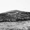
Most of the tomb lies inland under a mound 7.76m high, which on the cliff edge was partially encircled by a line of masonry which crossed the entrance of the exposed central chamber.
Records and report with the NMRS.
Sponsor: SDD(AM)
B Smith 1983
Note (1980)
Tres Ness, Sanday, ORK 50 HY 7110 3752 HY73NW 4
Probable Maes Howe-type cairn on extremity of Tresness; interior probably survives undisturbed, but seriously threatened by sea erosion.
RCAHMS 1980
(RCAHMS 1946, ii, p. 168, No. 447; Henshall 1963-72, i, 239; OR 330)
Field Visit (1999)
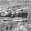
This chambered cairn lies adjacent to the coast edge and is eroding. Limited rescue investigation was carried out in 1983 and indicated that up to three structural phases may be present. The earliest phase, represented by a stalled cairn was later replaced with a circular structure and a rounded mound. The chamber of the stalled cairn, which is partially exposed in the coastal section, extended for at least 9m in length and was up to 1.4m wide. Fragmentary remains of a later circular structure were found at the southern end of the primary chamber. The rounded mound, which forms the latest and most prominent feature of the site, measures about 14m in diameter and stands up to 1.3m high. The site remains very vulnerable to coastal erosion. Ref.: RCAHMS (1946) # 447; Henshall, A S (1963) 'The Chambered Tombs of Scotland', 1, #ORK50; RCAHMS (1980) #5; Davidson J L & Henshall, A S (1989) 'The Chambered Tombs of Orkney, #50; Smith, B (1983) Tresness, Sanday (Lady parish) stalled tomb' in DES; Smith, B (1983) Tressness-unpublished site record & report , NMRS.
Excavation (14 August 2017 - 5 September 2017)
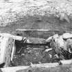
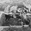
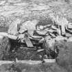
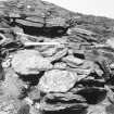
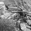
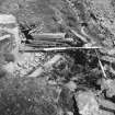
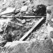
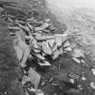
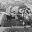
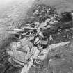
HY 711 375 An excavation was undertaken, 14 August – 5 September 2017, which opened a 12 x 3m exploratory trench over the main body of the chambered cairn, running roughly N/S and in line with the chamber. No archaeological deposits were excavated but we did reveal the remains of a well preserved cairn. The chamber had clearly been investigated in recent times with loose slabs lying close to and in the top of the chamber: this is probably the result of antiquarian activity. The very top courses of dry stone walling with a single visible orthostatic stall were visible in this area.
Archive: NRHE
Funder: Royal Archaeological Institute
Vicki Cummings, Jane Downes, Chris Gee and Colin Richards – UHI
(Source: DES, Volume 18)
OASIS ID: vickicum1-300186
Archaeological Evaluation (2018)
HY 711 375 A large evaluation trench was opened over the western half of the Neolithic chambered tomb at Tresness, Sanday in 2018.
A well-preserved cairn was uncovered which appears to survive to a height of 1.5 metres. No material was excavated although there were a number of stone tools found on top of the cairn. The trench also incorporated the chamber, revealing the remains of a stalled chamber surviving to roof height but with the roof slabs displaced. The entirety of the chamber was filled with loose slabs which were excavated to a depth of approximately 1m. However, it became clear that to the south of the chamber there had been considerable interference - possibly the insertion of a souterrain in the Iron Age. In this area the walls and stalls of the chambered tomb had been removed. Running E-W across the chamber was a poorly-built wall. The presence of a souterrain at the southern end of the chamber would explain the remains visible on the ground, including the smashed stalls found in the eroding section to the south. The chambered cairn to the north, however, appears to be well-preserved.
Archive: NHRE (intended)
Funder: Orkney Islands Council
Vicky Cummings – University of Central Lancashire and UHI
(Source: DES Vol 20)

