
Image Wood


Four Poster Stone Circle (Bronze Age)(Possible)
Site Name Image Wood
Classification Four Poster Stone Circle (Bronze Age)(Possible)
Alternative Name(s) Aboyne
Canmore ID 35277
Site Number NO59NW 1
NGR NO 5240 9904
Datum OSGB36 - NGR
Permalink http://canmore.org.uk/site/35277


- Council Aberdeenshire
- Parish Aboyne And Glentanar
- Former Region Grampian
- Former District Kincardine And Deeside
- Former County Aberdeenshire
NO59NW 1 5240 9904.
(NO 5240 9904) Stone Circle (NR) (Remains of)
OS 6" map, (1959)
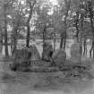
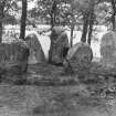
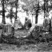
Aboyne Stone Circle: An extremely small stone circle; the space between the inner faces of its N and S stone is only 11' wide. The two stones on the N are close together, and all the stones are erect and massive. The circumference, taken through the centres of the stones, is exactly 40'. A very slight mound rises round the bases of all the stones, causing the enclosed space to be slightly higher than the level of the ground outside, possibly due to the modern path being carried around the circle. Some years ago Lord Huntly dug a trench at this circle and "only some black earth and cinders were found."
F R Coles 1905.
A setting of five stones, generally as described and planned by Coles. The most northerly stone is canted to the N, and though earthfast, may not be in situ. Without this stone, the remains could be either a "four poster" or the remains of a small stone circle of the transitional type described by Burl (1971).
Resurveyed at 1:2500.
Visited by OS (A A) 12 August 1972.
Field Visit (3 October 2016)
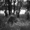
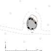
This stone setting is situated on the crest of a low whaleback ridge in an oak plantation about 570m SW of Aboyne Castle. It consists of five orthostats surrounding a low, flat-topped, grass-grown stony mound measuring 5.2m from NNW to SSE by 4.2 m transversely and 0.15m high. These stones, which are heavily encrusted with lichen, vary in size from 0.75m high by 0.63m wide and 0.37m (2) thick to 1.24m high by 0.8m wide and 0.55m thick (4). They fit to a circle with a 2m radius on plan and appear to be graded, increasing in height from S to N. All remain vertical except one which leans N (5).
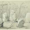
The Reverend Robert Miller referred to this ring as 'a small Druidical circle' in 1842 (NSA, 12, Aberdeenshire, 1059). At that time it was situated in the vicinity of the Class III Pictish stone from New Kinord (NO49NW 14), which had been re-erected as an ornament in the woodland by the Earl of Aboyne. James Drummond's pencil sketch taken ten years later indicates that the ring had reached its present state (ABD 527/4), while its location about 40m NNE of the Pictish stone is shown on the 1st edition of the OS 6-inch map (Aberdeenshire 1870, Sheet LXXXII; Name Book, Aberdeenshire, No. 4: Aboyne, 50). Both evidently acted as focal points within a network of paths that still largely survives. Coles, who planned and described the site in 1904, hoped to excavate the ring and believed he could do so 'with ease in one day', but he later learned that it had already been investigated by Charles Gordon, 11th Marquess of Huntly, who had found 'only some black earth and cinders' (Coles 1904-5, 206-8). It is plain from Ritchie's photograph of 1910 - its perspective conscientiously evoking Drummond's sketch - that both the woodland walks and the environs of the ring continued to be well maintained by the Marquess' agent (AB2796). A new plan was taken about this time by Sir Alexander Ogston, who had become interested in its possible archaeoastronomical properties following Sir Norman Lockyer's studies in Aberdeenshire and elsewhere (Ogston 1931, 87-8). However, Keiller, who planned the site again in 1927, was more interested in classification and was the first to identify its similarity to Glassel (NO69NW 2). He understood that the setting had probably been originally symmetrical and it was this perception that led him to calculate that a sixth or even a seventh orthostat must be missing. Burl settled on six stones as the likely total by analogy with other small sites like Backhill of Drachlaw (NJ64NE 6) (Burl 1976a, 188; 1995, 100; 2000, 230), but it was perhaps the ring's deliberately planned 'druidical' setting, intended for the leisurely contemplation of times past, as well as the former presence of the Pictish stone, that led him to suggest that it might be a folly (Burl 1995, 100-101). While this cannot be ruled-out entirely, as the grading of the stones is unexpected, the diameter is small and the setting has evidently been disturbed, it is unlikely that Gordon would have undertaken an excavation had he any doubt as to the ring's authenticity. As Keiller believed, its best analogues are the six-stone rings like Backhill of Drachlaw (NJ64NE 6), Glassel (NO69NW 2), Hill of Tuack (NJ71NE 27), South Ythsie (NJ83SE 12) and quite possibly Deer Park, Monymusk (NJ61NE 1). As such, it may date from the Early Bronze Age.
Visited by HES, Survey and Recording (ATW, AMcC), 3 October 2016
Measured Survey (3 October 2016)
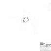
HES surveyed Image Wood stone circle with plane-table and alidade on 3 October 2016 at a scale of 1:100. The resultant plan was redrawn in vector graphics software.

