 |
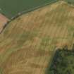
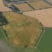
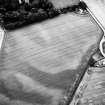
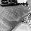
On-line Digital Images |
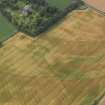
DP 050418 |
RCAHMS Aerial Photography Digital |
Oblique aerial view of the cropmarks of the rig and furrow and possible souterrain at Woodhill, taken from the NNE. |
23/7/2008 |
Item Level |
|
 |
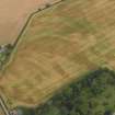
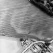
On-line Digital Images |
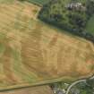
DP 050420 |
RCAHMS Aerial Photography Digital |
Oblique aerial view of the cropmarks of the rig and furrow and possible souterrain at Woodhill, taken from the WNW. |
23/7/2008 |
Item Level |
|
 |
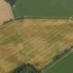
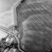
On-line Digital Images |
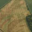
DP 050422 |
RCAHMS Aerial Photography Digital |
Oblique aerial view of the cropmarks of the rig and furrow and possible souterrain at Woodhill, taken from the WSW. |
23/7/2008 |
Item Level |
|
 |
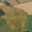
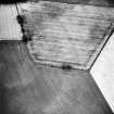
On-line Digital Images |
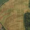
DP 050423 |
RCAHMS Aerial Photography Digital |
Oblique aerial view of the cropmarks of the rig and furrow and possible souterrain at Woodhill, taken from the WSW. |
23/7/2008 |
Item Level |
|
 |
On-line Digital Images |
DP 050424 |
RCAHMS Aerial Photography Digital |
Oblique aerial view of the cropmarks of the rig and furrow and possible souterrain at Woodhill, taken from the SW. |
23/7/2008 |
Item Level |
|
 |
On-line Digital Images |
DP 050425 |
RCAHMS Aerial Photography Digital |
Oblique aerial view of the cropmarks of the rig and furrow and possible souterrain at Woodhill, taken from the SSE. |
23/7/2008 |
Item Level |
|
 |
On-line Digital Images |
DP 050426 |
RCAHMS Aerial Photography Digital |
Oblique aerial view of the cropmarks of the rig and furrow and possible souterrain at Woodhill, taken from the S. |
23/7/2008 |
Item Level |
|
 |
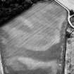
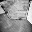
On-line Digital Images |
DP 050427 |
RCAHMS Aerial Photography Digital |
General oblique aerial view of the cropmarks of the rig and furrow and possible souterrain at Woodhill, taken from the E. |
23/7/2008 |
Item Level |
|
 |
On-line Digital Images |
DP 050428 |
RCAHMS Aerial Photography Digital |
General oblique aerial view of the cropmarks of the rig and furrow and possible souterrain at Woodhill, taken from the ENE. |
23/7/2008 |
Item Level |
|
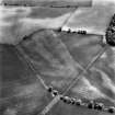 |
On-line Digital Images |
SC 1719872 |
RCAHMS Aerial Photography |
Oblique aerial view. |
1982 |
Item Level |
|
 |
On-line Digital Images |
SC 1719873 |
RCAHMS Aerial Photography |
Oblique aerial view. |
1982 |
Item Level |
|
 |
On-line Digital Images |
SC 1719889 |
RCAHMS Aerial Photography |
Oblique aerial view. |
1988 |
Item Level |
|
 |
On-line Digital Images |
SC 1719890 |
RCAHMS Aerial Photography |
Oblique aerial view. |
1988 |
Item Level |
|
 |
On-line Digital Images |
SC 1719891 |
RCAHMS Aerial Photography |
Oblique aerial view. |
1988 |
Item Level |
|
 |
On-line Digital Images |
SC 1719892 |
RCAHMS Aerial Photography |
Oblique aerial view. |
1988 |
Item Level |
|
 |
On-line Digital Images |
SC 1719893 |
RCAHMS Aerial Photography |
Oblique aerial view. |
1988 |
Item Level |
|
 |
On-line Digital Images |
SC 1719894 |
RCAHMS Aerial Photography |
Oblique aerial view. |
1988 |
Item Level |
|
 |
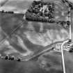
On-line Digital Images |
SC 1719955 |
RCAHMS Aerial Photography |
Woodhill House, oblique aerial view, taken from the NNW, showing cropmarks of rig and furrow cultivation. |
7/7/1995 |
Item Level |
|
 |
On-line Digital Images |
SC 1719956 |
RCAHMS Aerial Photography |
Woodhill House, oblique aerial view, taken from the W, showing cropmarks of rig and furrow cultivation. |
7/7/1995 |
Item Level |
|
 |
On-line Digital Images |
SC 1719957 |
RCAHMS Aerial Photography |
Woodhill House, oblique aerial view, taken from the SW, showing cropmarks of rig and furrow cultivation. |
7/7/1995 |
Item Level |
|
 |
On-line Digital Images |
SC 2408364 |
Records of the Ordnance Survey, Southampton, Hampshire, England |
Woodhill House, NO53SW 31, Ordnance Survey index card, Recto |
1958 |
Item Level |
|


