
Dundee, Broughty Ferry, Broughty Castle


Castle (15th Century)
Site Name Dundee, Broughty Ferry, Broughty Castle
Classification Castle (15th Century)
Alternative Name(s) Broughty Castle; Broughty Ferry, Castle Green; Broughty Ferry, The Harbour
Canmore ID 33391
Site Number NO43SE 10
NGR NO 46475 30427
Datum OSGB36 - NGR
Permalink http://canmore.org.uk/site/33391


First 100 images shown. See the Collections panel (below) for a link to all digital images.
- Council Dundee, City Of
- Parish Dundee (Dundee, City Of)
- Former Region Tayside
- Former District City Of Dundee
- Former County Angus
NO43SE 10.00 46475 30427
NO43SE 10.01 NO 4648 3040 Coast Battery
(NO 4650 3045). Broughty Castle on site of (NAT)
Broughty Castle (NR)
OS 1:10000 map (1974)
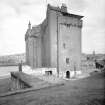
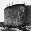
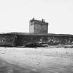
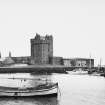
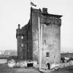
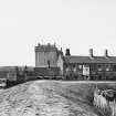
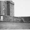
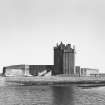
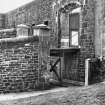
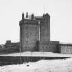
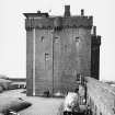
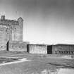
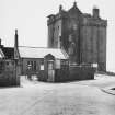
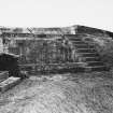
Broughty Castle, built c.1496 and allowed to fall into decay after 1603, has been completely restored and is in use as an Royal Army Service Corps (RASC) Depot.
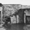
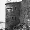
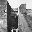
The E block is all that remains of the original keep. The castellated building attached to the NW is completely modern as is the circular tower contained in the re-entrant angle of the two blocks. The foundations of the main block show the original masonry, but the rest of the walls are faced with cement. The battlements are modern as are the courtyard walls.
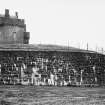
A print of 1831 and a photograph of 1853 in Dundee Reference Library show the shell of the keep and the courtyard wall with two towers. The keep was unbattlemented. (A J Warden 1882)
It is possible that there were pre-1496 defences on the rock.
Visited by OS (JLD) 30 April 1958
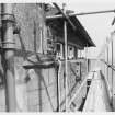
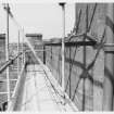
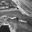
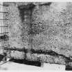
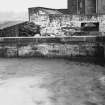
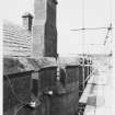
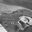
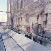
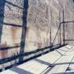
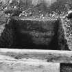
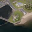
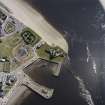
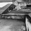
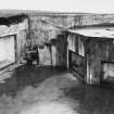
Installation of electric cables for floodlighting involved the excavation of 103m of cable trench on Castle Green and 31m in the courtyard. The trenches were 30cm wide at ground level and narrowed to 15cm to 25cm in the bottom; they varied in depth from 30cm to 50cm.
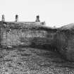
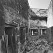
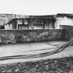
The Castle Green trenches showed extensive make-up/terracing deposits associated with the 1860s refortification of the site and 20th-century landscaping. The mound on which the 19th-century castle sits is built up of quarried sandstone and some revetting of the bedrock was seen. To the E of the ramp, the remains of a rubble-filled bunker were found on the site of the dynamo and engine rooms. A corner of the foundations/roof of another bunker was also seen at the N end of the ramp, and a gravel path crosses eastern Castle Green N to S.
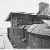
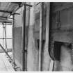
Inside the courtyard, the foundations of a 19th-century guardhouse were revealed and a substantial 2m-thick wall running NE to SW; this may represent the remains of a mid-16th-century angled tower known to have stood in this area. The majority of courtyard deposits were make-up for the battery and showed frequent re-surfacing of the courtyard.
Sponsor: Tayside Enterprise.
F M C Baker 1993.
NO 465 304 A small trench was excavated in January 2003 immediately N of the castle, E of the approach road, to investigate an area of sudden subsidence. A large pit was found cut into loose gravel, and appeared to have been inadequately backfilled. This pit is thought most likely to be from the extraction of a single large post, possibly a flagpole.
Archive to be deposited in the NMRS.
G Ewart 2003.
External Reference (4 February 1965)
Description:
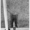
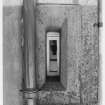
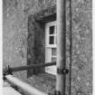
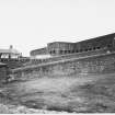
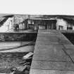
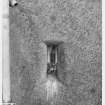
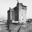
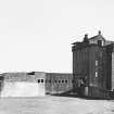
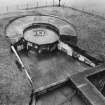
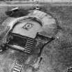
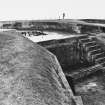
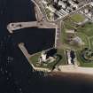
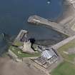
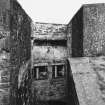
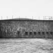
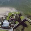
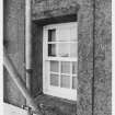
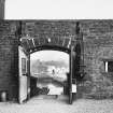
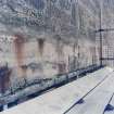
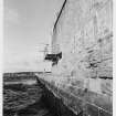
1490-96 tower house, restored from a derelict shell and made L-plan with single storey court of offices in re-entrant and new battery fortifications, Sir Robert Rowand Anderson, 1860-61; observation room at SE garret by Office of Works, 1942. 4-Storey and garret. Original tower house harled, snecked rubble elsewhere, ashlar dressings and parapet. Exposed base rock at N; 12-pane sash and case windows, glazed rectangular gunports, all with chamfered margins, relieving arches at unharled areas; horizontally splayed gunports at ground floor N and W elevations; corbelled and battlemented parapet with gun-barrel waterspouts; crowstepped gables; cap-house at SW angle; coped stacks; curtain wall at N and W, battery at S and E.
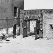
N ELEVATION: moulded segmental-arched entrance arch in curtain wall approached by ramp and drawbridge over dry ditch; 7 gunports at left, battery projecting at far left with 5 gunports. Castle at right: original building at left, harled with 2 openings at ground floor, window at 1st and 2nd floor, round-arched window at 3rd floor, 2 exposed cannon ball scars and small opening at 1st floor, gablehead stack behind parapet; slightly lower 1860-61 addition advanced at right, 2 horizontal gunports at ground floor left return, 2 gunports at 1st, 2nd and 3rd floors, 4 horizontal gunports at ground floor, 2 at 1st, 2nd and 3rd floors, gablehead stacks behind parapet.
W ELEVATION: 1860-61 castle addition at left with 4 gunports at ground floor, window and 2 gunports at 1st, 2 windows and gunport at 2nd and 3rd floors; round-headed door at right return, gunport at 1st floor, windows at 2nd and 3rd; capped segmental stair tower at re-entrant with moulded doorway at ground and 2 gunports above; original tower house at right with various windows and gunports, masked by high projecting wall with 5 gunports and 2 at left return; blank curtain wall further advanced at far right; angled projection with numerous gunports at outer right extending to S elevation.
S ELEVATION OF CASTLE: round-arched entrance at ground floor, gunports at left and right, 2 windows and various gunports at 1st, 2nd and 3rd floors, cap-house projecting through parapet at left, flat-roofed plate-glazed observation room at parapet walk extending to E elevation; curtain wall with arch to service court at ground floor left.
E ELEVATION OF CASTLE: round-headed entrance at right, 10 windows and gunports variously arranged over 4 floors.
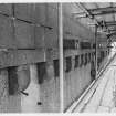
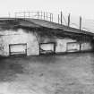
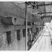
BATTERY: snecked rubble battery at S and E meeting at an obtuse angle with a caponiere; 7 gun emplacements; drawbridge lifting equipment at interior of entrance arch.
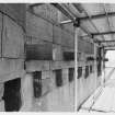
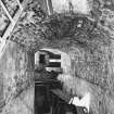
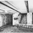
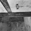
INTERIOR: 2 barrel vaulted ground floor rooms at each tower, single rooms at remaining floors of original building.
References:
Sir Francis Mudie, David Walker, Iain McIvor, BROUGHTY CASTLE AND THE DEFENCE OF THE TAY; (1979); David MacGibbon and Thomas Ross, THE CASTELLATED AND DOMESTIC ARCHITECTURE OF SCOTLAND. (1871 ed), v.iv, p 386; Bruce Walker and Graham Ritchie, DISCOVERING SCOTLAND'S HERITAGE, FIFE AND TAYSIDE, (1987); Sam McKinstry, 'The Life and Work of Sir Robert Rowand Anderson, 1834-1921', (1986), Phd thesis, University of St Andrews.
Notes:
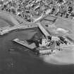
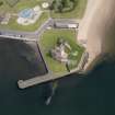
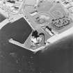
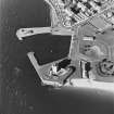
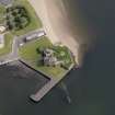
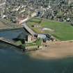
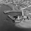
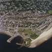
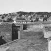
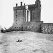
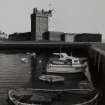
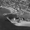
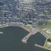
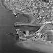
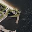
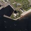
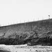
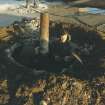
Broughty Castle is strategically situated at the inner mouth of the Tay on a site which was probably fortified before the present building was commenced in 1490. The Victorian reconstruction and extension followed purchase by the government in 1855 in response to the threat from Russian warships. Although one of Anderson's major early works, the re-fortification was never regarded as satisfactory. The carefully preserved battle scars on the N face of the tower were inflicted by Cromwells's forces furing the siege of 1651. Broughty Castle is of supreme picturesque importance; it is used as an outstation by Dundee Museums and Galleries, and is a Scheduled Ancient Monument in care.
Scheduled Area 2 March 1998.
Information from Historic Scotland, 4 February 1965
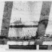
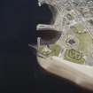
Aerial Photography (September 1970)
Oblique aerial photographs of Broughty Castle, Dundee, taken by John Dewar inSeptember 1970.
Publication Account (1987)
Broughty Castle dates back to the 15th century but by the mid 19th century it comprised a ruined shell. The site had obvious strategic importance and it was purchased by the Government in 1855 to protect the Firth of Tay from Russian warships. The Crimean War ended without any further action on the Government's part. The site stood derelict until the next war scare in 1860-61, when it was decided to reconstruct the castle as a small self-defensible coastal battery. The work was carried out by a young Royal Engineer, Robert Rowand Anderson, who was later knighted and received the RIBA Gold Medal for Architecture.
The project was ill-conceived in that the limitations imposed by this exposed and restricted site were not fully appreciated or considered, especially in the light of the recent introduction of built-up rifled guns. The brief called for a battery to control the entrance to the Firth of Tay and to be self-defensible from a possible surprise land attack. The Tay is only 335 m wide at this point and any problems in the siting of the guns were created partly by the shape of the site and partly by Anderson's decision to utilise the ruined tower house and enclosing wall.
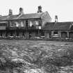
The tower was increased in size by the sensitive addition of another wing and was used as the barracks, apart from the vaulted ground floor which became the only magazine. Two 68-pound guns were placed behind the west curtain to engage ships in the river. Two 10-inch guns covered the channel and three more faced the approach from the open sea. Between the two groups of 10-inch guns was a third 68-pound gun which could cover the sea approach or the channel. A fourth 68-pound gun was positioned at the landward end of the battery to cover the sea approach and the beaches to the east. A guardhouse was constructed to the east of the tower, controlling the drawbridge entrance. An enclosure was constructed at the southwest of the west curtain to cover the harbour area in case of land attack. This is considered to be the site of the hospital.
The tower-house and guardhouse were treated as an essay in historical architecture and contrast with the stark simplicity of the rest of the works which are unadorned military engineering.
Twenty-five years after the building of this fort, it was decided to make provision for laying a minefield in the Tay. An addition was made to the north-east of the fort to accommodate the Tay Division Submarine Miners RE (Volunteers) raised 17th March 1888. That same year Captain J G Grant lectured on 'The Defence of the Tay' describing Broughty Castle as:
'badly built, badly designed, and utterly useless
for the purpose for which it was
constructed . . . A fort such as this could never
defend our river, for its total demolition would
only afford an enemy an hour's pleasant and
agreeable recreation, unharassed by any
thoughts of possible danger to themselves.'
This brought about a number of compromise alterations. More alterations were made during both World Wars. In 1935 it passed into the care of the Office of Works.
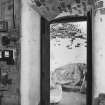
Broughty Castle was opened as a museum in 1969. This is a branch of Dundee Museum and has galleries depicting: the history and development of Broughty Ferry; the local fishing community; and the Dundee whaling museum.
Information from ‘Exploring Scotland’s Heritage: Fife and Tayside’, (1987).
Excavation (28 January 1993 - 5 February 1993)
Installation of electric cables for floodlighting involved the excavation of 103m of cable trench on Castle Green and 31m in the courtyard. The trenches were 30cm wide at ground level and narrowed to 15cm to 25cm in the bottom; they varied in depth from 30cm to 50cm.
The Castle Green trenches showed extensive make-up/terracing deposits associated with the 1860s refortification of the site and 20th-century landscaping. The mound on which the 19th-century castle sits is built up of quarried sandstone and some revetting of the bedrock was seen. To the E of the ramp, the remains of a rubble-filled bunker were found on the site of the dynamo and engine rooms. A corner of the foundations/roof of another bunker was also seen at the N end of the ramp, and a gravel path crosses eastern Castle Green N to S.
Inside the courtyard, the foundations of a 19th-century guardhouse were revealed and a substantial 2m-thick wall running NE to SW; this may represent the remains of a mid-16th-century angled tower known to have stood in this area. The majority of courtyard deposits were make-up for the battery and showed frequent re-surfacing of the courtyard.
F M C Baker 1993
Sponsor: Tayside Enterprise
Kirkdale Archaeology
Excavation (14 January 2003)
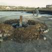
Under the terms of its P.I.C. call-out contract with Historic Scotland, Kirkdale Archaeology was asked to undertake an archaeological investigation of an area of subsidence. A small area of the grassed space immediately N of the Castle outer works and E of the approach ramp had suddenly subsided, creating a depression approximately 1m square and up to 0.5m deep. It was thought that this most likely reflected the site of an infilled structure or structures. One of a series of ‘primer pits’ shown on a plan of 1931 was thought a possible candidate.
The cause of the subsidence is the presence of a large hole, which may not have been adequately backfilled during the general landscaping of the area after the clearance of various military structures. The 1931 plan shows a series of buildings including a coal store, drill shed, refectory (?) and 3 primer pits although none of them are on the site of F003. The plan also shows a series of tramways for transport of ammunition and various water services, and they too do not appear to be associated with the pit F003.
The pit itself is most likely the result of the extraction or robbing of a single post or bollard. The size of the pit suggests that the post was large, possibly a flagpole.
It is noteworthy that there was no sign on the ground of the 1931 concrete yard surface which appears to have been completely removed before F002 type material was brought in.
The precise cause of the recent collapse is not immediately obvious but probably reflects slippage within pit F003. This may have been caused by movement at the sides of the pit which were unstable and prone to collapse, due to the looseness of the gravel into which the hole was cut.
G Ewart 2003
Sponsor: Historic Scotland
Kirkdale Archaeology
Standing Building Recording (February 2005)
Headland Archaeology carried out documentary research and assessment of the standing remains 1860-1945 of Broughty Castle, Broughty Ferry.
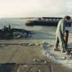
Resistivity (12 December 2008)
Geophysical survey was to be undertaken at Broughty Castle as part of an archaeological evaluation instigated because of the occurrence of subsidence events in an area of lawns to the north-east of the castle known as Castle Green, by Broughty Ferry, Dundee… Electrical resistance was used with the objective of assessing the presence of building remains and identifying areas at future risk of subsidence. The survey objectives were deemed to have been met through the provision of the possible location of additional voids, correlating with the site of 19th century primer pits and other ancillary military buildings adjacent to the Broughty Castle ramp. Moreover the results indicated variation in the survival of building remains across the site, including areas of general clearance, possible robbed wall foundations and in situ foundations.
NO 4647 3042 A geophysical survey was undertaken on 12 December 2008 as part of an evaluation to investigate the potential causes of subsidence in an area of lawns known as the Castle Green; formerly the site of a 19th-century mariners’ military base. A resistivity area survey (0.16ha) and resistivity profiling were undertaken. The site of 19th-century primer pits and ancillary military buildings were identified, with areas of potential voiding.
Report: Perth and Kinross Heritage Trust, KHT, Local Authority Archaeological Advisor, OASIS: Scotland and RCAHMS (intended)
Funder: Kirkdale Archaeology Ltd and Historic Scotland
Oliver O’Grady – Perth and Kinross Heritage Trust
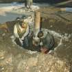
Excavation (4 February 2009 - 10 February 2009)
NO 4647 3045 Following examination of cartographic sources and a geophysical survey minor excavations were carried out, 4–10 February 2009, to investigate areas of subsidence to the N of the castle. The excavation uncovered what appeared to be the ‘primer pits’ shown on early OS maps of the area.
Archive: RCAHMS (intended)
Funder: Historic Scotland
David Murray – Kirkdale Archaeology
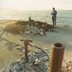
Watching Brief (29 September 2014 - 30 September 2014)
Under the terms of its PIC call-off contract with Historic Scotland, Kirkdale Archaeology was asked to undertake an archaeological watching brief during the installation of three lighting conductor mats and conductor strip at Broughty Castle, Dundee.
The findings of this exercise can be summarised as:
Disturbance and infill -
The excavation has confirmed the assumed high level of disturbance within the area immediately around the entrance to the tower. The general ground level is actually a terrace or platform, some 1m higher than the threshold of the tower entrance, and this in turn has been exploited to accommodate a wide range of power cables and services, some at least associated with the gun batteries themselves. No natural subsoil or buried ground surface was encountered during the recent excavation, suggesting that the extensive earthworks associated with the 19th - 20th century batteries have simply buried residual surfaces to a depth of at least 1m. At the depths exposed, there was no sign of a buried turf rampart associated with the 16th century fortification of the site.
Gun battery infrastructure -
The numerous heavy duty electrical cables which were revealed at various depths within the infill deposits are most likely part of the power supply to the batteries, and as such may date to the mid-20th century (possibly related to activity associated with WWII).
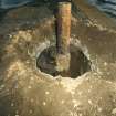
Less certain is the role of the inspection shaft (003); it was clearly abandoned and crudely backfilled suggesting it is not part of the current drainage arrangements for the site. The one rung exposed in the N wall of the shaft was not iron and may reflect attempts to minimise sparks by utilising white metal.
Watching Brief (August 2015 - March 2016)
NO 46476 30433 A series of watching briefs was carried out, August 2015 – March 2016, during test pitting and excavation in advance of the installation of a new gravity sewerage system within the grounds of Broughty Castle.
In the first phase three test pits were excavated, one of which revealed a brick and stone drain and a ceramic pipe, which probably related to drainage systems in place for now demolished 19th-century military and artillery buildings within the castle grounds. Modern service cables and field drains were discovered in the other two test pits.
In the second phase the remains of the former perimeter wall, the artillery store and a primer pit were discovered, all of which correspond to their locations on an early 20th-century plan of the castle and grounds. Part of a circular brick and concrete structure was also revealed.
Archive: NRHE (intended). Reports: Dundee City Archaeology Service and NRHE
Funder: Scottish Water
Ewan MacNeilage – CFA Archaeology Ltd
OASIS ID: cfaarcha1-222236
(Source: DES, Volume 17)

