
Balfarg


Grave (Prehistoric), Henge (Neolithic) - (Bronze Age), Inhumation (Prehistoric), Standing Stone(S) (Prehistoric), Timber Circle (Neolithic), Beaker (Bronze Age), Food Vessel (Bronze Age), Unidentified Pottery (Neolithic)
Site Name Balfarg
Classification Grave (Prehistoric), Henge (Neolithic) - (Bronze Age), Inhumation (Prehistoric), Standing Stone(S) (Prehistoric), Timber Circle (Neolithic), Beaker (Bronze Age), Food Vessel (Bronze Age), Unidentified Pottery (Neolithic)
Canmore ID 29990
Site Number NO20SE 5
NGR NO 28198 03123
Datum OSGB36 - NGR
Permalink http://canmore.org.uk/site/29990


- Council Fife
- Parish Markinch
- Former Region Fife
- Former District Kirkcaldy
- Former County Fife
NO20SE 5 28198 03123
(NO 2816 0312) Standing Stones (NAT)
OS 6" map (1947)
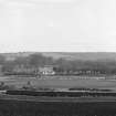
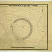
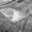
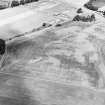
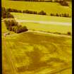
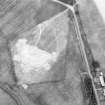
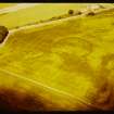
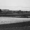
NO 2819 0312 - A Class I henge monument associated with two standing stones. The site was discovered from air-photographs by Dr K A Steer and surveyed by R J C Atkinson in 1950.
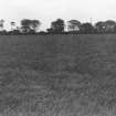
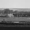
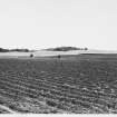
Traces of the enclosing bank exist to a height of 6 to 8 inches on the north and east; its original diameter could have been about 280 feet. The two standing stones are of undressed sandstone and lie some 45 feet apart. That on the north-west, 6 feet 7 inches high, was probably one of a pair set in the entrance-gap; the other, 5 feet 3 inches high, the survivor of a ring of stones set some 20 feet within the ditch and concentric with it.
R J C Atkinson 1952.
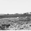
The extent of this henge cannot be definitely ascertained, only the two standing stones and a wide stony spread of stone can be seen in a ploughed field.
Visited by OS (RD), 14 April 1972.
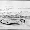
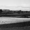
The site was totally excavated in advance of projected housing construction in 1977 and 1978. The excavation revealed clear evidence for the existence of a main timber circle, 25m in diameter, set concentrically to the enclosure ditch. This timber circle was associated with a substancial assemblage of grooved ware as well as other material. There is some evidence to suggest that five other concentric timber circles exist on the site which, where any evidence survives, would appear to be palisade-type structures. Massive natural erosion and agricultural damage to the site has also meant that the precise plan of stone settings on the site will never be known but there is evidence to suggest that two stone circles have existed on the site one outwith the other with the western entrance to the site marked by a single portal stone. There is some evidence to suggest that the stone settings are later than the timber structures.
Close to the centre of the monument a slab-covering pit concealed an inhumation of a young adult accompanied by a handled beaker.
After the excavation the site was restored, the ditches re-cut, and the stones re-erected.
R J Mercer 1982.
A small excavation was conducted to re-investigate the relationship of henge ditch to natural gully.
C J Russell-White 1988.
Further excavation across S section of ditch, December 1987.
(Revised final plan issued).
R J Mercer, G J Barclay, D Jordan and C J Russell-White 1989.
Field Visit (17 June 1925)
Standing Stones near Balfarg.
These two stones stand, 350 feet above sea-level, about a quarter of a mile south-west from the farmhouse of Balfarg. They are tall boulders of sandstone, roughly rectangular in shape but with somewhat pointed tops, and are set up, in a line running north-west and south-east, at a distance of 43 feet 8 inches from one another. Neither shows any trace of markings, nor do they appear to have been packed at the base. The measurements are :-
WEST STONE. Height, 6 feet 7 inches. Girth at base, 9 feet 8 inches. Girth at 4 feet up, 11 feet.
EAST STONE. Height, 5 feet 3 inches. Girth at base, 12 feet 3 inches. Girth at 4 feet up, 13 feet 2 inches.
They are not marked in Gothic letters on the O.S. map (xix S.E).
RCAHMS 1933, visited 17 June 1925.
Reference (1957)
This site is noted in the ‘List of monuments discovered during the survey of marginal land (1951-5)’ (RCAHMS 1957, xiv-xviii).
Information from RCAHMS (GFG), 24 October 2012.
Excavation (1977 - 1978)
The site was totally excavated in advance of projected housing construction in 1977 and 1978. The excavation revealed clear evidence for the existence of a main timber circle, 25m in diameter, set concentrically to the enclosure ditch. This timber circle was associated with a substancial assemblage of grooved ware as well as other material. There is some evidence to suggest that five other concentric timber circles exist on the site which, where any evidence survives, would appear to be palisade-type structures. Massive natural erosion and agricultural damage to the site has also meant that the precise plan of stone settings on the site will never be known but there is evidence to suggest that two stone circles have existed on the site one outwith the other with the western entrance to the site marked by a single portal stone. There is some evidence to suggest that the stone settings are later than the timber structures.
Close to the centre of the monument a slab-covering pit concealed an inhumation of a young adult accompanied by a handled beaker.
After the excavation the site was restored, the ditches re-cut, and the stones re-erected.
R J Mercer 1982.
Publication Account (1987)
These two sites (Balfarg and Balbirnie), along with structures that were found between them, form one of the most important groups of monuments of neolithic and bronze age date in eastern Scotland. The visible monuments are a henge and a small stone circle, now re-sited to the south-east ofits original position; excavations between them have, however, revealed a ditched enclosure, two timber structures, cairns and burials as well as a large quantity of pottery.
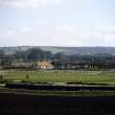
The henge monument of Balfarg was excavated in advance of house· building, but the development has been re-designed to allow the earthwork to form an open area, and now, with the partial digging out of the ditch, it offers a remarkable impression of the civil engineering skills of prehistoric man. The ditch encloses an area about 60m in diameter making use of a natural gully on its south-west flank; originally there would have been a large bank outside the ditch and together they would have formed a barrier around the central area. The entrance into the interior was across a narrow causeway on the west side. Several distinct phases of activity or construction were identified in the interior, the earliest involving the breaking of large numbers of pottery vessels and the burning of wood and bone. Later a circle of sixteen massive timbers was set up in pits with two unusually large timbers forming a detached 'porch' or entrance on the west side. These upright timbers are now marked by short posts, but the original posts may have been as tall as 4m on the west side of the circle to judge by the depth of the post-holes. The henge remained the focus for the construction of further rings of uprights, this time of stone. The surviving evidence is not as clear as in the earlier phase because the stones appear to have been set in hollows rather than in deep pits; nevertheless it may be suggested that there had been two concentric rings. The two ' impressive standing stones near the entrance causeway are, however, the only remaining features of this phase. The final period of prehistoric activity on the site is represented by the burial of a young person in a pit at the centre of the henge; the burial, accompanied by an unusual handled Beaker and a flint knife, was covered by a large slab weighing about two tons, which has been replaced in its original position.
At Balbirnie three burial phases of activity could be identified, although the disturbed nature of parts of the site meant that aspects of the sequence were tentative. There is no doubt, however, that the setting up of the ellipse of ten stones was the first phase with a rectangular kerbed area at its centre perhaps only a little later. Sherds of Grooved Ware pottery, in a style akin to that from Balfarg, were found within the filling of one of the sockets for one of the uprights. The purpose of the central setting is, however, obscure (it should be remembered that the crazy-paving within the reconstructed site is entirely modem). Perhaps a long time after the original building of the circle, the site was used as a burial-place. Two cists were constructed in pits which cut across the corners of the central setting, and this implies that its purpose had been forgotten by this time; the more central cist had been robbed in antiquity, and the burial which it contained had been scattered. The pit cutting through the north-west corner of the setting contained an undisturbed cist; when the capstone was removed the cist was found to be almost filled with earth and cremated bone (an adult female and a child), with a complete Food Vessel and a flint knife on the floor. One of the supporting stones behind the south end slab was decorated with seventeen cup-marks. Another small cist to the north-north-east of the centre contained a burnt bone toggle, while a disturbed cist to the south-east had a side slab decorated with cupmarkings and cup-and-ring markings; a cast of this slab has been used in the reconstruction.
Finally the interior of the circle had been covered by cairn material, perhaps covering smaller independent cairns that had protected the cists, and the cairn was used to receive deposits of cremated bones-as many as sixteen individuals-underlining the continued respect for the site as a focus for burials. After excavation in 1970 and 1971 the main elements of the site were re-erected by Glenrothes Development Corporation at a point some 125m SE of the original position. The pottery and decorated stones are on display in RMS, Queen Street, Edinburgh.
Information from ‘Exploring Scotland’s Heritage: Fife and Tayside’, (1987).
Measured Survey (28 June 1988)
RCAHMS surveyed Balfarg henge on 28 June 1988 with plane-table and alidade at a scale of 1:1250.
Note (January 2017)
An ancient site in a modern context
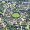
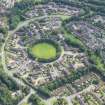
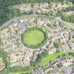
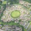
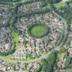
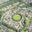
Located on the edge of the new town of Glenrothes, the henge is part of a larger complex of Neolithic sites in Fife. It consists of a circular ditch and bank with a single entrance. The construction was completed in phases. Around 6000 years ago pits were created and large amounts of pottery were deposited into them. Approximately 1000 years later further deposits of burnt bone, pottery and charcoal appeared at the site. It was after this that the Henge itself was constructed when a circle of 16 large timber posts were erected. Eventually they were replaced by a circle of standing stones. Two of the stones survive on the site and a modern version of the timber circle has been recreated. In the centre of the Henge a young male was buried and covered by a two ton stone which is also still visible.
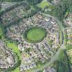
The strangest feature of the circle now is its location as the centre point of a circular housing estate built in the late 1970s called ‘The Henge’. The site was extensively excavated between 1977 and 1978 by Historic Scotland before the houses were built. The housing plans were permitted to go ahead, but only on the condition that the Henge remained intact as the focal point of the community. In 1996 the timber circle on the Henge was recreated, suggesting that the local community wanted more than just the knowledge of its existence, but wanted to re-build it to allow people to physically experience the structure.
Meaning in the past vs meaning in the present
We can attach meanings to prehistoric landscapes today, but when we combine advances in scientific knowledge with the modern, 21st century outlook we may create, and attach, meaning to these sites which would have been completely different to their creator’s ideas thousands of years ago. It is very hard to establish whether a potential relationship between the wider landscape and a monument was in fact a deliberate choice, or if it exists by chance. However, if you subscribe to the theory that the stones at Balfarg henge relate to the features in the landscape around them, we have to question if the current surroundings are influencing the original setting of the monument.
Glenrothes status as a new town now means that the connection between the inhabitants and the physical landscape, which the older residents of the community would have grown up with, has been greatly changed. When generations of a family have lived in the same place for a long time there is a feeling of ontological security, of being part of the place. Glenrothes was the first town in the UK to have an appointed town artist, David Harding. Harding wanted to address this issue and create artworks that could function as community landmarks and link the people to their environment. One of his works is called 'The Henge', a modern stone circle set in another council estate and created with the same material used for the houses surrounding it. It is now a focal point and meeting place for the community possibly echoing some functions of the original Henge. The ancient circle has woven its way into the fabric of the new town.
Another monument, Balbirnie stone circle, lies to the south east of Balfarg henge. Both monuments are thought to have been created around the same time and form part of a wider ceremonial complex. Balbirnie stone circle was situated next to the A92 trunk road which was widened in 1970. Unlike Balfarg henge, Balbirnie stone circle was not left intact when the road development occurred and was moved 125 metres to the south east of its original location. This completely changed the context of the monument in the landscape and arguably takes away from its meaning and significance. What do you think?
Catherine Mylles - Imagery Production Assistant, NCAP

