
Hedderwick Hill Race Course


Grandstand (20th Century), Racecourse (20th Century)
Site Name Hedderwick Hill Race Course
Classification Grandstand (20th Century), Racecourse (20th Century)
Alternative Name(s) East Links
Canmore ID 297261
Site Number NT67NW 149
NGR NT 64569 78648
NGR Description Centred NT 64650 78648
Datum OSGB36 - NGR
Permalink http://canmore.org.uk/site/297261

- Council East Lothian
- Parish Dunbar
- Former Region Lothian
- Former District East Lothian
- Former County East Lothian
NT67NW 149 centred 64569 78734
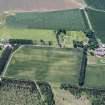
The remains of a horse racing course have been identified from RAF WW II vertical air photographs (106G LA/ 95, frmaes 5001-5003, flown 7 January 1945), immediately S of Hedderwick Hill Plantation and adjacent to East Links farmstead, now Hedderwick Hill cottages.
The racecourse, visible as slight remains, is an elongated oval track of nearly 1Km in length running E-W.
The racecourse and grand stand are depicted on the Revision Edition of the OS 25-inch map (Haddingtonshire, 1907, sheet 7), and annnotated 'Hedderwick Hill Race Course' with a roofed grand stand shown at c.NT 64650 78648.
Information from RCAHMS (DE), December 2008

