
Peffer Bank Wood


Field Boundary(S) (Period Unknown), Rig And Furrow (Medieval) - (Post Medieval)
Site Name Peffer Bank Wood
Classification Field Boundary(S) (Period Unknown), Rig And Furrow (Medieval) - (Post Medieval)
Canmore ID 286668
Site Number NT48SE 177
NGR NT 48526 81590
NGR Description Centred on NT 48526 81590
Datum OSGB36 - NGR
Permalink http://canmore.org.uk/site/286668


- Council East Lothian
- Parish Dirleton
- Former Region Lothian
- Former District East Lothian
- Former County East Lothian
NT48SE 177 NT 48526 81590 (Centred)
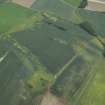
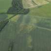
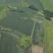
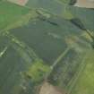
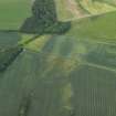
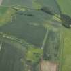
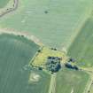
Two blocks of rig, situated to the S of the remains of Saltcoats tower-house, have been recorded as cropmarks on oblique aerial photography (RCAHMSAP 2006). Ploughed down field boundaries have also been recorded.
Information from RCAHMS (VLW) 22 February 2007

